Mt. Rainier Eruption: History, Hazards, and What Scientists Watch For
Mt. Rainier eruption history spans 500,000 years. Learn about the last eruption, lahar hazards, at-risk cities, and what scientists monitor today.
Will Mt. Rainier Erupt?
Mt. Rainier is an active volcano that last erupted roughly 1,000 years ago. The USGS classifies it as a "very high threat" volcano, with over 90,000 people living in its lahar hazard zones. Scientists monitor it continuously and expect days to months of warning before any future eruption. The greatest danger is not lava or ash, but lahars, volcanic mudflows that could reach nearby towns in 30 to 40 minutes. Check our real-time Mt. Rainier visibility forecast to see the mountain today.
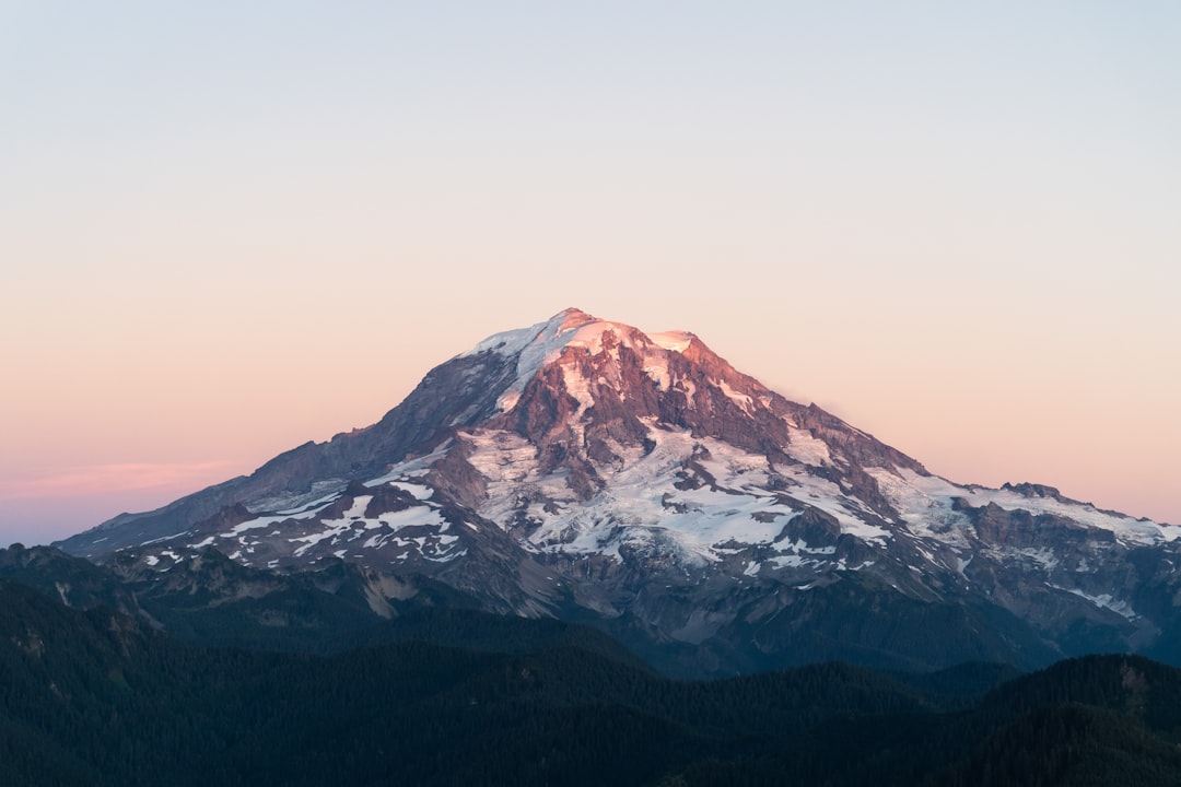
Mt. Rainier eruption history is one of the most consequential stories in Pacific Northwest geology. The mountain that defines the Seattle skyline is also an active volcano, one that last erupted in geologic terms less than a thousand years ago and sits atop more glacial ice than any other peak in the contiguous United States. Understanding what that means, in practical terms for the 90,000 people who live in its hazard zones, takes more than a list of dates.
Table of Contents
- Is Mt. Rainier an Active Volcano?
- Mt. Rainier Eruption History: A Timeline
- The Lahars: Mt. Rainier's True Eruption Threat
- Cities in the Path: Who Is at Risk
- How Scientists Monitor Mt. Rainier for Eruption Signs
- What a Future Eruption Would Look Like from Seattle
- Frequently Asked Questions
Is Mt. Rainier an Active Volcano?
Mt. Rainier is an active volcano. It has not produced a confirmed magmatic eruption in roughly 1,000 years, but geologists classify it as active because its eruptive record is geologically recent and its internal hydrothermal systems remain energized. The U.S. Geological Survey monitors it continuously and classifies it as a "very high threat" volcano.
Standing at 14,411 feet, Mt. Rainier is the tallest peak in the Cascade Range. That height is inseparable from its volcanic risk. The mountain carries more glacial ice than any other peak in the contiguous United States. More than one cubic mile of ice. That ice transforms any eruption scenario into something far more complex and destructive than simply lava and ash.
The Cascades are a volcanic arc, created by the ongoing subduction of the Juan de Fuca Plate beneath the North American Plate. Rainier is part of the same geological system that produced the catastrophic 1980 eruption of Mt. St. Helens, 55 miles to the southwest. The same forces are at work beneath Rainier. They are simply quieter for now.
Mt. Rainier Eruption History: A Timeline
Mt. Rainier's most recent confirmed magmatic eruption ended approximately 1,000 years ago. That period of activity, part of what geologists call the Holocene eruptive phase, included roughly a dozen significant eruptions over the past 2,600 years. The largest event in that recent window occurred about 2,200 years ago.
Zooming further back, the mountain's eruptive history spans roughly 500,000 years across five major geological periods, each characterized by different eruption rates and lava compositions. The volcano likely reached its greatest height during the Mowich period, between 280,000 and 160,000 years ago, before erosion and collapse events reshaped the summit.
Two named lahar events define the most consequential chapters in recent history:
The Osceola Mudflow, approximately 5,600 years ago. A massive collapse of the volcano's northeast flank released an estimated 0.91 cubic miles of debris. The resulting lahar traveled down the White River valley, inundating the lowland that would later become the sites of Auburn, Enumclaw, and much of the Puget Sound coastal plain south of Seattle, including areas that now form parts of Tacoma. Lahar deposits in some valleys reached 500 feet deep. It remains the largest debris flow of postglacial age in Mount Rainier's history.
The Electron Mudflow, approximately 500 years ago. A smaller but still geologically significant lahar flowed through the Puyallup River valley. The town of Orting now sits directly on top of this deposit.
The 19th century adds historical ambiguity to the record. Observers in Seattle and Tacoma reported what appeared to be eruptive activity in 1820, 1854, 1858, 1870, 1879, 1882, and 1894. Most geologists now interpret these as steam explosions rather than magmatic eruptions. The 1894-95 reports of minor summit explosions visible from the cities are the most credible recent accounts, but even these lack confirmed geologic evidence of magmatic activity.
The takeaway from the timeline: this mountain has never been quiet for long, measured in geologic time.
The Lahars: Mt. Rainier's True Eruption Threat
The greatest danger from a Mt. Rainier eruption is not lava. It is not even ash. It is lahars, the volcanic mudflows that can travel at highway speeds and carry boulders the size of houses.
A lahar forms when volcanic heat rapidly melts glacial ice and snow. The meltwater immediately picks up loose rock, volcanic sediment, and debris, becoming a dense slurry that accelerates down river valleys. Near the summit, lahars can reach 45 to 50 miles per hour. Downstream, they slow to 15 to 25 miles per hour. Still fast enough that anyone who has not already evacuated faces catastrophic danger.
Mt. Rainier does not need a full magmatic eruption to trigger a major lahar. A sector collapse, where a portion of the summit or flank slides away due to internal structural weakening, can generate a debris avalanche that melts ice on contact and transforms into a lahar without any fresh magma. The west flank of the mountain carries the highest risk of this kind of collapse because hydrothermal fluids have been converting solid rock into weak, clay-rich material for thousands of years.
The USGS lahars and debris flows page describes the west flank as having "the greatest potential for unleashing large landslides that become far-traveled lahars." The Osceola Mudflow began exactly this way, 5,600 years ago.
Lahars can also occur independently of volcanic activity. Small debris flows within the park are routine, essentially annual events. The heavy precipitation patterns that define Mt. Rainier weather keep the volcanic debris saturated and mobile. This is not merely a future eruption concern. It is an ongoing geological reality.
Cities in the Path: Who Is at Risk
The rivers draining Mt. Rainier's flanks define precisely who lives in lahar hazard zones. This geography does not change.
Orting is the community most frequently cited by emergency planners. A town of roughly 8,000 people, it sits directly on top of the Electron Mudflow deposit with no elevated terrain to retreat to. USGS modeling suggests a major lahar from the mountain would reach Orting in approximately 30 to 40 minutes. The town has conducted lahar evacuation drills for years because the scenario is not hypothetical. It is a matter of when, not if.
Puyallup, with a population approaching 45,000, lies in the valley that carries the highest lahar risk. The city shares the Puyallup River corridor with Orting and faces similar arrival time constraints.
Sumner, Buckley, and Auburn sit along the White River drainage, the same corridor the Osceola Mudflow followed 5,600 years ago. The historical precedent for these areas being inundated is not speculation. It has already happened.
A 2015 USGS study estimated more than 90,000 residents live in Mt. Rainier's lahar hazard zones, along with over 50,000 employees working at approximately 3,800 businesses.
| Location | Estimated Lahar Arrival Time |
|---|---|
| Areas within the park | ~5 minutes |
| Near-park communities | 15-30 minutes |
| Orting | 30-40 minutes |
| Puyallup | 40-60 minutes |
| Port of Tacoma | 60-90 minutes |
The Port of Tacoma handles tens of billions of dollars in trade annually. A lahar reaching the port would constitute one of the most costly infrastructure disasters in American history.
Seattle itself is not in a lahar hazard zone. The river valleys from Rainier flow south and east, not northwest toward the city. But Seattle's transportation links, supply chains, and regional economy are deeply interconnected with the communities that are. A major lahar event would not leave Seattle untouched, even if the mud itself never crossed the city limits.
For a geographic sense of where these communities fall relative to the mountain's slopes and river systems, our Mt. Rainier map guide shows the key drainage corridors and their relationship to the summit.
How Scientists Monitor Mt. Rainier for Eruption Signs
Mt. Rainier is watched continuously by the USGS Cascades Volcano Observatory in partnership with the Pacific Northwest Seismic Network at the University of Washington. The monitoring system is multi-layered because no single instrument captures the full picture of a volcano's behavior.
Seismometers detect earthquakes beneath the volcano. Mt. Rainier experiences roughly 20 small earthquakes annually at baseline. A spike in frequency, or a shift in where earthquakes cluster, signals potential magma movement. When earthquakes concentrate directly beneath the summit at shallow depths, scientists pay close attention.
GPS stations measure ground deformation at millimeter-scale precision. A rising magma body causes the ground surface to swell outward. GPS networks can detect these changes long before they become visible.
Tiltmeters measure subtle changes in the angle of the volcano's surface. Even a fraction of a degree of tilt on the upper flanks can indicate internal pressure shifts.
Gas sensors measure sulfur dioxide and carbon dioxide emissions. Increased SO2 in particular indicates fresh magma rising close to the surface, because sulfur is released as magma depressurizes on the way up.
In July 2025, Mt. Rainier experienced a swarm of hundreds of earthquakes beginning on the 8th, with events occurring at rates of several per minute and depths of 1.2 to 3.7 miles below the summit. USGS scientists analyzed the swarm and determined it showed no pattern consistent with magma movement or an impending eruption. The volcano alert level remained at GREEN/NORMAL throughout. The episode illustrates why continuous monitoring exists: without baseline data and real-time analysis, a brief intensification of seismic activity would have no interpretive context.
USGS states that a future magmatic eruption at Mt. Rainier will likely be preceded by days to months of detectable precursor signals, including increasing earthquake frequency, ground deformation, and elevated gas emissions. That warning window is why scientists prioritize monitoring above almost everything else.
A separate lahar detection system also operates along the main river corridors. Arrays of sensors monitor ground vibrations in the river valleys and can automatically detect a lahar's distinctive seismic signature, triggering alerts to emergency management agencies and activating sirens in communities from Orting to the Port of Tacoma. Pierce County runs periodic lahar evacuation exercises specifically designed around this warning system.
What a Future Eruption Would Look Like from Seattle
This is the question most eruption coverage skips. Not the hazard statistics. What would an actual eruption look like from the city 60 miles to the northwest that watches the mountain most closely?
From Seattle, the first visible sign of a significant eruption would be a rising plume above the summit. On a clear day, that column would be unmistakable, a vertical shaft of ash and steam growing upward from a peak that normally sits still against the horizon. The mountain would look nothing like itself.
A few specific things Seattleites should understand:
Ash goes east. Prevailing winds in Washington State blow primarily from the west and southwest. Ash from a Rainier eruption would travel east and northeast, toward Yakima, the Tri-Cities, and beyond. Seattle sits upwind in most weather patterns. The 1980 Mt. St. Helens eruption, far more explosive than most modeled Rainier scenarios, deposited only trace amounts of ash in Seattle while burying eastern Washington cities under inches. A Rainier eruption would follow the same pattern: western Washington watches, eastern Washington digs out.
Early stages bring spectacular visibility. The initial eruption column could reach 20,000 to 40,000 feet. That plume would be visible from hundreds of miles away on a clear day. From Kerry Park, Alki Beach, or any of the classic Seattle viewing spots for Mt. Rainier, the spectacle would be extraordinary, nothing like any mountain view in living memory.
As the eruption progressed, ash and steam would gradually obscure the summit and spread across the atmosphere. Anyone checking Mt. Rainier visibility conditions during an active eruption would see scores drop sharply as atmospheric particulates increased, similar to the way wildfire smoke events suppress visibility scores, but far more dramatic. Our visibility scoring methodology weights cloud cover, atmospheric particulates, and humidity together, all of which would be severely affected by volcanic ash.
Aviation is Seattle's main eruption risk. Volcanic ash is fatal to jet engines. A rising eruption column over Rainier would likely trigger the closure of Seattle-Tacoma International Airport for days or longer, even if ash accumulation at ground level in Seattle remained minimal. That disruption would affect the region far more immediately than any direct ashfall.
The lahar risk stops south of the city. The rivers that drain Rainier flow toward Orting, Puyallup, Auburn, and Tacoma, not toward Seattle. The map of lahar hazard zones is clear on this. What Seattle would experience is economic disruption, access route closures south of the city, and the weight of watching a landmark that defines its skyline in transformation.
For comparison, Mt. Fuji faces a similarly misunderstood visibility relationship with Tokyo. Our piece on whether Mt. Fuji is a volcano explores how Japan approaches volcanic risk communication for a mountain that anchors national identity much the way Rainier anchors Seattle's.
Frequently Asked Questions
When did Mt. Rainier last erupt?
Mt. Rainier's last confirmed magmatic eruption ended approximately 1,000 years ago, as the Holocene eruptive phase closed. Historical accounts from the 1800s describe what observers believed were eruptions in 1820, 1854, 1870, 1882, and 1894, but geologists now interpret most of these as steam explosions rather than magmatic events. No confirmed eruption with geologic evidence has occurred in the historical record.
Is Mt. Rainier overdue for an eruption?
The word "overdue" does not apply to volcanoes, which operate on no fixed schedule. Mt. Rainier has produced roughly a dozen significant eruptions over the past 2,600 years, with intervals between events varying enormously. USGS scientists state that "all evidence suggests the volcano will continue to erupt" based on its 500,000-year history, but they do not assign a specific probability or timeline to a future event.
Is Mt. Rainier more dangerous than Mt. St. Helens?
Many volcanologists consider Mt. Rainier more dangerous in terms of potential casualties, though not necessarily more likely to erupt. The 1980 Mt. St. Helens eruption killed 57 people in a relatively remote area. A comparable event at Rainier, or even a non-volcanic flank collapse, could threaten over 90,000 people in lahar hazard zones, including dense communities with limited evacuation routes and arrival times measured in minutes.
What is a lahar and why is it the main threat from Mt. Rainier?
A lahar is a rapidly moving volcanic mudflow, a dense slurry of debris mixed with water from melted snow and ice. Mt. Rainier carries more glacial ice than any other peak in the contiguous United States, which means any significant eruption or flank collapse would generate enormous volumes of meltwater almost instantly. Lahars from Rainier can reach 45 to 50 miles per hour near the summit and still move at 15 to 25 miles per hour when they reach populated valleys downstream, well beyond the speed at which most residents could evacuate on foot.
The mountain is being watched. Hundreds of seismic sensors, GPS receivers, tiltmeters, and gas monitors transmit data continuously to scientists whose job is to catch the earliest signals of renewed activity. If Mt. Rainier begins waking up, the geophysical fingerprints would likely appear days or months before any eruption. That lead time is the central argument for the monitoring infrastructure that exists.
In the meantime, the mountain remains what it has always been for the Pacific Northwest: a presence that defines the landscape and shapes the psychology of the cities that live beneath it. Check whether it is visible today at our Mt. Rainier visibility page, and appreciate the view for what it is, a brief window of calm from one of North America's most consequential volcanoes.
More Articles
Mt. Rainier Weather: Complete Guide to Conditions and Visibility
Plan your visit with our complete Mt. Rainier weather guide covering monthly conditions, precipitation, snowfall records, and how weather affects mountain visibility.
Mt. Rainier Height: How Tall Is Washington's Highest Peak?
Mt. Rainier height is 14,411 feet (4,392 m), making it the tallest mountain in Washington and the most topographically prominent peak in the contiguous US.
Is Mt Fuji a Volcano? Active Status, Eruption History & Facts
Is Mt Fuji a volcano? Yes, it's an active stratovolcano that last erupted in 1707. Learn about its eruption history, current status, and what scientists predict for the future.