Mt. Rainier Weather: Complete Guide to Conditions and Visibility
Plan your visit with our complete Mt. Rainier weather guide covering monthly conditions, precipitation, snowfall records, and how weather affects mountain visibility.

What is Mt. Rainier Weather Like?
Mt. Rainier weather is dominated by a Pacific maritime climate that brings wet, mild winters and cool, dry summers. The mountain receives an average of 500 inches of snowfall annually at Paradise and experiences rain on roughly 200 days per year. July and August are the sunniest months, while November through January bring the heaviest precipitation. Check our real-time Mt. Rainier visibility forecast to see how current weather affects mountain views.
Table of Contents
- Understanding Mt. Rainier Weather
- Monthly Weather Breakdown
- Mt. Rainier Weather by Elevation
- How Weather Affects Visibility
- Snowfall and Precipitation Records
- Where to Check Mt. Rainier Weather Forecasts
- Frequently Asked Questions
- Planning Your Visit
Understanding Mt. Rainier Weather
Mt. Rainier weather is shaped by the mountain's massive size and proximity to the Pacific Ocean. Standing at 14,411 feet, Mt. Rainier intercepts moisture-laden air flowing inland from the ocean, creating conditions that can change dramatically within hours. The National Park Service describes the climate as "generally cool and rainy," warning that wet, cold weather can occur any time of year.
The mountain essentially creates its own weather systems. As moist Pacific air rises against Rainier's slopes, it cools and condenses, producing clouds and precipitation that can blanket the peak while Seattle enjoys sunshine 60 miles to the northwest. This orographic effect explains why Paradise, at 5,400 feet, averages around 500 inches of snowfall annually while nearby lowland areas receive far less.
Seasonal patterns divide the year into two distinct periods. From October through May, Pacific storm systems deliver heavy rain and snow with persistent cloud cover. June through September brings the dry season, when high-pressure ridges push storms northward and clear skies dominate. Understanding this split is essential for planning any visit, whether you want to see Mt. Rainier from Seattle or explore the park itself.
Monthly Weather Breakdown
Mt. Rainier weather varies significantly by month. The following data reflects conditions at Longmire (2,762 feet), with Paradise and higher elevations running 5-10°F cooler.
Winter (December-February)
Winter storms deliver the heaviest precipitation and coldest temperatures. Roads above Longmire frequently close, and Paradise receives massive snowfall that buries buildings up to their rooflines.
| Month | Avg High | Avg Low | Precipitation | Snowfall (Paradise) |
|---|---|---|---|---|
| December | 36°F (2°C) | 26°F (-3°C) | 10.5 inches | 99+ inches |
| January | 36°F (2°C) | 26°F (-3°C) | 11.7 inches | 99+ inches |
| February | 40°F (4°C) | 27°F (-3°C) | 8.2 inches | 80+ inches |
Despite challenging conditions, winter produces some of the most spectacular views. When storms clear, dry cold air provides exceptional visibility. Fresh snow on the mountain against blue sky creates views that rival the clearest Mt. Fuji conditions in Japan. The key is catching those brief windows between storm systems.
Spring (March-May)
Spring brings gradually warming temperatures and decreasing precipitation, but weather remains highly unpredictable. Snow lingers at elevations above 5,000 feet well into mid-July.
| Month | Avg High | Avg Low | Precipitation |
|---|---|---|---|
| March | 45°F (7°C) | 29°F (-2°C) | 7.5 inches |
| April | 51°F (11°C) | 31°F (-1°C) | 5.7 inches |
| May | 58°F (14°C) | 37°F (3°C) | 4.8 inches |
Spring is a transitional season where you might encounter snow, rain, and sunshine all in the same day. Road access improves gradually, with the road to Paradise typically open year-round and the Sunrise road opening in late June or early July depending on snowpack.
Summer (June-August)
Summer delivers the best Mt. Rainier weather for visitors. July and August are the sunniest months, with minimal precipitation and the warmest temperatures the park experiences.
| Month | Avg High | Avg Low | Precipitation |
|---|---|---|---|
| June | 65°F (18°C) | 42°F (6°C) | 3.9 inches |
| July | 73°F (23°C) | 46°F (8°C) | 1.6 inches |
| August | 74°F (23°C) | 47°F (8°C) | 1.5 inches |
July and August combine to receive roughly 3 inches of rain total, compared to over 20 inches during November alone. This dry period coincides with the best time to see Mt. Rainier, when visibility rates peak and all park roads and trails are accessible. Wildflowers blanket subalpine meadows from mid-July through August, adding color to the mountain views.
Even during summer, temperatures drop sharply with elevation. Paradise sits 15-20°F cooler than Longmire, and conditions above the snowline remain wintry year-round. Afternoon thunderstorms occasionally develop on hot days, particularly in August.
Autumn (September-October)
Early autumn extends the pleasant conditions before Pacific storms return. September often provides excellent weather, while October marks the transition back to the wet season.
| Month | Avg High | Avg Low | Precipitation |
|---|---|---|---|
| September | 68°F (20°C) | 42°F (6°C) | 3.6 inches |
| October | 56°F (13°C) | 36°F (2°C) | 7.9 inches |
September frequently delivers some of the year's best visibility. Reduced humidity, stable air, and diminishing wildfire smoke create crisp views. By October, precipitation doubles and cloud cover increases, though clear days between storms can be spectacular.
Mt. Rainier Weather by Elevation
One of the most important factors in Mt. Rainier weather is how dramatically conditions change with elevation. The park spans from 1,600 feet at the Carbon River entrance to the 14,411-foot summit, encompassing multiple climate zones.
Lowland Valleys (1,600-3,000 feet)
The park's lowest elevations at Ohanapecosh and along the Carbon River experience the mildest conditions. Summer highs reach the upper 70s to low 80s°F, and winter brings more rain than snow. Ohanapecosh records summer highs of 81°F (27°C) in August, the warmest readings in the park.
Mid-Elevation (3,000-5,000 feet)
Longmire at 2,762 feet represents the transition zone. Winter brings a mix of rain and snow, with temperatures hovering near freezing. Summer highs reach the low 70s°F, making this zone comfortable for hiking most of the year.
Subalpine Zone (5,000-7,000 feet)
Paradise (5,400 feet) and Sunrise (6,400 feet) sit in the subalpine zone where snow dominates for eight months of the year. Paradise temperatures at this elevation range from 33°F high and 21°F low in January to 64°F high and 44°F low in July. Sunrise runs even cooler and windier due to its exposed position on the mountain's northeast side.
Alpine Zone (7,000 feet and above)
Above treeline, conditions become increasingly severe. Camp Muir at 10,080 feet experiences high winds, extreme cold, and whiteout conditions throughout much of the year. Summit temperatures rarely rise above freezing, and wind chill can drop well below -40°F during winter storms.
How Weather Affects Visibility
Mt. Rainier weather directly determines whether the mountain is visible from Seattle and surrounding areas. Understanding these connections helps you predict viewing conditions.
Cloud Cover
Cloud cover is the primary obstacle to seeing Mt. Rainier. The mountain's height means it catches clouds that pass well above the surrounding lowlands. Lenticular clouds, shaped like flying saucers, frequently cap the summit even on days when Seattle skies are clear. Low clouds and fog can obscure the entire mountain, while high thin clouds may allow views of the silhouette without fine detail.
Post-Storm Clearing
The 24-48 hours following a storm system often deliver the best visibility of the year. Storms scrub particulates from the atmosphere, and the trailing edge of weather systems brings cold, dry air from the north. If the forecast shows rain ending overnight, plan to check the Mt. Rainier webcams first thing in the morning.
Wildfire Smoke
Summer wildfire smoke has become an increasing factor in Mt. Rainier weather and visibility. Smoke from fires in Washington, Oregon, and British Columbia can reduce visibility to under 5 miles during severe episodes. August and September are the months most affected. Even when skies appear blue overhead, a hazy horizon often signals smoke that will obscure distant mountain views.
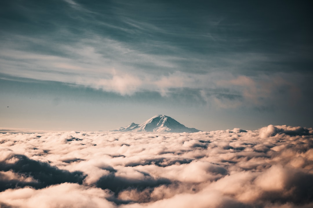
Temperature Inversions
Winter temperature inversions create interesting visibility conditions. Cold air settles in valleys while warmer air sits above, trapping fog and low clouds below certain elevations. Viewpoints above the inversion layer, such as Crystal Mountain or high ridges within the park, may offer crystal-clear views of Rainier rising above a sea of clouds while valley locations see nothing.
Snowfall and Precipitation Records
Mt. Rainier holds some of the most remarkable snowfall records in the world, which directly shape the weather conditions visitors encounter.
Paradise set the world record for measured snowfall in a single season during the winter of 1971-1972, receiving 1,122 inches (93.5 feet) of snow. The average annual snowfall at Paradise sits around 500 inches, ranking it among the snowiest places on Earth with consistent measurement.
Annual precipitation varies dramatically by elevation. Longmire receives roughly 80 inches of precipitation per year, while Paradise captures over 100 inches. November is the wettest month at all elevations, with Longmire recording an average of 13.4 inches and Paradise receiving even more.
| Season | Longmire Precip | Paradise Snowfall | Visibility Impact |
|---|---|---|---|
| Winter (Dec-Feb) | 30.3 inches | 280+ inches | Poor, rare clear days |
| Spring (Mar-May) | 18.0 inches | 150+ inches | Variable, improving |
| Summer (Jun-Aug) | 7.0 inches | Minimal | Excellent |
| Autumn (Sep-Nov) | 24.8 inches | 30+ inches | Good early, declining |
The extreme precipitation feeds 25 named glaciers on Mt. Rainier, more than any other peak in the contiguous United States. These glaciers contain over one cubic mile of ice and generate the rivers that flow through the park's valleys.
Where to Check Mt. Rainier Weather Forecasts
Several resources provide Mt. Rainier weather information, each serving different needs.
Visibility-Specific Forecasts
General weather forecasts focus on temperature and precipitation, which do not directly tell you if the mountain will be visible. Our Mt. Rainier visibility forecast combines cloud cover, humidity, wind, and precipitation data to predict visibility conditions specifically. The forecast updates every 15 minutes and extends 10 days ahead.
This parallels what we offer for Mt. Fuji visibility, where similar weather factors determine viewing conditions on the other side of the Pacific.
Official Sources
The National Park Service weather page provides current conditions at Paradise, Longmire, and other park locations. For detailed mountain forecasts at multiple elevations, Mountain Forecast breaks down wind, precipitation, and temperature by altitude.
The University of Washington Atmospheric Sciences department publishes a Mt. Rainier recreational forecast that combines regional weather models with local knowledge of how conditions play out on the mountain.
National Weather Service
The National Weather Service Seattle office issues forecasts covering the Mt. Rainier area. Their zone forecasts for the western Cascades provide precipitation timing and snow level predictions that help you understand conditions at different elevations within the park.
Webcam Verification
Weather forecasts predict conditions, but Mt. Rainier webcams show you reality. Combining forecast data with live webcam feeds gives the most reliable picture of current Mt. Rainier weather. Check webcams before driving to the park to confirm conditions match predictions, similar to how travelers check Mt. Fuji conditions from Tokyo before planning excursions.
Frequently Asked Questions
What is the best weather month for Mt. Rainier?
July and August offer the best Mt. Rainier weather with the least precipitation (about 1.5 inches each), warmest temperatures, and highest visibility rates. All park roads and most trails are accessible during these months. For a detailed month-by-month visibility analysis, see our complete Mt. Rainier viewing guide.
How cold does Mt. Rainier get?
Temperatures vary enormously by elevation. Longmire (2,762 feet) has recorded lows of -8°F, while Paradise (5,400 feet) regularly drops below 0°F in winter. The summit remains below freezing year-round, with wind chill values reaching -40°F or lower during winter storms. Even summer visitors should bring warm layers for higher elevations.
Does it rain every day at Mt. Rainier?
Not every day, but rain is possible on any day of the year. The park receives precipitation on roughly 200 days annually. July and August average only 3-5 rainy days each, while November sees rain or snow on over 20 days. Summer visitors have the best odds of dry weather.
How much snow does Mt. Rainier get?
Paradise averages around 500 inches of snowfall per year and set the world record with 1,122 inches during the winter of 1971-1972. Snow can fall at Paradise during any month, though July and August rarely see accumulation. The heavy snowpack persists well into summer, with snow remaining at elevations above 5,000 feet through mid-July in most years.
Planning Your Visit
Mt. Rainier weather demands preparation regardless of when you visit. The mountain's conditions change rapidly, and being caught unprepared at elevation poses real safety risks.
Pack for All Conditions
Even on a sunny summer day, bring rain gear and warm layers. Temperatures drop roughly 3.5°F for every 1,000 feet of elevation gain, meaning a 74°F day at Longmire translates to roughly 55°F at Paradise and colder still on exposed ridges. Afternoon thunderstorms can develop without much warning during summer months.
Check Forecasts the Morning Of
Weather predictions for Mt. Rainier improve significantly within 24 hours. Check the forecast the morning of your visit rather than relying on predictions made days earlier. The same principle applies to Mt. Fuji weather forecasts — mountain conditions shift fast. Conditions that looked promising three days ago may have shifted, and vice versa.
Understand Road Conditions
Mt. Rainier weather directly affects road access. The road to Paradise stays open year-round but may require chains in winter. The Sunrise road, Mowich Lake road, and Stevens Canyon road close for winter, typically from November through late June. Check the NPS road status page before departing.
In Summary
Mt. Rainier weather follows a clear seasonal pattern shaped by the Pacific maritime climate. Winter storms deliver record-breaking snowfall and persistent cloud cover, while summer brings dry, warm conditions ideal for both park visits and mountain viewing. The transition seasons of spring and autumn offer unpredictable but sometimes spectacular conditions.
Understanding how elevation, cloud cover, and seasonal patterns interact helps you plan effectively whether your goal is hiking to wildflower meadows in August or catching a rare winter clearing from Seattle. The mountain creates its own weather, and respecting that unpredictability by checking forecasts, packing layers, and staying flexible will serve you well.
Check Current Visibility
Ready to see if Mt. Rainier is visible right now?
Check Mt. Rainier Visibility - Real-time visibility score updated every 15 minutes.
Also explore visibility for Mt. Fuji in Japan and Denali in Alaska.
More Articles
Best Time to See Mt. Rainier: Seattle Visibility Guide by Month
Find the best time to see Mt. Rainier from Seattle with monthly visibility data. Learn when "the mountain is out" and how to plan your visit for clear views.
Is the Mountain Out? Seattle Mt. Rainier Visibility Guide
Is the mountain out today? Check Mt. Rainier visibility from Seattle with our complete guide to viewing spots, best times, and real-time forecasts.