Mount Denali: Height, Name and Where to See the Peak
Mount Denali facts for 2026: its 20,310-foot height, the McKinley name dispute, climbing stats, and how much of the peak you see from Anchorage.
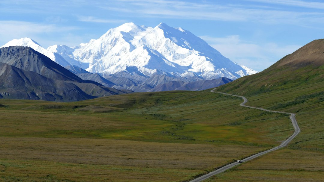
Mount Denali is the highest mountain in North America, a 20,310-foot granite massif in the middle of Alaska's Alaska Range. It rises about 18,000 feet from a base near 2,000 feet above sea level, which the National Park Service notes makes it a mile taller from base to summit than Everest. It is also a mountain with two names. Since January 2025 the federal government has called it Mount McKinley, while Alaska and the national park around it still say Denali.
This guide covers the peak itself: how tall it really is, where the name stands in late 2026, and how it formed. It also covers who climbs it and what happened on the mountain this year. Last comes the question most visitors care about: from where can you see it, and how much of it is actually visible from each spot?
Mount Denali at a Glance
Mount Denali's key numbers come from a 2015 GPS survey of the summit and from National Park Service records.
| Fact | Figure |
|---|---|
| Elevation (South Peak) | 20,310 ft (6,190 m), 2015 GPS survey |
| North Peak | 19,470 ft (5,934 m) |
| Rise from surrounding lowlands | About 18,000 ft |
| Location | Central Alaska Range, about 133 mi north-northwest of Anchorage |
| Official federal name | Mount McKinley (since January 2025) |
| Name used by Alaska and the park | Denali |
| First ascent | June 7, 1913 |
| 2026 climbing season | 976 climbers, 582 summits (60%) |
| Longest glacier on its flanks | Kahiltna Glacier, 44 mi |
How Tall Is Mount Denali?
Mount Denali is 20,310 feet (6,190 m) tall, a figure set by a GPS survey team that reached the summit in June 2015. The U.S. Geological Survey announced the result on September 2, 2015. It replaced the 20,320 feet that had stood since a 1950s photogrammetric survey.
The new number has an odd backstory. In 2013, a radar mapping survey (IFSAR) of Alaska put the summit at just 20,237 feet, 83 feet lower than the published figure. Airborne radar maps broad terrain well but, as the USGS put it, does not provide precise spot elevations. So a team including the University of Alaska Fairbanks and the survey firm CompassData carried GPS receivers to the top to settle it. The answer landed between the two older numbers: 10 feet shorter than the 1950s value, and 73 feet taller than the radar figure.
Height above sea level is only part of what makes the mountain extreme.
Base-to-Peak Rise
The base-to-peak number is the one people remember. According to the National Park Service's geology overview, Denali's base sits around 2,000 feet above sea level, so the mountain climbs roughly 18,000 feet in one sweep. Everest, at 8,848.86 m (29,032 ft), is about 8,700 feet higher above sea level, but it starts from a plateau that is already high. That is why Denali looks so enormous from the tundra. Compare it with Mt. Rainier's 14,411 feet or Mount Fuji's 12,389 feet: both are big volcanoes, but neither stands in front of you the way Denali does from Wonder Lake.
Why Denali Climbs Like a Higher Mountain
At 63 degrees north, the atmosphere is thinner than it is near the equator. A review of altitude physiology notes that the barometric pressure on Denali's summit matches the pressure on a peak of about 6,900 meters in the Himalaya. To a climber's lungs, the mountain behaves as if it were roughly 2,300 feet taller than it is.
Denali or Mount McKinley? The Name in 2026
The mountain's official federal name is Mount McKinley, while the national park and the State of Alaska still call it Denali. Which name you see depends on who made the sign.
The history runs like this:
- Before 1896: Alaska Native peoples had their own names for the peak. The National Park Service's page on the mountain's names records names from nine Alaska Native groups. "Denali" comes from the Koyukon word deenaalee, meaning "the tall one."
- 1897: Gold prospector William Dickey, an admirer of President-elect William McKinley, used the name Mount McKinley in a New York Sun article.
- 1917: Mount McKinley National Park was established on February 26.
- 1975: Alaska asked the federal Board on Geographic Names to adopt Denali. Ohio's congressional delegation blocked the change for four decades.
- 1980: The Alaska National Interest Lands Conservation Act renamed the park Denali National Park and Preserve.
- 2015: President Barack Obama and Interior Secretary Sally Jewell restored Denali as the official federal name.
- January 20, 2025: Executive Order 14172 ordered the name changed back. Interior's Secretarial Order 3424 followed on February 14, 2025. The federal names database (GNIS) now lists the summit as Mount McKinley.
Congress has considered reversing it. A Senate bill to restore Denali (S. 573) was introduced on February 13, 2025. A provision in the Senate's 2026 Interior spending bill would have blocked funding for any name other than Denali. According to a Congressional Research Service report updated September 15, 2026, that provision was left out of the final FY2026 Interior appropriations law. As of October 2026, federal maps say McKinley.
In practice, you will see both. NPS climbing pages and permits now say "Mount McKinley." The park, its visitor centers and its bus system are still "Denali." Most Alaskans never stopped saying Denali. This site uses Denali, the name Alaska uses, and lists McKinley alongside it.
Where You Can See Mount Denali From
You can see Mount Denali on a clear day from Talkeetna, from the Parks Highway, from inside the national park, and from as far away as Anchorage and Fairbanks. But distance changes more than its size in the sky. It decides how much of the mountain is hidden behind the curve of the Earth.
We worked out the geometry for the best-known viewpoints. The calculation uses straight-line distance to the summit, the viewpoint's ground elevation from the Open-Meteo elevation service, and standard atmospheric refraction. "Hidden by curvature" assumes flat ground in between, so foothills can hide more. Seattle's view of Rainier and Tokyo's view of Fuji are included for comparison.
| Viewpoint | Distance to summit | Summit height above horizon | Hidden by curvature | Visible |
|---|---|---|---|---|
| Talkeetna riverfront | 59 mi | 3.3° | ~660 ft (3%) | Nearly all of it |
| Wasilla | 114 mi | 1.2° | ~4,600 ft (23%) | Upper 15,700 ft |
| Anchorage (Point Woronzof or downtown) | 133 mi | 0.8° | ~8,100 ft (40%) | Upper 12,200 ft |
| Fairbanks (UAF campus) | 157 mi | 0.4° | ~8,900 ft (44%) | Upper 11,400 ft |
| Mt. Rainier from Kerry Park, Seattle | 61 mi | 2.1° | ~700 ft (5%) | Nearly all of it |
| Mt. Fuji from Tokyo Station | 63 mi | 1.8° | ~1,700 ft (14%) | Upper 10,600 ft |
Two things stand out.
From Anchorage and Fairbanks, the curve of the Earth hides the lower 40% of Denali's height. What you see is the upper 11,000 to 12,000 feet: the snowy summit massif, sitting low on the horizon. From Fairbanks, the summit stands less than 0.4 degrees above the horizon, which is narrower than the full moon is wide. Even so, the snowy massif still stands out on the skyline on a clear day.
Talkeetna is a different experience. At 59 miles it gives a Seattle-style view of Rainier: almost the whole mountain, from the foothills to the summit, filling 3.3 degrees of sky. That is why Talkeetna is the reference point for our live Denali visibility checker. In theory, from sea level and with nothing in the way, the summit clears the horizon out to about 188 miles.
Inside the park, the views get closer. Wonder Lake sits about 26 miles from the summit, the closest point on the road. The park road has been closed past Mile 43 since 2021. A new bridge over the Pretty Rocks landslide opened to hikers and cyclists on August 27, 2026, and public bus service to the west end of the road is expected to resume in 2027. The Wonder Lake guide and the Denali National Park guide cover access in detail.
If you are choosing between a bus and a flight, the Denali tour comparison lists the summit angle from each bus stop and roadside viewpoint.
Why Mount Denali Hides in Cloud
Mount Denali is hidden by cloud on most days. The NPS photography page passes along a rule of thumb from veteran bus drivers that only one day in three offers even a glimpse. The mountain is so tall that it reaches into air masses well above everything around it. Moist air from the Gulf of Alaska rises against the range, cools and condenses. The result is cloud that clings to the summit even when Talkeetna or Anchorage is sunny.
The season matters more than most visitors expect. We pulled ten years (2016 to 2025) of modelled hourly cloud cover for the grid cell over the summit from Open-Meteo's historical weather archive (its default blended reanalysis). We then counted the days, in Alaska time, that had at least three straight daylight hours with cloud cover at 30% or less. Ranked from best to worst:
- Best: April (42% of days), then March (34%)
- Middle: February (29%), January, May and November (28%), June and December (25%), October (24%), September (22%)
- Worst: July (19%), August (16%)
These are model estimates for one grid cell, not observations from the ground, and small changes in the method shift the winter months by several points. The broad pattern is steadier: July and August come out cloudiest, and March and April clearest. Around the winter solstice the park gets only about four and a half hours of daylight, which is why spring, with long days and the best modelled odds, is the sweet spot.
Cloud on the summit is not the only problem, either. Clouds anywhere along a 133-mile line of sight can block the view from Anchorage. That is why a sunny Anchorage morning does not guarantee a view. The live score on the /denali page combines cloud cover, humidity, precipitation and visibility using our weighted atmospheric model.
The Denali webcams roundup shows how to confirm with your own eyes before you drive anywhere.
How Mount Denali Formed
Mount Denali is mainly granite that cooled deep underground and has since been pushed miles into the sky. The NPS geology overview describes the granite as less dense than much of the surrounding rock, so over millions of years it floats slowly upward, like a cork held under water.
Two features explain the height. First, the granite resists erosion, so uplift outpaces weathering. Second, a large bend in the Denali Fault directly north of the mountain makes the rocks bunch up. That compression is still active: the NPS gives an uplift rate of about half a millimeter per year.
Unlike Rainier or Fuji, Denali is not a volcano. There is no eruption risk, only ice. According to the NPS glaciers page, at least 40 named glaciers flow off the mountain. The Kahiltna Glacier, 44 miles long, is the longest in the park and in the whole Alaska Range, and it carries the base camp most climbers fly into.
Climbing Mount Denali
Climbing Mount Denali takes about three weeks on the West Buttress route, and historically a bit over half of climbers reach the summit. The NPS historical timeline records 108 of 203 in 1973 (53%) and 775 of 1,340 in the record year of 2005 (58%). According to the NPS 2026 season wrap-up, 976 climbers registered and 582 reached the top, a 60% success rate. These are preliminary numbers, and the park advises planning a trip of at least three weeks.
It was also a deadly season. Five climbers died on the West Buttress, all between late May and early June. One of them was NPS climbing ranger Robin Pendery, who fell into a crevasse near the 14,000-foot camp on June 4. The Anchorage Daily News reported that she was the first member of the climbing ranger corps to die in more than 25 years. Three members of a Latvian team died in a fall near Denali Pass, at about 18,200 feet, on May 27.
First Ascents
The first ascent of the South Peak came on June 7, 1913, by Hudson Stuck, Harry Karstens, Walter Harper and Robert Tatum. Harper, who was Alaska Native, was the first to set foot on top. Three years earlier, the 1910 "Sourdough" expedition of local miners climbed the lower North Peak (19,470 feet) via the Muldrow Glacier and planted a spruce pole near the top. Frederick Cook's 1906 summit claim drew skepticism from the start, partly because he said the climb took just eight days. Bradford Washburn's party pioneered the West Buttress in 1951, and it is now the route almost everyone uses.
Permits and Logistics
Every climber must register with the park at least 60 days before starting. The mountaineering special use fee for 2026 was $450, or $350 for climbers aged 24 and under, plus the $15 park entrance fee. Climbers fly from Talkeetna to Kahiltna Base Camp on the glacier. The season runs from May into July.
The Cold
The weather is the real hazard. An automatic weather station at Denali Pass, at about 18,750 feet (5,715 m), ran intermittently from 1990 to 2007. A study of its records found air temperatures down to about −60°C (−76°F) and wind speeds above 60 meters per second (about 134 mph).
Frequently Asked Questions
Is Mount Denali the same as Mount McKinley?
Yes. They are two names for the same peak. Mount McKinley is the official federal name since January 2025. Denali is the name used by Alaska, by the national park, and by the Koyukon people whose word it comes from.
Is Mount Denali taller than Everest?
No. Everest is 29,032 feet above sea level, about 8,700 feet higher than Denali. But Denali rises about 18,000 feet from its base, more than Everest rises above the Tibetan Plateau. So it looks bigger from its own surroundings.
Can you see Mount Denali from Anchorage?
Yes, on clear days, from spots like Point Woronzof and the Tony Knowles Coastal Trail. The summit is 133 miles away and sits less than a degree above the horizon. The curve of the Earth hides roughly the lower 8,000 feet of the mountain.
How long does it take to climb Mount Denali?
Plan on about three weeks for the West Buttress; the park advises a trip of at least three weeks because Alaska Range weather is so unpredictable. Climbers must register at least 60 days in advance.
The Bottom Line on Mount Denali
Mount Denali is 20,310 feet tall and officially named Mount McKinley in federal records. Much of the time it is hidden in cloud. The height and the name have clear answers. Visibility is the part that changes hour to hour, and it can go from total cloud to a sharp, bright summit within one afternoon.
If you are planning around a view, the time of year matters most: in the modelled data, April and March beat July and August by a wide margin. On any given day, the place to start is the Denali visibility forecast, which scores current conditions from Talkeetna.
If you collect big mountains, the same live approach works for Rainier from Seattle and Fuji from Tokyo.
More Articles
Denali National Park Guide: Road, Seasons and Mountain Odds
Denali National Park guide with 2026-27 road access, fees, and 10 years of cloud data showing which months give you the best shot at seeing the mountain.
Denali Tour Guide: Which Bus or Flight Shows the Mountain?
Every Denali tour compared: bus tours, flightseeing, prices, refund rules, and how close each one gets you to the mountain in 2026 and 2027.
Wonder Lake Denali: Iconic Reflection Views and 2026 Access Guide
Wonder Lake Denali has the park's most iconic mountain reflection, but the road is closed past Mile 43. What to know before visiting in 2026-2027.