Christine Falls at Mount Rainier: Bridge, Parking and Views
Christine Falls drops 69 feet in two tiers under a 1928 stone bridge on the road to Paradise. Where to park, how to see both tiers, and when to go.

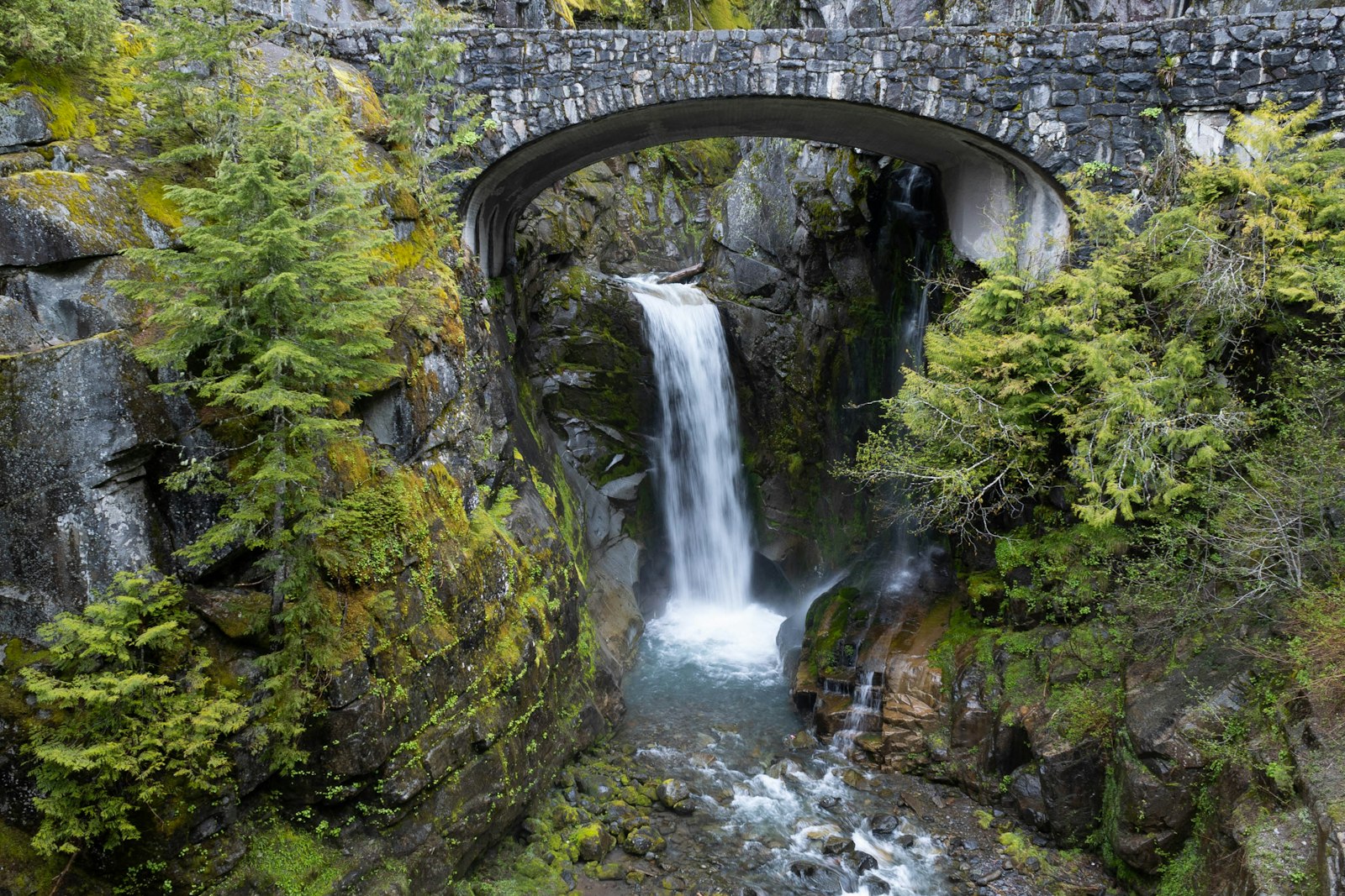
Christine Falls is a two-tier waterfall on Van Trump Creek in Mount Rainier National Park, right beside the road from Longmire to Paradise. Its lower drop pours through the arch of a stone-faced bridge built in 1928, which makes it a classic photo stop on the Paradise road. You can see it from a fenced overlook a minute's walk from the car, and it looks good in any weather.
That last part matters. Mount Rainier hides behind cloud on most days, and the live Mount Rainier visibility score tells you whether today is a summit day or a waterfall day. On a waterfall day, Christine Falls is the easiest stop on the whole Paradise road.
Christine Falls at a Glance
Christine Falls drops about 69 feet in two tiers: 32 feet above the road bridge and 37 feet below it.
| Christine Falls | |
|---|---|
| Height | About 69 ft total, in drops of 32 and 37 ft (World Waterfall Database); the NPS says 60 ft |
| Stream | Van Trump Creek, glacier-fed, flows south to the Nisqually River |
| Elevation | About 3,700 ft |
| Location | 4.5 mi east of Longmire, about 11 mi from the Nisqually Entrance |
| Walk | A short path and steps from the pullout to the overlook below the bridge |
| Parking | Two small pullouts, one on each side of the bridge |
| Season | Open all year when the Longmire-Paradise road is open |
| Entry | Park entrance fee, $30 per vehicle for 7 days; no timed entry in 2026 |
The two height figures come from what gets counted. The NPS rounds the falls to a single 60-foot plunge, while the waterfall databases add up both tiers. Neither counts the cascades in the slot canyon below.
How to See Both Tiers
You can't see both tiers of Christine Falls from one place. The bridge deck sits between them, so each viewpoint shows one tier well and the other badly or not at all.
The lower tier (the famous view). Park in the pullout on the downhill (Longmire) side of the bridge and take the short path and steps down to the fenced overlook. You face upstream, roughly north, with the 37-foot lower drop falling through the bridge arch. The NPS calls this the best view. The path was laid out in the 1930s, and the NPS history page says Civilian Conservation Corps crews helped build it.
The upper tier. The 32-foot upper drop sits above the road, in a tight gorge. From the bridge itself you look down at it. The bridge is narrow and busy, and the NPS warns visitors to watch for cars, so stay off the roadway and keep children close.
From above. The Comet Falls trail starts a quarter mile west along the road. At 0.3 mile it crosses Van Trump Creek on a solid footbridge, and WTA notes that from the middle of it you can glimpse the road below Christine Falls. The trailhead lot only holds about 16 cars.
For photographers. The gorge is tight, and the World Waterfall Database calls the two tiers hard to get in one frame without an ultra-wide lens. Overcast light works best. The overlook faces north, so on a sunny day the sun is behind you and lights the falls in patches against deep shadow, which is hard to expose. Drones are banned throughout the park.
Can You See Mount Rainier From Christine Falls?
Not from the falls or the bridge. The summit is only about 5 miles away, but the gorge walls and a ridge to the north hide it.
We checked the line of sight with a bare-earth terrain model, the same method we used for the Comet Falls trail. From the bridge and the falls themselves, the walls of the gorge block everything. From the overlook and the downhill pullout, a ridge about 0.4 to 0.5 mile north hides the summit, though only by a narrow margin, so treat that result as approximate. From the uphill pullout, the model shows the top of the mountain just clearing that ridge. The model has no trees, and the pullout is in tall forest, so expect the view to be blocked there too. If you could see through the ridge, the summit would sit about 23 degrees above the horizon.
For a mountain view nearby, drive about 7.5 miles up to Paradise, or hike up into Van Trump Park above Comet Falls when the summit is clear.
When the Mountain Hides, Christine Falls Is the Stop
Christine Falls is at its best on days when Mount Rainier is hidden, and those are most days of the year. A waterfall in a mossy gorge photographs better under flat gray light than in midday sun.
To put numbers on it, we pulled ten years (2016 to 2025) of hourly modeled weather from the Open-Meteo historical archive: cloud cover over the summit, and precipitation and snowfall at a model cell near the falls at about the same elevation. Each day went into one of three groups, using the 9 AM to 4 PM window that matches winter gate hours:
- Mountain day: at least three hours in a row with summit cloud cover at or below 30%.
- Waterfall day: no clear summit window, and under 1 mm of precipitation at the falls in that window.
- Wet day: no clear summit window, and 1 mm of precipitation or more.
The last column counts days with at least 1 cm of modeled new snow at the falls.
| Month | Mountain day | Waterfall day (hidden, dry) | Wet day | Snow fell |
|---|---|---|---|---|
| January | 15% | 39% | 46% | 55% |
| February | 15% | 37% | 47% | 58% |
| March | 17% | 40% | 43% | 51% |
| April | 20% | 44% | 35% | 36% |
| May | 20% | 48% | 31% | 12% |
| June | 28% | 45% | 27% | 4% |
| July | 61% | 31% | 8% | 0% |
| August | 57% | 35% | 8% | 0% |
| September | 42% | 41% | 18% | 2% |
| October | 30% | 36% | 34% | 16% |
| November | 19% | 36% | 45% | 39% |
| December | 16% | 37% | 47% | 59% |
Across the year, about 28% of days had a clear summit window and about 39% were dry with the summit hidden. Only July, August and September had more mountain days than waterfall days, and September only barely. From October to June, the summit was clear on 15% to 30% of days, and dry, hidden days were more common than mountain days in every one of those months.
These are model grid cells several kilometers across, not measurements at the falls, so treat the table as rough historical odds, not a forecast.
The practical plan is simple. On a high-score morning on the Rainier visibility page, drive straight to Paradise and Reflection Lakes while the summit is out, and stop at Christine Falls on the way down. On a low-score day, make Christine Falls, Narada Falls and Comet Falls the plan. The score comes from our weighted atmospheric model, and the Rainier webcams show the summit directly before you commit to the drive.
Parking and Getting There
Christine Falls is on the Longmire-Paradise road, 4.5 miles east of Longmire and about 7.5 miles below the Jackson Visitor Center at Paradise. Driving uphill, you pass the Comet Falls trailhead lot, then reach the bridge a quarter mile later.
The NPS describes a small pullout on each side of the bridge. Both are small and can fill on busy summer days, but most stops here are short, so spaces turn over quickly. Don't take a space in the Comet Falls lot for a quick waterfall stop, because hikers need it for half a day.
Narada Falls is a few miles farther up the road. The park doesn't require timed-entry reservations in 2026. The entrance fee is $30 per private vehicle, valid for seven days, and the Mount Rainier entrance fee guide covers passes. The nearest beds are at Longmire's National Park Inn, about 4.5 miles away, and the Mount Rainier lodging guide covers Ashford and the other gateway towns.
Christine Falls in Winter (and This Week)
You can see Christine Falls from the road all winter, but only during the hours the Longmire gate is open. The falls sit above the gate, on the stretch of road the park closes every night in winter.
As of the NPS road status page updated October 29, 2026, nightly closures have started for the season. When conditions allow, the gate opens at 9 AM, the uphill gate closes at 3 PM, and the downhill gate closes at 4 PM. The gate can open late or stay closed all day after a storm. Every vehicle in the park must carry tire chains from November 1 to May 1, four-wheel drive included.
The NPS warns that the path to the lower overlook can be very icy and hazardous in winter. The snow column in the table above shows why. In the model, snow fell at the falls on more than half of all days from December to March. If the path is icy, skip the steps; the NPS notes the falls can still be seen from the road.
Winter is also when the falls carry the most rain. The model put about 335 to 390 mm of precipitation a month on the falls from November to January, against 24 mm in July. Van Trump Creek is glacier-fed, so it keeps running through dry summer spells.
The Creek That Reshaped the Falls
Christine Falls has changed shape in the last 25 years because Van Trump Creek carries debris flows and floods.
On the evening of August 14, 2001, meltwater diverted from the Kautz Glacier set off debris flows that swept down Van Trump Creek to the Nisqually River, according to a USGS study of the event. The largest one ran down Comet Falls, through the gorge at Christine Falls and on beyond the Wonderland Trail footbridge near Cougar Rock. The World Waterfall Database reports that the flow coated the canyon in mud and debris and knocked a large rock out of the upper tier, while the lower tier kept its shape. It also says later floods in 2003 and, especially, 2006 scoured the creek bed down to bedrock.
The November 2006 storm dropped about 18 inches of rain in 36 hours, according to the NPS flood summary, and the damage closed the park for six months; it reopened on May 5, 2007. If the creek suddenly turns muddy or rises, or you hear a roar upstream, move away from the channel. The Mount Rainier weather guide explains the heat waves and atmospheric rivers behind these events.
The Christine Falls Bridge
The Christine Falls Bridge is a reinforced concrete arch faced with native stone. It was finished in 1928 and listed on the National Register of Historic Places in 1991.
The NPS calls the site "an outstanding work of naturalistic landscape architecture." It is the third bridge here. A wooden bridge crossed the creek downstream of the falls in 1907, and in 1915 the road was moved and a new bridge built in the current spot. The present span, a granite-faced concrete arch, replaced it in 1927 and 1928. The stone facing is the NPS Rustic style, meant to make park structures blend into the landscape.
The pullouts and their big rock retaining walls date from around 1928 and 1941, and the site is part of the Mount Rainier National Historic Landmark District.
Who Was Christine?
The falls are named for Christine Louise Van Trump, daughter of Philemon Beecher Van Trump. With Hazard Stevens, he made the first documented ascent of Mount Rainier in 1870. Van Trump Creek, Van Trump Park and the Van Trump Glacier upstream are named for him.
Christine went up the mountain herself as a child. In 1889, at age nine, she climbed with her father to roughly 10,000 feet despite a crippling nervous disorder, according to the World Waterfall Database and Wikipedia. Sources disagree on who named the falls. Visit Rainier credits her father. A park Nature Notes item says John Hayes of Yelm named them.
This guide covers Mount Rainier's waterfall. There's also a Christine Falls in the Adirondacks near Speculator, New York, and Christine Falls is a 2006 crime novel by Benjamin Black.
Before You Go
Christine Falls takes ten minutes, needs no hike and works in fog and drizzle, so it belongs in almost any Mount Rainier National Park day on the south side. Check today's Rainier visibility first, so you know whether to save the falls for the drive down or make them the main event, and check the gate hours from November to April.
More Articles
Narada Falls: Mount Rainier's Roadside Waterfall Guide
Narada Falls is Mount Rainier's largest drive-up waterfall. Get directions, the trail, the best time to visit, and rainbow-viewing tips.
Comet Falls Trail at Mount Rainier: Height, Hike and Views
Comet Falls drops 301 feet in one plunge, 1.9 miles up a steep Mount Rainier trail. Trail stats, parking, the real height, and when to go higher.
Paradise Mt Rainier: The Complete Visitor Guide for Every Season
Plan your trip to Paradise at Mt Rainier with trail details, parking tips, wildflower timing, and visibility forecasts.