Mount Rainier National Park Guide: Seasons, Areas and Odds
Mount Rainier National Park guide: fall 2026 closures, fees, the five park areas, and 10 years of cloud data on when you will actually see the mountain.
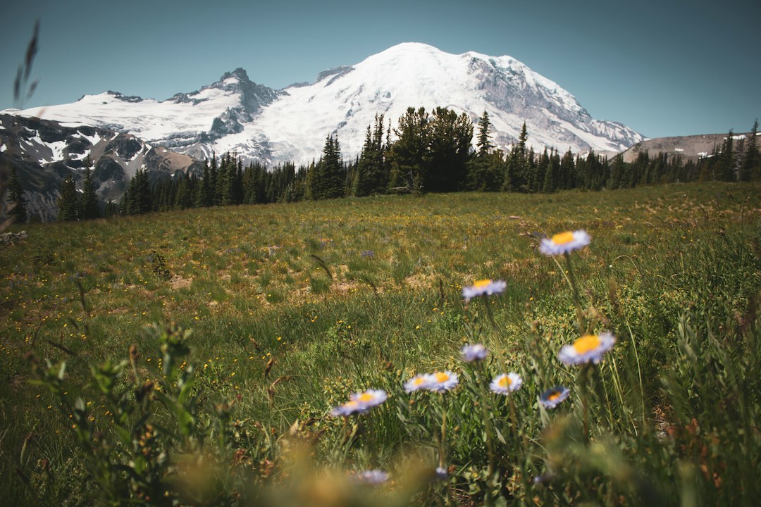
Mount Rainier National Park protects a single volcano and everything that drains off it: 28 major glaciers, old-growth forest in the valleys, and subalpine meadows that bloom for a few weeks each summer. It sits about 60 miles southeast of Seattle, and the 14,411-foot peak is the reason most of its 1.6 million annual visitors come.
Whether you see that peak is another matter. Ten years of modeled cloud cover over the summit show a three-hour clear window on roughly three days in four in July, and on about one day in five in winter. This guide covers the park's five areas, what is open and closed as of October 2026, fees and lodging, and month-by-month odds of the mountain being out. It also covers a pattern worth knowing before you cancel a trip: a gray morning in Seattle that turns out to be a clear one at Paradise.
Mount Rainier National Park at a Glance
Mount Rainier National Park covers about 236,000 acres of west-central Washington, charges $30 per vehicle for a 7-day pass, and is open 24 hours a day, all year. Figures below come from the NPS fees page, glacier page and park history.
| Fact | Detail |
|---|---|
| Established | March 2, 1899, the fifth US national park |
| Size | About 236,000 acres (369 sq mi), roughly 97% designated wilderness |
| Summit | 14,411 ft, the highest point in the Cascades (full height story) |
| Glaciers | 28 major glaciers covering about 30 sq mi; Emmons is the largest by area |
| Highest point by car | Sunrise, 6,400 ft |
| 2025 visitors | 1,635,342 recreation visits (Public Lands Data) |
| Entrance fee | $30 per vehicle, $25 motorcycle, $15 per person on foot or bike, all valid 7 days |
| Timed entry | Not required in 2026 |
| Year-round road access | Nisqually Entrance to Longmire, then to Paradise when the winter gate is open |
The mountain is also an active volcano. The USGS dates its most recent well-documented eruptions to about 1,000 years ago, and reports of 19th-century steam eruptions remain unconfirmed (USGS eruption history). Lahars are the main hazard it is monitored for; our Mt. Rainier eruption guide explains what scientists watch for.
What Is Open in Mount Rainier National Park Right Now (October 2026)
In October 2026, Paradise, Longmire and the Stevens Canyon Road are open, while Sunrise Road is closed to cars for the rest of the year and the Carbon River and Mowich Lake areas have no road access at all. Every date below is from the NPS road status page (updated September 28, 2026), the park's alerts and fire information pages, and its hours of operation.
| Area or road | Status | Scheduled seasonal close |
|---|---|---|
| Nisqually Entrance to Longmire | Open | Year-round |
| Longmire to Paradise | Open | Year-round, with a winter gate at Longmire |
| Paradise Valley Road | Open | October 19, 2026 |
| Ricksecker Point Road | Open | October 20, 2026 |
| Stevens Canyon Road | Open | October 26, 2026 |
| White River Road to campground | Open | October 26, 2026 |
| Sunrise Road | Closed to vehicles; open to walkers and cyclists | Rest of 2026 |
| SR 410 Chinook Pass / SR 123 Cayuse Pass | Open | Closes with the first heavy snow |
| Carbon River Road and Mowich Lake Road | Closed | No public road access |
| Paradise Inn | Closed for the season September 28 | Reopens in spring |
| National Park Inn (Longmire) | Open | Year-round |
Three things changed the park map this year:
- Fire in the north. The Grand Park 2 Fire started in August. At the NPS's September 21 update it was 100% contained but still burning, and the Wonderland Complex fires, including Garda Falls and West Fork, were still burning in the north of the park. Trails north of Sourdough Ridge are closed, including Mount Fremont. So is the Wonderland Trail from the Carbon River suspension bridge to Frozen Lake. The hikes guide lists what you can still walk from White River.
- The Fairfax Bridge. Washington State DOT permanently closed the SR 165 bridge near Carbonado on April 22, 2025, after inspections found new deterioration of its steel supports. It was the only public road to Mowich Lake and the Carbon River entrance. WSDOT is now studying two options: a replacement bridge, or keeping SR 165 closed and removing the old one.
- Ohanapecosh is under construction. The campground and visitor center are closed through November 2026. The Grove of the Patriarchs trail stays closed because the suspension bridge to it was damaged in 2021, and the NPS now plans to start building a new bridge in 2028, with reopening projected for 2029. Preparation work closes the Grove of the Patriarchs parking lot from October 5 to 31, 2026 (park construction page).
Winter rules start soon. From November 1 to May 1, the NPS requires every vehicle in the park to carry tire chains, whatever the forecast and whatever you drive.
The Five Areas of Mount Rainier National Park
Mount Rainier National Park has five visitor areas around the mountain: Longmire, Paradise, Ohanapecosh, Sunrise/White River and Carbon River/Mowich. No road circles the peak, so most day trips cover one or two of them.
| Area | Elevation | Typical road season | Known for |
|---|---|---|---|
| Longmire | 2,760 ft | Year-round | Historic district, museum, National Park Inn, forest walks |
| Paradise | 5,400 ft | Year-round (winter gate) | Meadows, Skyline Trail, Paradise Inn, the classic south-side view |
| Ohanapecosh | about 1,900 ft | Late May to early November | Old-growth forest, Silver Falls, the Grove of the Patriarchs |
| Sunrise / White River | 6,400 ft / 4,400 ft | Late June or early July to late September | Highest road, closest car-accessible view of the Emmons Glacier |
| Carbon River / Mowich | about 1,700 ft / 4,930 ft | No road access since April 2025 | Inland temperate rainforest, Mowich Lake |
Longmire and the road to Paradise
Longmire is where the park began: a mineral-spring resort in the 1880s, and now a historic district with a small museum and the year-round National Park Inn. From there the road climbs 12 miles to Paradise, with two stops worth making on the way. Narada Falls is a short, steep walk from its parking lot. Christine Falls is visible almost from the road bridge.
Paradise
Paradise is the park's most visited area and the best single destination if you have one day. The Jackson Visitor Center, Paradise Inn and the wildflower meadows all sit at 5,400 feet, directly under the south face. Trails start from the main lot. Our Paradise guide covers parking, lodging and winter visits. The Skyline Trail guide covers the 5.5-mile loop to Panorama Point, including which way to walk it and when the snow melts out.
A few miles east of Paradise on Stevens Canyon Road, Reflection Lakes is the mirror shot on half the postcards in Washington. It needs a calm morning as well as a clear one.
Ohanapecosh and Stevens Canyon
Ohanapecosh, in the southeast, is low, green and almost free of mountain views. People go there for trees. The Stevens Canyon Road connects it to Paradise through Box Canyon and past the Bench and Snow Lakes trailhead. In 2026, with the campground closed, Silver Falls is the main walk; start it from the Grove of the Patriarchs parking lot, or from the Cowlitz Divide Trailhead on Stevens Canyon Road while that lot is closed in October.
Sunrise and the east side
Sunrise is the highest point you can drive to in the park, and from there the mountain looks bigger and more glaciated than from Paradise. In a normal year the road opens in late June or early July and closes in late September; in 2026 it is closed to cars because of the fires. The Sunrise guide covers the trails and the road. On SR 410 at the park's eastern edge, Tipsoo Lake at Chinook Pass has a roadside reflection of the mountain and the start of the Naches Peak Loop.
Carbon River and Mowich Lake
The northwest corner holds the park's rare inland temperate rainforest and Mowich Lake, the largest and deepest lake in the park. With the Fairfax Bridge closed, the public can't drive to either. Treat this corner as off the map until WSDOT decides what to do with the bridge.
How Often Can You See Mount Rainier From the Park?
In modeled cloud data for 2016 to 2025, about 70% of July and August days had a three-hour clear window over Mount Rainier's summit, compared with about one day in five from November through March. July is the best month, with August a close second.
How we measured it. We pulled hourly cloud cover for 2016 to 2025 from the Open-Meteo historical archive for the model grid cell over the summit, using its default "best match" model. A glimpse day has at least one hour between 7 AM and 7 PM with cloud cover of 30% or less. A clear-window day has three such hours in a row, which is long enough to drive up, park and walk out to a viewpoint. Percentages are shares of all days in that month across the 10 years. These are modeled cloud figures for a grid cell, not reports of whether a person at Paradise saw the summit. Read them as a ranking of months, not a promise. Visitor numbers are 2025 NPS recreation visits.
| Month | Glimpse day | 3-hour clear window | 2025 visitors | Share of year | Visitors per clear-window day |
|---|---|---|---|---|---|
| January | 32% | 22% | 28,052 | 1.7% | about 4,100 |
| February | 33% | 20% | 12,733 | 0.8% | about 2,300 |
| March | 37% | 23% | 23,593 | 1.4% | about 3,300 |
| April | 38% | 27% | 41,504 | 2.5% | about 5,100 |
| May | 53% | 35% | 99,974 | 6.1% | about 9,200 |
| June | 60% | 43% | 251,066 | 15.4% | about 19,500 |
| July | 84% | 74% | 428,242 | 26.2% | about 18,700 |
| August | 82% | 69% | 430,922 | 26.4% | about 20,100 |
| September | 66% | 51% | 168,751 | 10.3% | about 11,000 |
| October | 50% | 38% | 98,921 | 6.0% | about 8,400 |
| November | 33% | 23% | 30,232 | 1.8% | about 4,400 |
| December | 29% | 22% | 21,352 | 1.3% | about 3,100 |
The last column divides each month's visitors by its expected number of clear-window days. It is a rough crowding index: how many other people turn up on each day the mountain is likely to be out.
Two things stand out.
First, the crowds and the clear weather line up. Just over half of 2025's visitors came in July and August, which are also the two clearest months. That is not true at every big mountain park. At Denali, the peak visitor months are among the cloudiest of the year in the same kind of modeled data, as our Denali National Park guide shows. At Rainier, the summer crowd is mostly getting it right.
Second, September is the value month. It keeps a clear window on about half its days, and that rises to 55% in the first half of the month. It draws less than 40% of August's visitors. Per clear-window day, it is about 45% less crowded than August. The meadows are past peak bloom, but in good years the huckleberry and mountain ash turn red across the hillsides, and the parking pressure at Paradise eases.
June is the month to be wary of. It carries 15% of the year's visitors, yet its clear-window rate (43%) is closer to May's than to July's. Snow often covers Paradise into early July, too. In the Paradise SNOTEL snow-depth record for 2011 to 2026, the median date the station's snow depth reaches zero is around July 9, with a range from late May (2015) to late August (2011).
Time of day matters less here than people assume. From July to September, the share of clear summit hours is about 55% through the morning and dips to 47% in mid-afternoon before recovering toward evening. The morning advantage is real but small. What matters more is whether the day starts clear: on July to September days with a clear summit cell at 8 AM, it is still clear at noon about 78% of the time.
A Gray Morning in Seattle Does Not Mean a Gray Day at Paradise
In the modeled 2016 to 2025 data, more than half of July mornings that are overcast in Seattle still give a three-hour clear window at Mount Rainier's summit. Calling off a summer drive because the city looks gray can mean missing a clear day on the mountain.
The likely reason is the marine layer. On summer mornings a sheet of low stratus often fills the Puget Sound lowlands, and it is typically much lower than Paradise. Paradise sits at 5,400 feet, and the summit at 14,411. On those mornings you can drive up through the gray on SR 706 and come out above it on the climb to Paradise, with the cloud below you.
We compared the same 2016 to 2025 model data for the downtown Seattle grid cell at 9 AM against the summit cell for the same day. "Overcast" here means modeled cloud cover of 80% or more; the clear-window test is the same 7 AM to 7 PM, three-hour rule as above:
| Month | Seattle overcast at 9 AM | Of those overcast mornings, summit still got a 3-hour clear window |
|---|---|---|
| May | 62% of days | 18% |
| June | 55% | 28% |
| July | 41% | 55% |
| August | 44% | 52% |
| September | 56% | 34% |
| October | 69% | 26% |
| November to February | 71% to 75% | 9% to 13% |
The lesson is seasonal. From November through February, a gray Seattle morning usually means a frontal system, and the mountain is in it too. In July and August, a gray Seattle morning tells you very little about the mountain. The National Weather Service's Mt. Rainier recreational forecast gives conditions and the freezing level at elevation on the mountain itself. Our live Mt. Rainier visibility score looks at the summit directly, not at the city skyline.
The same logic works the other way round. A clear morning from Kerry Park does not guarantee a clear Paradise afternoon, because the mountain builds its own cap clouds on moist days. The Seattle-side story, and why locals ask "is the mountain out?", is in our guide to seeing Rainier from the city.
Best Time to Visit Mount Rainier National Park
The best time to visit Mount Rainier National Park is late July to mid-August for wildflowers and the clearest weather, or the first three weeks of September for a clear window on about half of days with far fewer people.
- Late July to mid-August: Peak bloom in the Paradise and Sunrise meadows, most trails snow-free, and the highest clear-sky odds of the year. Arrive before 9 AM on weekends; Paradise parking regularly fills by mid-morning.
- September: A clear window on about half of days and roughly 60% fewer visitors than August. Sunrise Road normally stays open until late September. Fall color starts on the slopes late in the month.
- Early October: Quiet and often crisp, with a clear window on about four days in ten. Stevens Canyon and the east side close later in the month, and Paradise Inn has already shut for the season.
- November to April: Paradise is snow country, and by March there are usually 10 feet or more of snow on the ground. Snowshoeing, skiing and the drive to the Longmire gate are the main activities. Chains are mandatory, and the Longmire to Paradise road can close at short notice for storms.
- May and June: The shoulder season with the worst trade-off. Lowland forest trails are open, but the high meadows are still under snow and a three-hour clear window comes on fewer than half of days.
For the full weather picture by month, including snowfall and temperature by elevation, see the Mt. Rainier weather guide.
Getting to Mount Rainier National Park
Mount Rainier National Park is about two hours by car from Seattle and about 1 hour 45 minutes from Sea-Tac Airport, with no public transit to the park. Which entrance you use depends on the area you want to visit.
| Entrance | From Seattle | Leads to | Season |
|---|---|---|---|
| Nisqually (southwest) | About 95 mi, 2 hrs | Longmire, Paradise | Year-round |
| White River (northeast) | About 85 to 95 mi, 2 hrs 15 min | Sunrise, White River | Summer to fall |
| Stevens Canyon (southeast) | About 110 mi, 2 hrs 30 min | Ohanapecosh, then Paradise | Late May to late October |
| Carbon River (northwest) | n/a | Carbon River, Mowich | No road access since 2025 |
Two practical tips. If you want both Paradise and Sunrise in one long day, the connecting route runs through Stevens Canyon Road and SR 123 and takes about 2 hours between the two areas without stops, by the NPS's driving times. And fill the tank before you go: there is no gas station inside the park. Our Seattle to Rainier guide has every route and the weekend traffic times.
Mount Rainier National Park Entrance Fees and Reservations
The Mount Rainier National Park entrance fee is $30 per private vehicle, valid for seven days, and no timed-entry reservation is needed in 2026.
| Pass | Price | Notes |
|---|---|---|
| Private vehicle | $30 | 7 days, everyone in the car |
| Motorcycle | $25 | 7 days |
| Per person (walk-in or bicycle) | $15 | 7 days |
| Mount Rainier Annual Pass | $55 | 12 months, this park only |
| America the Beautiful (US resident) | $80 | All federal fee areas for a year |
| America the Beautiful (non-resident) | $250 | All federal fee areas for a year |
| Senior annual pass | $20 | US citizens or residents 62+ |
The park required timed entry for both the Paradise and Sunrise corridors in 2024, and for the Sunrise corridor only in 2025, then dropped it for 2026. Check the fees page before a 2027 summer trip, since the policy has changed every year recently. Two fee-free days are still left in 2026: October 27 (Theodore Roosevelt's birthday) and November 11 (Veterans Day). In 2026 these free days apply to US citizens and residents only.
Other permits are separate. Overnight backpacking, including the Wonderland Trail, needs a wilderness permit through Recreation.gov. Anyone going onto a glacier or above the high camps at about 10,000 feet needs a climbing permit too.
Where to Stay and Camp
Inside the park, you can choose between two historic lodges and three drive-in campgrounds, one of them closed in 2026. The lodges and Cougar Rock's reservable sites fill early for summer.
- Paradise Inn, built in 1916 and opened in 1917, sits at 5,400 feet (NPS lodging). Staying here means you are already at Paradise at dawn, before the day traffic arrives. It is generally open from May through September and closed for 2026 on September 28 (hours of operation).
- National Park Inn at Longmire is smaller and open all year. It is the only lodging inside the park in winter.
- Cougar Rock Campground, between Longmire and Paradise, has 178 sites at $20 a night, with a typical season of late May to early October, reservable on Recreation.gov (NPS campgrounds).
- White River Campground has 88 first-come sites at $20, usually late June to late September; in 2026 it stays open until October 12. With Sunrise Road closed this year, the campground is still the trailhead for Glacier Basin.
- Ohanapecosh Campground is closed through November 2026 for rehabilitation.
Outside the park, Ashford sits just outside the Nisqually Entrance and has the most cabins and motels. Packwood, on US 12, works for Ohanapecosh and Stevens Canyon. For Sunrise, Greenwater and the Crystal Mountain area on SR 410 are closest. Enumclaw, about an hour out, has chain hotels.
Mount Rainier National Park FAQs
How many days do you need in Mount Rainier National Park? One day covers Paradise and a short hike. Two days lets you do Paradise one day and Sunrise the next, by far the best pairing. With three or more days, add Ohanapecosh and a longer trail such as Skyline or Burroughs. A spare day also helps you wait out a cloudy forecast.
Can you drive to the top of Mount Rainier? No. The highest road in the park ends at Sunrise, at 6,400 feet. Paradise, at 5,400 feet, is the highest point open by car in winter. Reaching the summit is a glaciated climb that needs a climbing permit and usually takes at least two days.
Do you need a reservation to visit Mount Rainier National Park? Not in 2026. You pay the entrance fee at the gate, or use a pass. Timed entry was required in summer 2024 and, for Sunrise, in 2025, so check the NPS fees page each spring before planning a summer trip.
Is Mount Rainier National Park open in winter? Yes, the park is open all year. In winter, cars can reach only Longmire and Paradise through the Nisqually Entrance. The Longmire to Paradise road is gated overnight and closes during storms. Chains are required from November 1 to May 1.
How to Plan a Visit Around the Mountain
Pick your season by the table above, then pick your day by the forecast. Summer gives you good odds, but a summer weekend with low cloud on the summit is still a day of fog at Paradise. The most useful habit is to look at the mountain's conditions, not the city's, the evening before you drive and again at breakfast.
Our Mt. Rainier visibility forecast scores the summit from 0 to 100 using the weighted atmospheric model described on our methodology page, which combines cloud cover at different altitudes, visibility distance, humidity and precipitation. In summer, if the score is high and Seattle is gray, go anyway. There is a good chance you will drive out of the cloud on the way up.
More Articles
Paradise Mt Rainier: The Complete Visitor Guide for Every Season
Plan your trip to Paradise at Mt Rainier with trail details, parking tips, wildflower timing, and visibility forecasts.
Hikes in Mount Rainier National Park: Best Trails by Area
Hikes in Mount Rainier National Park by area, with 2026 closures, snow-free timing and the odds of a clear summit by month and hour.
Mt. Rainier Sunrise: Complete Guide to the Park's Highest Viewpoint
Your complete guide to Mt. Rainier Sunrise: road dates, best hikes, wildflowers, and how to time your visit for clear views of the mountain.