Lake Shoji: Kodaki Fuji, Reflections and How to Visit
How to photograph Kodaki Fuji at Lake Shoji, the smallest Fuji Five Lake, with practical notes on light, weather and access.
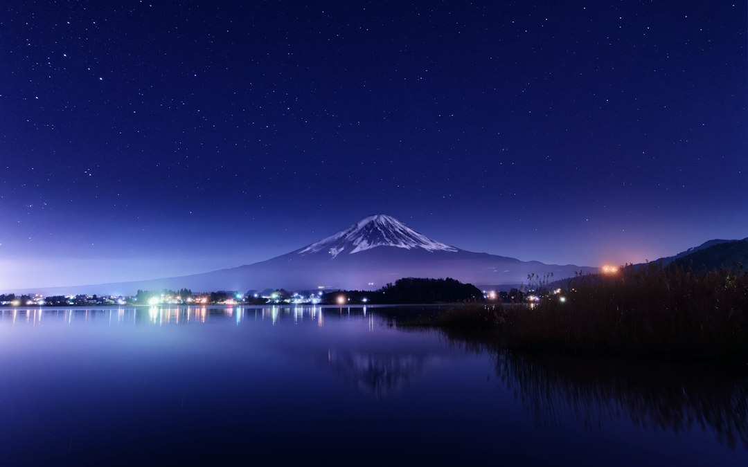
Lake Shoji is the smallest of the Fuji Five Lakes by a wide margin, and many visitors skip it. Its north shore offers Kodaki Fuji, the view in which Mount Omuro appears in front of Fuji like a child in its arms. The lake is sheltered by surrounding mountains, which can make it a rewarding place to look for reflections when the wind is low.
It is also the lake that English-language guides get wrong most often. At least three widely read sites credit Lake Shoji with the reflection engraved on the old 1,000-yen note. That view belongs to Lake Motosu, ten minutes further west.
This guide covers where to see the "Fuji cradling a child" composition, how to improve your chance of a reflection, the lighting trade-off and how to plan a visit.
Table of Contents
- Lake Shoji at a Glance
- Kodaki Fuji: The Composition Only Lake Shoji Has
- How to Look for a Reflection at Lake Shoji
- No, Lake Shoji Was Not on the 1,000-Yen Note
- The Light Problem at Lake Shoji
- When Mt. Fuji Is Actually Out
- The Englishman Who Went Looking for the Best View of Fuji
- Getting to Lake Shoji and What It Costs
- What Else Is Around the Lake
- Frequently Asked Questions
Lake Shoji at a Glance
Lake Shoji covers just 0.5 square kilometres, roughly one thirteenth the surface area of Lake Yamanaka, making it comfortably the smallest of the Fuji Five Lakes. It sits at 900 metres above sea level in Fujikawaguchiko Town, Yamanashi Prefecture, wedged between Lake Motosu to the west and Lake Sai to the east, with the Aokigahara lava plateau along its southern edge.
Here is how it compares against its four neighbours, using the standard Fuji Five Lakes survey figures:
| Lake | Area (km²) | Shoreline (km) | Max depth (m) | Elevation (m) | Transparency (m) |
|---|---|---|---|---|---|
| Yamanaka | 6.80 | 13.87 | 13.3 | 980.5 | 3.7 |
| Kawaguchi | 5.70 | 20.94 | 14.6 | 830.5 | 4.2 |
| Motosu | 4.70 | 11.82 | 121.6 | 900.0 | 12.7 |
| Sai | 2.10 | 9.85 | 71.7 | 900.0 | 6.9 |
| Shoji | 0.50 | 6.80 | 15.2 | 900.0 | 2.8 |
The table describes the lakes' size and water conditions, but those figures alone cannot rank how often each lake produces a photographable reflection. That also depends on wind, the chosen shore and time of day.
The three 900-metre lakes are not a coincidence. Before the year 864 a single body of water called Senoumi filled this basin. The Jogan eruption sent lava down Fuji's northern flank, splitting Senoumi into Motosu, Shoji and Sai, and the three still sit at identical surface levels because they remain connected through the porous lava underground. The same flow cooled into the plateau that became the Aokigahara forest. If you want the full ranking of all five, our Fuji Five Lakes comparison covers the trade-offs.
Kodaki Fuji: The Composition Only Lake Shoji Has
Kodaki Fuji (子抱き富士), meaning "Fuji cradling a child", is the view from Lake Shoji's north shore in which the 1,468-metre parasitic cone of Mount Omuro sits directly in front of Mount Fuji, reading as a small peak held in the larger mountain's arms. It is the single reason to choose this lake over its neighbours.
Most guides stop at that description. The interesting part is why it only works from one small stretch of shoreline, and that comes down to bearings.
From the free prefectural car park at Tatego-hama (他手合浜) on the north-west shore, I calculated the line of sight to both summits from their coordinates:
| From Tatego-hama | Approximate distance | Compass bearing to summit |
|---|---|---|
| Mt. Fuji summit | 18.4 km | 142.5° |
| Mt. Omuro summit | 7.2 km | 141.7° |
The summit bearings differ by less than one degree from this spot, explaining the overlap. The angle of each summit above the horizon is not the mountain's apparent size, so it would be misleading to turn those numbers into a precise "half-height" claim. The composition is easiest to judge by standing on the shore.
Now walk east along the shore and watch it fall apart:
| Position on the north shore | Bearing offset of Omuro from Fuji |
|---|---|
| Tatego-hama car park | 0.8° (centred) |
| 500 m east | 1.1° |
| 1 km east | 3.1° |
| Minshuku village shore | 5.5° |
By the eastern end of the lake the child has slid more than five degrees clear of the parent and you are simply looking at two separate mountains. The composition has a working window of a few hundred metres, and Tatego-hama is the middle of it. That is why every postcard is shot from the same car park.
The car park itself sits at 35°29'31"N, 138°36'15"E, at 911 metres, with around thirty marked spaces, no charge, and a public toilet across the road that asks a ¥50 contribution. It is open around the clock, which matters if you are arriving before dawn.
One thing you cannot do is climb the child. Mount Omuro is the largest of Fuji's parasitic scoria cones, last erupted roughly 3,300 years ago, and has no established trail. It sits inside a national park special protection zone and a wildlife protection area, and its summit is enclosed by forest with no view anyway. Look, do not climb.
How to Look for a Reflection at Lake Shoji
Lake Shoji can produce a Sakasa Fuji reflection when the water is calm. The surrounding hills offer some shelter, but no lake guarantees a mirror: even a light local breeze or boat wake can break the image.
Fetch is the distance wind travels over open water in a particular direction. Lake area is not a substitute for it: two shores on the same lake can behave differently under the same forecast wind. That is why a calculation from lake areas cannot tell you Shoji's ripple height relative to Yamanaka's or Motosu's.
Shoji's mountain-ringed setting is useful context. The Yamanashi prefectural sports facility listing describes the lake as little affected by wind and it is used for canoe racing. That supports trying it on a calm day, not calling it the district's statistically best mirror. Check a local wind forecast, arrive early if you can and look for a sheltered section of the north shore with a clear line to Fuji.
The water's transparency does not establish that Shoji reflects Fuji better than clearer lakes. Reflection quality depends heavily on surface smoothness, light and camera position; a darker-looking surface is not proof of a stronger mirror image.
No, Lake Shoji Was Not on the 1,000-Yen Note
The Mount Fuji reflection engraved on Japanese banknotes was photographed at Lake Motosu from the Nakanokura Pass, not at Lake Shoji. Several English travel sites state otherwise, and the error has propagated widely enough that visitors turn up at Tatego-hama expecting to match a banknote to the view.
The source image is Okada Koyo's photograph Kohan no Haru, taken on 2 May 1935 above Lake Motosu's south-western shore. It ran on the Series D 5,000-yen note from 1984, moved to the Series E 1,000-yen note in 2004, and left circulation when the Bank of Japan issued the Series F notes on 3 July 2024. The new 1,000-yen note shows Hokusai's Great Wave on the reverse.
None of that is a knock on Lake Shoji. It just means the two lakes offer genuinely different pictures, and confusing them costs you the one that is actually here. Motosu gives you a wide, deep bowl seen from an elevated pass after a half-hour climb. Shoji gives you Kodaki Fuji at water level, thirty seconds from a car park.
The Light Problem at Lake Shoji
Lake Shoji looks at Mount Fuji from the north-west on a bearing of about 143 degrees, which means the mountain is backlit at sunrise and best lit in the late afternoon. This inverts the standard advice to shoot Fuji lakes at dawn, and it is worth understanding before you set an alarm.
Run the solar positions for 35.5°N and the pattern is clear. At the winter solstice the sun rises at an azimuth of about 120 degrees, some 22 degrees to the left of the mountain and effectively behind it, so Fuji reads as a flat blue silhouette against a bright sky. The sun does not cross the mountain's bearing until roughly 09:10, by which time it is 20 degrees up and the light is ordinary.
Late afternoon is the opposite. By 16:00 in December the sun sits at 236 degrees and 5 degrees above the horizon, raking almost side-on across the north-west face you are looking at, picking out every gully and snow band. The half hour before sunset is when this lake performs.
There is a related consequence: Lake Shoji does not get Diamond Fuji. The alignment needs the sun to rise or set on the summit, and from Tatego-hama the summit sits at 143 degrees, far south of the 120-degree maximum that sunrise ever reaches at this latitude. For the sunrise diamond you need Ryugatake above Lake Motosu, where it runs from roughly 3 December to 9 January. For the sunset version you need the eastern lakes.
Lake Shoji has two useful windows with different trade-offs. Dawn may offer calmer water and mist but can leave Fuji backlit. Late afternoon can light the mountain more directly, while wind may disturb the surface. Neither window guarantees both a clear summit and a reflection. Our Mt. Fuji photography guide covers exposure for both cases, and the Mt. Fuji sunset guide compares the west-side viewpoints.
If you only get one visit, take the afternoon.
When Mt. Fuji Is Actually Out
Mount Fuji is far more likely to be visible from Lake Shoji on a cold, dry winter day than during the summer, and across the year the summit is hidden or partly capped more often than it is clear. A calm lake with no mountain above it is just a pond.
That seasonal pattern is what our weighted atmospheric model tracks: cloud cover, atmospheric visibility distance, humidity and precipitation combined into a single score. Winter high pressure behind a cold front produces the crispest air of the year. The June to July rainy season and summer convection produce the worst, and on Fuji's northern flank the cloud often builds from late morning.
| Season | Visibility tendency | What Lake Shoji offers |
|---|---|---|
| Winter (Dec–Feb) | Best | Snow to the treeline, sharpest air, near-empty shoreline |
| Spring (Mar–May) | Mixed | Haze builds; fresh green on Omuro against a white summit |
| Summer (Jun–Aug) | Poorest | Canoe season, cool at 900 m, mountain frequently gone |
| Autumn (Sep–Nov) | Improving | Colour on the surrounding ridges, clearing air, calm dawns |
Lake Shoji has one weather-specific weakness worth planning around. Because you are looking at Fuji over the Aokigahara plateau with no built foreground, a partly capped summit ruins the picture completely. There is nothing else in the frame to carry it. On a low-scoring day the neighbouring lakes at least give you caves, villages and museums, whereas Shoji gives you a quiet lake and a very old tree.
Check the score the night before on our live Mt. Fuji dashboard, and confirm in the morning with the webcam feeds. For the month-by-month breakdown, see our guide to the best time to see Mt. Fuji.
The Englishman Who Went Looking for the Best View of Fuji
In 1895, a naturalised British resident of Japan named Harry Stewart Whitworth spent a year circling the base of Mount Fuji searching for the place where the mountain looked best. He chose Lake Shoji, settled there permanently, and built the Shoji Hotel.
I find this the most satisfying fact about the lake, because it is the same question this site exists to answer, asked 130 years earlier with a great deal more walking. Whitworth, who took the Japanese name Hoshino Yoshiharu, then promoted the place across Europe as "Japan Shoji". The local tourism association's history records the result: from the late Meiji period through Taisho and into early Showa, Lake Shoji became one of Japan's premier summer retreats for foreign visitors, and his hotel one of the country's classic Western-style resort hotels.
Meiji-era English visitors gave the surrounding landscape the nickname that Yamanashi's official tourism site still uses, the "Switzerland of East Asia". The Panorama-dai viewpoint above the lake became the standard excursion, roughly an hour away, reached on horseback or in a four-man sedan chair. The lake's fame reached far enough that when the future Emperor Showa visited England as Crown Prince, his hosts asked him about Shoji.
Then the road network reoriented around Kawaguchiko, the crowds followed, and Shoji went quiet. It has stayed that way, which is now the point of coming.
Getting to Lake Shoji and What It Costs
Lake Shoji is about 40 to 50 minutes by bus from Kawaguchiko Station on Fujikyu's Blue Line, the Narusawa, Shojiko and Motosuko sightseeing route, which also serves the Fuji Shibazakura Festival site. By car it is roughly 25 minutes west of Kawaguchiko on Route 139 and then Route 358.
The fare arithmetic is the part worth planning. A single ride out to the Lake Shoji stops costs somewhere around ¥1,300 depending on where you get off, so a return trip is near ¥2,600. The Fujikyu sightseeing bus free coupon covering the Red, Green and Blue lines is ¥1,500 for adults and ¥750 for children for one day, or ¥2,000 and ¥1,000 for two. The day pass therefore beats a simple return by well over ¥1,000, and it lets you break the journey at Lake Sai, the lava caves or Lake Motosu without paying again. Buy it at the Kawaguchiko Station bus window, open 06:30 to 19:00.
Two warnings. Blue Line service is genuinely sparse, roughly every one to two hours, so a missed bus costs you most of a morning. And no scheduled bus will get you to Tatego-hama for a winter sunrise. If dawn is the plan, drive or stay overnight.
From Tokyo, treat Kawaguchiko Station as the hinge point: highway bus or the Fuji Excursion train from Shinjuku, then the Blue Line west. Door to door is around three hours.
What Else Is Around the Lake
There is not much here, and that is the honest summary. Plan Lake Shoji as a two-hour stop or a quiet overnight, not a full day.
The Shoji great cedar. In the grounds of Suwa Shrine on the north shore stands a cedar roughly 1,200 years old, 40 metres tall, with a girth of about 10 metres at chest height and 12.6 metres at the base. It has been a nationally designated natural monument since 31 January 1928 and is the largest tree in Yamanashi Prefecture. It is also, give or take a few decades, the same age as the lava flow that made the lake, which is a quietly astonishing thing to stand next to.
Panorama-dai. The classic hike, and the one Whitworth's guests were carried up. Start from the Panorama-dai-shita bus stop at the western end of the lake and allow around 75 minutes of steady climbing to a ridge with Fuji, the Aokigahara sea of trees and several of the lakes laid out below. Continuing to Mount Sanpobunzan from the Tatego-hama trailhead makes a longer loop.
The Aokigahara edge. The historic Shojiguchi climbing route to Fuji's fifth station begins at Akaike, just east of the lake, and runs almost entirely through forest past lava tree moulds and old parasitic cones. It is a serious full-day undertaking rather than a stroll. Our guide to Aokigahara covers the forest itself and the marked trails within it.
On the water. Canoe and kayak sessions run through the warm months, and the shelter that makes the lake a racing venue also makes it forgiving for beginners. Fishing is permitted.
The Hot Spot bench. The Nippon TV drama Hot Spot, broadcast January to March 2025, was set here, with the Shoji Mount Hotel standing in for the fictional Lake Hotel Asanoko. A bench recreating one of the show's conversations has been installed on the shore and now draws a steady trickle of visitors, and the local Ryoko summer festival was revived in August 2025 after a six-year gap on the back of the attention.
Frequently Asked Questions
What is Lake Shoji famous for?
Lake Shoji is famous for Kodaki Fuji, the "Fuji cradling a child" view in which the 1,468-metre cone of Mount Omuro appears directly in front of Mount Fuji when seen from the lake's north shore. It is also the smallest and quietest of the Fuji Five Lakes and a national canoe racing venue.
Is Lake Shoji or Lake Motosu better for photographing Mt. Fuji?
They give different pictures. Lake Motosu offers the elevated banknote view from Nakanokura Pass after a 20 to 30 minute climb, while Lake Shoji offers the Kodaki Fuji composition at water level near the car park. For a reflection at either lake, check the wind and conditions rather than assuming one is always calmer.
How do you get to Lake Shoji from Tokyo?
Take the highway bus or the Fuji Excursion train to Kawaguchiko Station, then the Blue Line sightseeing bus west for 40 to 50 minutes. Total travel time is about three hours, and the ¥1,500 one-day bus coupon is cheaper than buying single fares in both directions.
Can you swim in Lake Shoji?
Swimming is not what the lake is used for. At 900 metres it is cold, the water is the least transparent of the Fuji Five Lakes at around 2.8 metres, and the surface is largely given over to canoeing and fishing. Lake Motosu and Lake Sai are the better swimming choices.
Which lake was on the 1,000-yen note?
Lake Motosu, photographed from the Nakanokura Pass by Okada Koyo in 1935. The image appeared on the Series D 5,000-yen note from 1984 and the Series E 1,000-yen note from 2004 until the Series F redesign in July 2024. Guides that attribute it to Lake Shoji are mistaken.
If You Only Get One Visit
If travelling by car, Tatego-hama is an accessible starting point for the Kodaki Fuji view. Arriving before sunset gives you time to test a few positions while there is still light. Check the wind if a reflection is the main goal; the small size of the lake does not ensure still water.
Just do not make the trip on faith. Fuji is hidden more often than it is out, and Lake Shoji has no fallback scenery to rescue a grey afternoon. Pull up the score on our Fuji tracker the evening before, and if it is low, spend the day at Lake Saiko with its caves and thatched village instead and come back when the mountain is showing.
More Articles
Lake Motosu: The 1,000-Yen View, and When It Actually Appears
Lake Motosu is the deepest, clearest Fuji Five Lake and home of the 1,000-yen note view. Access, camping, costs, and when the reflection appears.
Lake Saiko: The Quiet Fuji Five Lake of Caves, Forest, and Fish
Lake Saiko is the quietest Fuji Five Lake, with Fuji visible only from its western tip. A guide to views, caves, the kunimasu fish, and camping.
Fuji Five Lakes: Which Lake Has the Best View of Mount Fuji
A data-backed guide to the Fuji Five Lakes: how each lake compares for Mt. Fuji views, timing, and access, so you pick the right one.