Mount Fremont Lookout: Hike Guide, Views and Clear-Sky Odds
Mount Fremont Lookout guide: the 5.6-mile hike from Sunrise, the 2026 fire closure, which volcanoes you can see and when Rainier is clear.

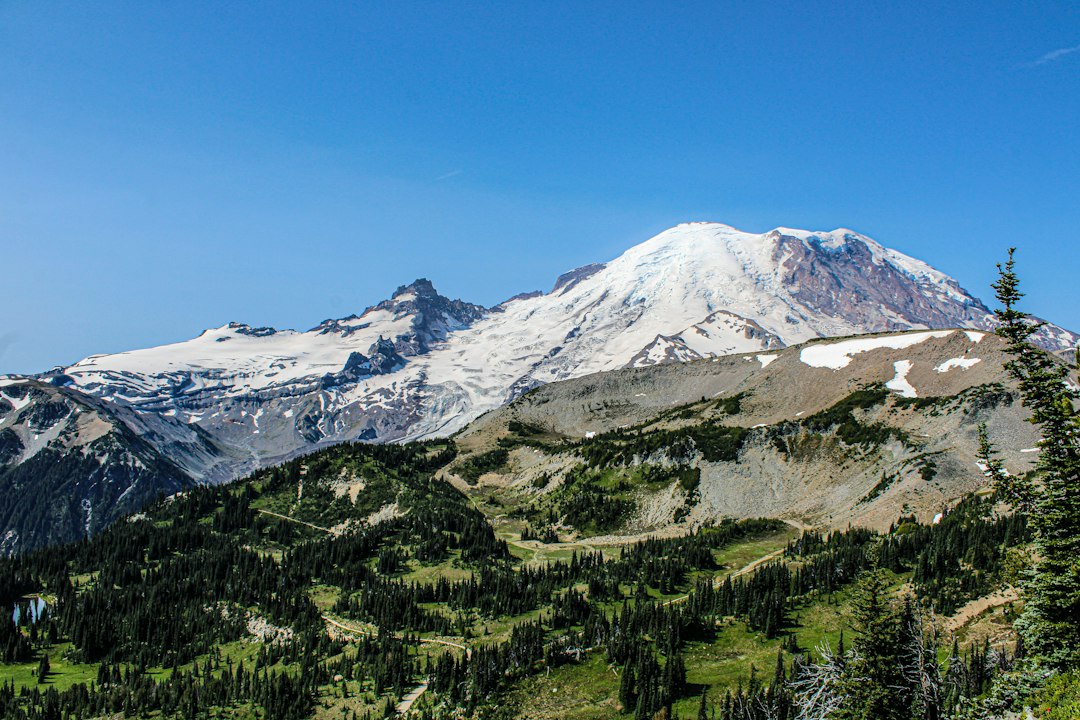
The Mount Fremont Lookout is a 1934 fire lookout at 7,181 feet in the northeast corner of Mount Rainier National Park, the highest lookout in the park. You reach it on a 5.6-mile round-trip hike from the Sunrise Visitor Center with about 1,200 feet of climbing, usually in 2.5 to 4 hours. In a normal year the season runs from early or mid-July, once the snow melts, until Sunrise Road closes in late September or early October.
For the rest of 2026 the trail is closed. The Grand Park 2 Fire shut the Sunrise area on August 7, 2026, and on its October 19 fire update the park said trails north of Sourdough Ridge, "including Mount Fremont Trail," remain closed. The views and cloud odds below come from a terrain model and ten years of modeled weather data that we analyzed for this post.
Mount Fremont Lookout Hike at a Glance
The Mount Fremont Lookout hike is an out-and-back trail of moderate difficulty. It starts at 6,400 feet, so most of the work is the steady climb in thin air over the last mile.
| Detail | Figure | Source |
|---|---|---|
| Distance | 5.6 miles round trip | WTA |
| Elevation gain | About 1,200 ft round trip | WTA |
| Start | Sunrise Visitor Center, about 6,400 ft | NPS |
| Lookout | 7,181 ft, highest in the park | NPS |
| Time | 2.5 to 4 hours | Allow extra time at the top |
| Season | Sunrise Road usually opens late June or early July and closes late September to early October | NPS Sunrise; snow lingers longest near Frozen Lake |
| Permit | None for day hiking | Park entry is $30 per vehicle (NPS fees) |
| Dogs | Not allowed | NPS pets |
| Camping | None at or near the lookout | NPS |
| Water | None on the trail | Fill up at Sunrise |
Is the Mount Fremont Lookout Trail Open?
No. As of late October 2026, the Mount Fremont Lookout trail is closed, and Sunrise Road is closed to cars and pedestrians for the season. The NPS trail conditions page lists "Mt. Fremont Trail CLOSED due to Grand Park 2 Fire until further notice."
Here is how the 2026 season played out:
- July 4: Sunrise Road opened for the summer (WTA).
- August 7: The Grand Park 2 Fire was reported around 12:30 p.m. about three miles north of the Sunrise Visitor Center. The park closed Sunrise and White River the same day and escorted visitors out (NPS, August 9).
- October 19: White River and Sunrise roads closed to cars and pedestrians for the season. Bicycles can still ride the closed roads, and the park's fire page says trails north of Sourdough Ridge, including Mount Fremont, remain closed until further notice.
Before the fire, Sunrise had been open to cars for only about five weeks of the 2026 season. The fire burned north of Sunrise, so when the trail reopens, burned areas may be part of the view north. NPS has not given a reopening date.
What to expect in 2027. The Fryingpan Creek Bridge, which carries traffic toward Sunrise, is being replaced. Construction runs through the 2027 to 2029 seasons (NPS construction page). In a press release, the park said major work begins in spring 2027, completion is expected by late fall 2029, and areas east of the bridge will have a shorter season during construction, with one-lane traffic and delays of up to 30 minutes (Courier-Herald). Plan for a short Sunrise season and check the park page before you go.
The Route: Sourdough Ridge, Frozen Lake, Then the Ridge
The route has three parts. You climb Sourdough Ridge, follow it west to Frozen Lake, then cross the open slope up to the lookout. The trail is easy to follow once the snow is gone.
Sunrise to Sourdough Ridge (about the first half mile). Start at the north side of the Sunrise parking area. The steepest grade of the first half comes right away, a few hundred feet of climbing up to the ridge crest. At this elevation, take it slower than you would at sea level.
Sourdough Ridge to Frozen Lake (to about mile 1.5). The trail now runs west along the ridge, with small ups and downs. Rainier fills the view to the left the whole way. You reach the five-way junction at Frozen Lake around mile 1.5, where the Wonderland, Burroughs Mountain and Fremont trails meet. Frozen Lake is the water source for Sunrise, so stay out of it. Snow lingers here longest, so expect it into July in normal years.
Frozen Lake to the lookout (the last 1.3 miles). Turn right (north) on the Mount Fremont Trail. WTA puts this leg at 1.3 miles and 481 feet of climbing, partly on steps its crews built in 2017. The trail crosses the west side of a rocky ridge with almost no shade, then makes a final rise to the lookout at the ridge's north end.
Because this last stretch faces west, it gets the full afternoon sun. Starting in the morning is cooler, and as the next sections show, it also gives you better odds and better light.
What You Can See From Mount Fremont Lookout
The main view from the lookout is Rainier's north side, 6.9 miles to the southwest. On a very clear day you can also see Mount Baker, Glacier Peak, Mount Stuart and the Olympics. The cabin sits on the north end of the ridge, so Grand Park and the Huckleberry Creek valley spread out below you to the north and northwest.
To check what is in line of sight, we traced each line from the lookout across a public digital elevation model (roughly 30-meter resolution), with Earth curvature and a standard refraction factor. We ran the same check from the Sunrise Visitor Center for comparison. Treat it as a geometric model, not a guarantee: peaks that clear the terrain by a fraction of a degree can be lost to haze or small terrain errors.
| Peak | Distance from lookout | Direction | Visible from lookout? | Visible from Sunrise Visitor Center? |
|---|---|---|---|---|
| Mount Rainier summit | 6.9 mi | Southwest (216°) | Yes, about 11° above eye level | Yes |
| Mount Stuart | 52 mi | Northeast (44°) | Yes | No (Sourdough Ridge blocks it) |
| Glacier Peak | 86 mi | North-northeast (18°) | Yes, barely | No |
| Mount Baker | 127 mi | Due north (357°) | Yes, barely | No |
| Olympic Mountains | ~110 mi | West-northwest (303°) | Yes, right on the skyline | No |
| Mount Adams | 51 mi | South (170°) | No | No |
| Mount St. Helens | 57 mi | South-southwest (206°) | No | No |
| Mount Hood | 108 mi | South (181°) | No | No |
Three things stand out.
The northern views are why you make the climb. Sunrise sits just below Sourdough Ridge, which blocks everything to the north. From the lookout you can see across the North Cascades, and on a clean-air day the view reaches Mount Baker near the Canadian border. Baker and Glacier Peak only just clear the terrain in the model, so any haze or wildfire smoke will hide them first.
The southern volcanoes are hidden. The lookout is not on the ridge's highest point. In the terrain model, a higher bump about 0.6 mile south of the cabin blocks Mount Adams. St. Helens and Hood sit behind Rainier itself and its eastern flank. You see those from the south side of the park, at Paradise and along Skyline, which we cover in the Skyline Trail guide.
Rainier looks huge, and it stays in view. From the lookout the summit sits about 11 degrees above eye level. From Kerry Park in Seattle it sits 2.1 degrees up, so it rises about five times higher in your field of view. The face you see is the north and northeast side: the Winthrop Glacier, the summit dome and Liberty Cap, with the Burroughs Mountain plateaus in front. For the summit geometry from other viewpoints, see our Mount Rainier summit guide.
How Often Is Rainier Clear From the Fremont Lookout?
In ten years of modeled weather data, Rainier was clear for at least three hours in a row on about 70 to 80 percent of days from the second half of July through early August, dropping below half of days by late September. We calculated this from 2016 to 2025 hourly cloud estimates from the Open-Meteo historical weather API. These are model estimates for grid cells several kilometers wide, not observations from the lookout, so read them as rough seasonal odds. We counted the mountain as out when the summit grid cell had 30 percent cloud cover or less and the lookout's own cell was not buried in low cloud.
| Period | 3+ clear hours (7 AM to 7 PM) | At least one clear hour | Lookout itself in cloud at midday |
|---|---|---|---|
| July 1 to 15 | 62% | 77% | 14% |
| July 16 to 31 | 82% | 89% | 4% |
| August 1 to 15 | 71% | 86% | 7% |
| August 16 to 31 | 65% | 79% | 9% |
| September 1 to 15 | 55% | 69% | 9% |
| September 16 to 30 | 47% | 62% | 23% |
"Lookout in cloud" means the lookout's grid cell had more than 80 percent low cloud for at least three of the five hours from 10 AM to 2 PM. On those days you stand inside the cloud and see nothing at all. The share stays under 1 in 10 from mid-July through mid-September, then jumps to almost 1 in 4 in late September as fall systems arrive.
In this data, late July was the best two weeks of the summer. Results vary a lot from year to year: for the window from July 15 to September 15, the share of clear days ranged from 54 percent in 2019 to 81 percent in 2017 and 2020. One summer's luck says little about the next.
The 8 AM sky is a useful guide to the day. Between mid-July and mid-September in the same data, when the summit was clear at 8 AM, it was still clear at 11 AM on 85 percent of days and at 1 PM on 74 percent. When it was hidden at 8 AM, it was clear at 11 AM on only 21 percent of days and at 1 PM on 22 percent, although about half of those days did get at least one clear hour at some point later. Time of day matters less than you might think. Clear hours run 58 to 60 percent from dawn to 11 AM, fall to 50 percent at 2 to 3 PM, then rise to 59 percent by 8 PM.
That makes the decision simple. If the mountain is out when you get to Sunrise, go straight up. If it is hidden, don't count on it clearing by the time you reach the top. Choose a hike where the view matters less, or come back another day. You can check whether the summit is out before you drive with our live Mt. Rainier visibility score. The methodology page explains how the score weighs cloud, haze and humidity. Our Mt. Rainier weather guide covers the patterns behind these numbers.
Morning Light vs. Afternoon Light
Morning gives the best light at the Fremont Lookout. The sun rises in the east-northeast (about 56° in mid-July and 67° in mid-August), behind you as you face the mountain, so it lights the Winthrop Glacier and the northeast face head-on.
By about 2:30 PM in summer, the sun sits right over the summit's bearing of 216°. It is high in the sky, 50 to 60 degrees up, so it won't shine in your eyes. But the face you are looking at is in its own shadow. Photos look flat and hazy, and the glaciers lose their texture. In the evening the sun moves into the northwest and lights the mountain from the side, and alpenglow returns around sunset (about 9 PM in mid-July).
Put the cloud data and the light together and the plan is to start early. A trailhead start by 8 AM puts you at the lookout around 9:30 or 10. Then you have the best light, the cooler half of the day on the west-facing ridge, and the 8 AM sky check working in your favor.
A Short History of the Mount Fremont Fire Lookout
The Mount Fremont Fire Lookout was built in the 1934 season, one of four new lookouts the park built that year. Workers from the Emergency Conservation Work program cut the trails and carried in the materials. By 1935 seven lookouts watched over the park. Four remain today, including Tolmie Peak and Gobblers Knob.
The park's historic structure inventory describes a standard design: the "Standard Lookout House, Type No. 1, For all Parks," drawn by the NPS Western Division's Branch of Plans and Design. It is a two-story timber frame cabin, 14 by 14 feet. Storage was on the ground floor. The upper room held a fire finder, charts, a bed and cooking facilities, with windows on all four sides and a wraparound balcony. Wire-rope guys tie the building to buried concrete anchors, and it needs them. Soon after it was finished, a windstorm tore off the hip roof, and it was repaired right away. Another storm in 2006 damaged both Fremont and Gobblers Knob, and both were repaired (Wikipedia).
Watchers reported smoke and lightning strikes by telephone until aerial spotting took over after World War II. The lookout was added to the National Register of Historic Places in 1991, and NPS says the lookouts are "still used occasionally." Don't count on the cabin being open when you arrive. The view is the reason to come anyway.
Fremont Lookout or Burroughs Mountain?
Choose Fremont if you want a moderate half-day hike with a historic cabin at the end and a view north across the Cascades. Choose Burroughs Mountain if you want to get closer to Rainier's glaciers and have energy for about 9 miles and 2,500 feet of climbing to Third Burroughs at 7,828 feet (WTA).
Both start at Sunrise and split at Frozen Lake, so on the day you can decide based on the snow and the sky. Burroughs is more exposed, and WTA warns that a snowfield often lingers on the approach to First Burroughs into early summer. In early or mid-July, Fremont is usually the simpler choice. Our Mount Rainier hikes guide compares both with every other major trail in the park, and the Sunrise area guide covers the visitor center, parking and the road.
Before You Go
Bring all your water. There is no water past Sunrise, and you can't use Frozen Lake because it is the area's water supply. Modeled early-afternoon temperatures near the lookout are typically around 60°F in July and August, the 50s in September and around 40°F in October, and there is little shade on the final mile. Strong afternoon gusts are uncommon in midsummer and become more frequent into fall.
Watch for wildlife from the top. WTA suggests bringing binoculars to look for mountain goats and black bears in Grand Park, the long meadow northwest of the lookout.
Stay on the trail. The meadows near Sunrise recover very slowly from boot traffic. Dogs are not allowed on any trail here.
Pay the park entry. It is $30 per vehicle or covered by an annual pass. Our entrance fee guide covers the options. Check the national park guide for the latest road and facility status across the park.
Check the mountain before the long drive. Sunrise is a long drive from Seattle on winding mountain roads, and it is a real disappointment to arrive and find the summit in cloud. Check the Mt. Rainier forecast the night before and again in the morning. If the mountain is out at 8 AM, the odds favor you all the way to the lookout.
More Articles
Mt. Rainier Sunrise: Complete Guide to the Park's Highest Viewpoint
Your complete guide to Mt. Rainier Sunrise: road dates, best hikes, wildflowers, and how to time your visit for clear views of the mountain.
Hikes in Mount Rainier National Park: Best Trails by Area
Hikes in Mount Rainier National Park by area, with 2026 closures, snow-free timing and the odds of a clear summit by month and hour.
Skyline Trail Mount Rainier: Loop Guide, Snow and Cloud Odds
Skyline Trail Mount Rainier guide: the 5.5-mile Paradise loop, which way to hike it, when the snow melts and the odds the summit stays clear.