Hikes in Mount Rainier National Park: Best Trails by Area
Hikes in Mount Rainier National Park by area, with 2026 closures, snow-free timing and the odds of a clear summit by month and hour.
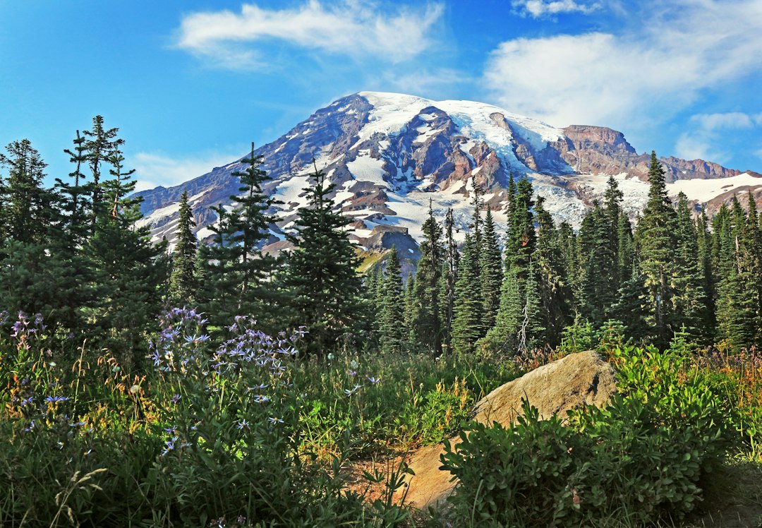
The best hikes in Mount Rainier National Park are the Skyline Trail at Paradise, Mount Fremont Lookout and Burroughs Mountain at Sunrise, the Naches Peak Loop at Chinook Pass, and Comet Falls near Longmire. The park has more than 260 miles of maintained trail, from half-mile forest loops to the 10,080-foot snowfield at Camp Muir.
Picking a trail is only half the job, though. Three other things decide whether a hike works out: which roads are actually open, whether the trail has melted out, and whether the mountain will be out when you reach the viewpoint. This guide covers all three. It includes a cloud dataset built for this post that shows how often the summit is clear in each part of the season, and which hours of the day give you the best odds.
Table of Contents
- What's Open for Hiking in Fall 2026
- Hikes in Mount Rainier National Park at a Glance
- Paradise and Stevens Canyon Hikes
- Longmire and the Nisqually Corridor
- Sunrise, White River and Chinook Pass
- Ohanapecosh, the Northwest Corner and the Wonderland Trail
- How Often the Summit Is Clear on a Hiking Day
- Snow Line: Why the High Point Decides Your Date
- Match the Hike to the Forecast
- Frequently Asked Questions
What's Open for Hiking in Fall 2026
As of late September 2026, Paradise, Longmire, Stevens Canyon and Chinook Pass are open, but you cannot drive to Sunrise, Carbon River or Mowich Lake. That puts several of the park's most famous hikes out of reach this season.
- Sunrise Road is closed to vehicles for the rest of the 2026 season because of the lightning-caused Grand Park 2 Fire, reported on August 7 about three miles north of the Sunrise Visitor Center (InciWeb), and the nearby fires the NPS groups as the Wonderland Complex. Walkers and cyclists may go past the closure, but the trailheads for Burroughs Mountain and Dege Peak are a long way up the road, and the Mount Fremont Trail itself is closed because of the fire, according to the NPS trail conditions page.
- White River Road and campground reopened on September 5. The Grand Park area trails, the Northern Loop and the Wonderland Trail between the Carbon River Suspension Bridge and White River Campground remain closed, according to the NPS alerts page (updated September 24).
- The Fryingpan Creek parking area and Summerland spur trail close on September 28, 2026 and stay closed until the Fryingpan Creek bridge project is finished, so Summerland is effectively off the list as a day hike. The Wonderland Trail stays open from White River Campground, but that makes it a much longer day.
- Carbon River and Mowich Lake are unreachable. The Fairfax Bridge on SR 165 is closed to vehicles, bikes and pedestrians, which rules out Tolmie Peak, Spray Park and the Carbon River rainforest.
- Grove of the Patriarchs stays closed. Its suspension bridge was damaged in the November 2021 floods, and the NPS now lists 2028 for the start of replacement work.
The rest of the rules have not changed. There is no timed-entry reservation in 2026, entry costs $30 per vehicle for seven days, pets and bicycles are banned on park trails (the Pacific Crest Trail is the one exception for leashed dogs), and the park recommends day-hiking groups of no more than 12 people. For more construction and closure detail, see our running Mt. Rainier news roundup. Check the official road status page on the morning you drive.
Hikes in Mount Rainier National Park at a Glance
This table lists the most popular day hikes in Mount Rainier National Park with round-trip distance, elevation gain and the trail's high point. Distances and gains come from Washington Trails Association hike pages and the NPS day hiking page. Sources round slightly differently, so treat a 100-foot difference as noise.
| Hike | Area | Round trip | Gain | High point | Rainier view | Fall 2026 |
|---|---|---|---|---|---|---|
| Nisqually Vista | Paradise | 1.2 mi loop | ~200 ft | ~5,450 ft | Glacier close-up | Open |
| Myrtle Falls | Paradise | 1.0 mi | ~100 ft | ~5,500 ft | Falls framed by summit | Open |
| Skyline Trail | Paradise | 5.5 mi loop | 1,450 ft | 6,800 ft | Face to face | Open |
| Camp Muir | Paradise | 8.0 mi | 4,640 ft | 10,080 ft | On the mountain | Open (snowfield) |
| Pinnacle Saddle | Stevens Canyon | 2.5 mi | 1,000 ft | 5,920 ft | Looking back north | Open |
| Bench and Snow Lakes | Stevens Canyon | 2.5 mi | 610 ft | 4,725 ft | From Bench Lake | Open |
| Carter and Madcap Falls | Longmire | 2.8 mi | 660 ft | 3,650 ft | Mostly forest | Open |
| Rampart Ridge | Longmire | 4.6 mi loop | ~1,340 ft | ~4,000 ft | One big viewpoint | Open |
| Comet Falls | Longmire | 3.8 mi | 1,250 ft | 4,875 ft | None at the falls | Open |
| Naches Peak Loop | Chinook Pass | 3.2 to 3.5 mi loop | ~600 ft | ~5,850 ft | Classic east-side view | Open |
| Glacier Basin | White River | 6.5 mi | 1,600 ft | 5,900 ft | Up the Inter Glacier | Not listed as closed |
| Mount Fremont Lookout | Sunrise | 5.6 mi | 1,200 ft | 7,200 ft | Huge north face | Trail closed (fire) |
| Burroughs Mountain | Sunrise | 9.0 mi | 2,500 ft | 7,828 ft | Winthrop Glacier close-up | No car access |
| Dege Peak | Sunrise | 4.0 mi | 600 ft | 7,006 ft | 360-degree volcano view | No car access |
| Summerland | White River | ~9 mi | ~2,000 ft | ~5,900 ft | Rainier and Little Tahoma | Trailhead closed from Sep 28 |
| Tolmie Peak Lookout | Mowich | 7.5 mi | 1,100 ft | 5,900 ft | Lookout over Eunice Lake | Unreachable |
Paradise and Stevens Canyon Hikes
Paradise has the park's highest concentration of hikes, and in the 2026 season it is the largest meadow area you can still drive to. At 5,400 feet it stays open year-round, so it will still be your trailhead after the other corridors close for winter.
Skyline Trail is the signature loop. It climbs 5.5 miles through subalpine meadow to Panorama Point at 6,800 feet, where the Nisqually Glacier fills the view and Mount Adams, Mount St. Helens and on a clear day Mount Hood line up to the south. Allow three to five hours. A steep snowfield east of Panorama Point can linger well into summer; the WTA Skyline page notes that some hikers take the High Skyline route instead.
Nisqually Vista and Myrtle Falls are the easy wins. Both start at the visitor center, both come in around a mile, and both put the mountain directly in front of you. Myrtle Falls is a classic photo stop because the falls sit in the foreground with the summit behind. Our Paradise visitor guide covers parking, lodging and the wildflower calendar in detail.
Camp Muir is the highest point you can reach without a climbing permit. Above the first 2 miles of meadow trail, the route crosses the Muir Snowfield, and WTA notes it is snow-covered along its entire length until August. In fog the snowfield turns featureless, and people who drift off the route end up on the crevassed Nisqually Glacier. The WTA Camp Muir page recommends a GPS track or compass bearings. Do not start this one without a clear forecast for the whole day.
Pinnacle Saddle starts at Reflection Lakes on Stevens Canyon Road and climbs 1,000 feet in 1.25 miles to a notch in the Tatoosh Range. It's the best short climb for a view back at the mountain across Paradise. At dawn you can pair it with the lakes themselves. See our guide to Reflection Lakes for the calm-water conditions you need for the mirror shot.
Bench and Snow Lakes, a little further along Stevens Canyon, is a 2.5-mile round trip that the WTA recommends for getting away from the crowds. Snow Lake sits in a cirque under Unicorn Peak. The mountain view is partial from a rock outcrop and fuller from Bench Lake's shore, and the lakes still make a good walk on the days when clouds hide the summit.
Longmire and the Nisqually Corridor
Longmire's hikes sit between 2,700 and 4,900 feet, in old-growth forest and along river gorges. That makes them the park's best choice when the summit is in cloud. They also melt out weeks before Paradise.
Comet Falls is the standout. It's a 3.8-mile round trip with 1,250 feet of gain to a waterfall that drops 301 feet in a single plunge, with the 124-foot Bloucher Falls on the way. Van Trump Park lies above it, a steep continuation into meadows with a close view of the mountain for hikers with more energy. The WTA Comet Falls page describes a crib ladder at 1.2 miles and a footlog crossing, so it is not a sneaker stroll.
Carter and Madcap Falls follows a piece of the Wonderland Trail up the Paradise River to a 53-foot waterfall, 2.8 miles round trip. Rampart Ridge is a 4.6-mile loop from Longmire that climbs through forest to a single, dramatic viewpoint facing the mountain, then drops back along the Wonderland Trail. The short Trail of the Shadows loop (0.7 miles) around the Longmire meadow is one of the easiest walks in the park.
If you are driving this corridor anyway, Narada Falls is a five-minute stop on the way up to Paradise and works in any weather.
Sunrise, White River and Chinook Pass
In a normal year Sunrise, at 6,400 feet, is the park's highest road-accessible trailhead and the start of its best view hikes. For the rest of 2026, the only way in is on foot or by bike, up the closed road or by trail from White River Campground.
Mount Fremont Lookout (5.6 miles, 1,200 feet) ends at a two-story fire lookout built in 1934, with the mountain's north face on one side and Grand Park below. Burroughs Mountain (9 miles, 2,500 feet) crosses tundra to Third Burroughs at 7,828 feet. It puts you face to face with the Winthrop Glacier, and the WTA Burroughs page warns of a steep snowfield on the approach to First Burroughs into early summer. Dege Peak (4 miles, 600 feet) is the family option, with a view that stretches to Mount Baker and Glacier Peak. The Mount Fremont Trail is closed for the fire, and the NPS lists the Burroughs trails as open only via the White River Campground trailheads, which turns Burroughs into a much bigger day. Plan these for 2027. Our Sunrise area guide explains the usual road season and how Sunrise compares with Paradise.
Glacier Basin starts at the far end of White River Campground and climbs 3.25 miles up the valley to the basin below the Inter Glacier. It wasn't on the NPS closure list as of September 24, and with White River reopened it is the most promising northeast-side hike left this fall. Confirm its status before you go.
Naches Peak Loop at Chinook Pass sits just outside the Sunrise closure on SR 410. It's a loop of roughly 3.2 to 3.5 miles (WTA and the NPS measure it slightly differently) with about 600 feet of gain. Walk it clockwise and the mountain stays in front of you on the western half, with Upper Tipsoo Lake in the foreground. Half the loop is Pacific Crest Trail on national forest land and half is in the park, so you can't complete the loop with a dog: leashed dogs are allowed only on the PCT half. See our Tipsoo Lake guide for the reflection timing.
Ohanapecosh, the Northwest Corner and the Wonderland Trail
The southeast and northwest corners of the park are old-growth forest country. They don't give you mountain views, but they're dependable on cloudy days, and right now only the southeast corner can be reached.
At Ohanapecosh, Silver Falls drops 75 feet into a green gorge on the Ohanapecosh River. In 2026 the usual trailhead in Ohanapecosh Campground is closed for construction, so start from the Grove of the Patriarchs parking lot and follow the Eastside Trail, about a 1-mile round trip according to the NPS day hiking page. The trail can't be walked as a loop this year. The Grove of the Patriarchs itself, with its thousand-year-old cedars and Douglas firs, is still closed behind the damaged bridge.
The northwest corner holds two of the park's best-loved hikes: Tolmie Peak Lookout above Eunice Lake and the flower meadows of Spray Park, both reached from Mowich Lake. Until the Fairfax Bridge problem is solved, neither can be reached from SR 165.
The Wonderland Trail circles the whole mountain in about 93 miles with roughly 27,000 feet of climbing, according to the NPS Wonderland Trail page. It's a backpacking trip, not a day hike, and it needs a wilderness permit. About two-thirds of permits can be reserved, and applicants who win an early-access lottery, which opens in February, get booking windows between March and April before general reservations open on April 25. The remaining third are issued first come, first served at the wilderness information centers. For day hikers, the useful point is that many hikes in this list, including Carter Falls, Rampart Ridge and Summerland, follow sections of it.
How Often the Summit Is Clear on a Hiking Day
In weather-model data for 2016 to 2025, the summit grid cell had a clear three-hour window on 83% of days in late July, falling to 29% in the second half of October. We built these numbers for this post from ten years (2016 to 2025) of hourly cloud cover at the summit grid point, using the Open-Meteo historical weather API with its default best-match model blend. Each half-month row covers 150 to 160 days, so these are modeled averages from ten seasons, not observations from the ground.
A "clear window" means at least three consecutive hours between 7 AM and 7 PM with 30% cloud cover or less. A "glimpse" means at least one such hour.
| Period | Clear 3-hour window | At least a glimpse |
|---|---|---|
| June 1 to 15 | 33% | 50% |
| June 16 to 30 | 53% | 70% |
| July 1 to 15 | 64% | 78% |
| July 16 to 31 | 83% | 89% |
| August 1 to 15 | 73% | 86% |
| August 16 to 31 | 65% | 79% |
| September 1 to 15 | 55% | 70% |
| September 16 to 30 | 47% | 62% |
| October 1 to 15 | 48% | 56% |
| October 16 to 31 | 29% | 44% |
| June (whole month) | 43% | 60% |
| July | 74% | 84% |
| August | 69% | 82% |
| September | 51% | 66% |
| October | 38% | 50% |
Three things stand out.
Late July is the peak, not August. The clearest two weeks are July 16 to 31, which also line up with snow melting off the meadow trails. By late August the odds are slipping, and wildfire smoke, which a cloud model doesn't record, becomes a factor.
Good seasons vary a lot. Across July and August, the clear-window rate ranged from 55% (2019) and 56% (2016) to 90% (2017). A given summer can be a lot better or worse than the average.
Paradise and Sunrise barely differ on cloud. Run the same numbers at the Paradise and Sunrise grid points and July comes out at 76% and 75%, and September at 54% and 50%. Sunrise gets less snow and rain than Paradise, but in this model data the two areas show nearly the same cloud pattern. Choose between them on trail, snow and access, not on which one is more likely to be clear.
These figures describe modeled cloud cover over a grid cell several kilometers across, not a line of sight from a particular trail, and they ignore wildfire smoke, so treat them as a ranking of when to plan, not a promise for your date. On the day itself, the live score on our Mount Rainier visibility forecast is a better guide, and our weighted atmospheric model explains how that score is built.
The Clearest Hours: Be at the Viewpoint Before 11 AM
In July through September, the summit is clear in 56% of hours at 9 and 10 AM but only 47% at 2 and 3 PM, after which it recovers to 55% by 8 PM. The dip fits the familiar pattern of afternoon cloud building over a big mountain, and it matters for timing the hikes.
- Time the big views for the morning. On Skyline, reaching Panorama Point around 10 AM means starting from the lot at about 8:30, which also beats the summer parking crunch.
- An evening walk makes a good second chance. On a day that clouds over at lunch, the short Paradise loops or a return to Reflection Lakes before sunset often get the view back.
- Put the mid-afternoon into forest. Comet Falls, Carter Falls and Silver Falls need no view, so they fill the cloudiest hours well.
Snow Line: Why the High Point Decides Your Date
A trail's highest point predicts when it melts out better than its trailhead elevation does. A hike that starts in the forest can still end on a snowfield. Rainier's meadows get enormous snowfall, and the timing moves with the elevation band.
| High point | Typical snow-free window | Examples |
|---|---|---|
| Below 4,000 ft | Late spring through fall | Trail of the Shadows, Carter Falls, Silver Falls |
| 4,000 to 5,000 ft | Late June or early July onward | Comet Falls, Bench and Snow Lakes |
| 5,000 to 6,000 ft | Mid-July to mid-October | Naches Peak Loop, Pinnacle Saddle, Glacier Basin |
| 6,000 to 7,000 ft | Late July to early October | Skyline Trail upper section |
| Above 7,000 ft | Snow patches most of the season | Burroughs Mountain, Camp Muir (never snow-free) |
Treat these as rough guides built from the trails' elevations and the NPS and WTA trail notes; for comparison, the NPS says the Wonderland Trail is typically mostly snow-free from mid-July to October. A big snow year can push melt-out back by weeks. The early-season trap is a warm, clear forecast in the city while a south-facing meadow at 6,500 feet is still buried. Check the NPS trail conditions page and recent WTA trip reports before any hike with a high point above 5,500 feet.
The overlap of the two tables is the core planning insight. The clearest weeks (late July) arrive just as the upper trails melt out, so the second half of July is the best time for the high view hikes. The meadows are at their greenest then too. In September the snow is gone and the crowds thin, but a clear window is closer to a coin flip. Freezing levels also start dropping, so read the recreational forecast before any hike that goes above 6,500 feet.
Match the Hike to the Forecast
Choose the view hike on the morning you go, based on the forecast, not weeks in advance. Plan a route for each type of day and pick one before you leave the house:
| Morning forecast | What it means | Best hikes |
|---|---|---|
| Visibility score 70+, clear all day | The mountain is out | Skyline, Pinnacle Saddle, Naches Peak Loop, Camp Muir |
| Clear morning, afternoon clouds building | Short window | Skyline or Nisqually Vista early, then Comet Falls |
| Low cloud in the valleys, clear aloft | You may climb out of it | Paradise trails (5,400 ft trailhead), not Longmire |
| Summit in cloud all day | No view anywhere | Comet Falls, Carter Falls, Silver Falls, Rampart Ridge |
| Rain or thunderstorms at elevation | Exposure risk | Trail of the Shadows, or save the drive |
The live score on our Mount Rainier visibility page updates every 15 minutes, with 70 or higher meaning good viewing and 90 or higher excellent. Check it before you commit to the drive from Seattle, which our distance guide puts at about two and a half hours to Paradise once you add the climb from the gate. Cell coverage inside the park is patchy, so load the forecast before you leave town. The Mt. Rainier weather guide covers what each month is like at each elevation.
Frequently Asked Questions
What is the most popular hike in Mount Rainier National Park?
The Skyline Trail at Paradise is the park's signature hike and one of its busiest. The 5.5-mile loop climbs to Panorama Point at 6,800 feet with close views of the Nisqually Glacier and wildflower meadows in late July and August. For something shorter with the same scenery, walk to Myrtle Falls (1 mile round trip).
What is the easiest hike at Mount Rainier?
Nisqually Vista at Paradise is the easiest hike with a big view. It's a 1.2-mile loop with about 200 feet of gain that ends facing the Nisqually Glacier. Trail of the Shadows at Longmire is flatter but stays in forest.
Do you need a permit to hike at Mount Rainier?
You do not need a permit for day hikes, only the entrance pass ($30 per vehicle for seven days, or an America the Beautiful pass). Overnight trips need a wilderness permit, and a climbing permit is required above 10,000 feet or on glaciers, which is why Camp Muir is the limit for hikers.
Are dogs allowed on Mount Rainier trails?
Mostly no. Pets are banned on every park trail except the Pacific Crest Trail along the eastern border, where dogs on a leash of six feet or less are allowed. Leashed dogs may also use parking lots, campgrounds and paved roads open to vehicles, per the NPS pet rules.
Build Your Day Around One Clear Morning
This fall, the most reliable plan is Paradise at first light. Hike Skyline or Pinnacle Saddle if the summit is out, walk Comet Falls if it isn't, and push the Sunrise hikes to next summer. Next July, aim for the second half of the month and keep two plans ready, a view hike and a forest hike, then let the morning's visibility score choose between them.
More Articles
Paradise Mt Rainier: The Complete Visitor Guide for Every Season
Plan your trip to Paradise at Mt Rainier with trail details, parking tips, wildflower timing, and visibility forecasts.
Mt. Rainier Sunrise: Complete Guide to the Park's Highest Viewpoint
Your complete guide to Mt. Rainier Sunrise: road dates, best hikes, wildflowers, and how to time your visit for clear views of the mountain.
Tipsoo Lake Mt. Rainier: Reflection Guide, Trail & Best Time
Tipsoo Lake at Mt. Rainier delivers the park's best east-side reflection. Learn the road window, where the mirror really is, and when to go.