Mount Rainier Summit: Climbing Routes, Odds and the Crater
Mount Rainier summit guide: the three summit points, why Paradise never sees the top, NPS success rates since 1950 and the clearest summit-morning months.

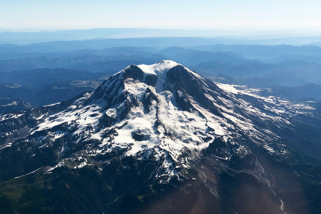
The Mount Rainier summit is Columbia Crest, a dome of snow and ice on the rim of the volcano's summit crater, 14,410 feet above sea level by the National Park Service's official figure. It is not a hike. Every route crosses glaciers, the standard route gains about 9,000 feet, and every climber needs a climbing registration. Roughly 10,000 people try each year, and in the last decade the park counted summits (2009 to 2018), about half of them made it.
This guide includes three pieces of original analysis: a terrain model of which of Rainier's three summit points you see from Paradise, Sunrise and Seattle (from Paradise, it is not Columbia Crest); National Park Service success rates since 1950 compared with modeled summer weather; and 30 years of modeled summit-morning cloud plus four years of modeled summit-altitude wind, by month.
Mount Rainier Summit Facts
The Mount Rainier summit area is a broad, ice-filled double crater with three named high points, all above 14,000 feet.
| Detail | Figure | Source |
|---|---|---|
| Official elevation | 14,410 ft (4,392 m), Columbia Crest, from the 1956 USGS survey; GPS surveys in 1988 and 1999 gave 14,411 ft, a figure many sources use | NPS climbing page, height guide |
| Measured high point, 2025 | 14,406.3 ft, a rock point on the southwest crater rim | Gilbertson survey |
| Columbia Crest, 2025 | 14,394.6 ft (about 23 ft lower than in 1999) | Same survey |
| Other summit points | Point Success (south) and Liberty Cap (northwest), both above 14,000 ft; Liberty Cap measured 14,094.9 ft in 2025 | 1936 UW geology report, Gilbertson survey |
| Climbers per year | About 9,000 to 11,000 registered | NPS annual statistics |
| Success rate | 50% from 2009 to 2018 (last year summits were counted) | NPS, calculated below |
| Elevation gain | About 9,000 ft over 8 to 9 miles on the standard route | NPS route brief |
| Climbing registration | $82 per person, plus $12 per person per night to camp | NPS climbing page |
| Main season | Mid-May to late September | NPS route brief |
The 2024 and 2025 surveys mean the "summit" most climbers walk to is no longer the highest ground on the mountain. The Mt. Rainier height guide covers that story in detail. For a climber, little changes: the park still treats Columbia Crest as the summit, and the measured high point sits about 436 feet away on the same rim.
What Is at the Summit of Mount Rainier?
The top of Mount Rainier is a pair of overlapping volcanic craters filled with ice, ringed by a rocky rim that steams. Columbia Crest is the highest snow dome on that rim, on its northwest side.
The park's own description of the climb gives the best picture of it. The standard route reaches the crater at its southern edge near an outcrop called Guide Rock, at about 14,150 feet. Climbers usually unrope there and walk across the crater to Columbia Crest. On the way they pass Register Rock, a snow-free patch with active fumaroles where the summit register sits in a metal box. The round trip from Guide Rock to Columbia Crest takes most parties about 45 minutes, and the NPS route brief suggests about an hour in the crater in total.
Under the ice, volcanic heat has melted caves into the crater. Climbers often enter the crater over a snow bridge covering one of them, and the NPS warns that thin snow bridges near the rim have given way under several climbers, injuring them.
Which Summit Are You Looking At From Below?
From Paradise, the highest point you see on Mount Rainier is Point Success, not Columbia Crest. The true summit is hidden behind the mountain's southern shoulder, and in our terrain model it is also hidden from Reflection Lakes.
A 1936 University of Washington geology report on the park noted that the summit area is "so broad that from no point about the base can one see the actual top of the cone," and that Point Success is judged the highest point from Longmire or Paradise. We checked that against modern terrain data. Using a public elevation model (Mapzen Terrarium tiles built from USGS data), we located the three summit points, traced a line of sight from each viewpoint, and allowed for Earth's curvature and normal atmospheric refraction. These are model results for the exact coordinates used; a few steps left or right, or a few feet of snow, can change a marginal case.
| Viewpoint | Distance to Columbia Crest | Highest point on the skyline | Can you see Columbia Crest? |
|---|---|---|---|
| Paradise visitor center | 4.8 mi | Point Success, 20.5° above level | No. Hidden by about half a degree of ridge, roughly 200 ft of mountain |
| Reflection Lakes | 6.0 mi | Point Success | No |
| Camp Muir | 1.8 mi | The mountain's own upper slopes, a false summit | No. None of the three summit points are in view |
| Sunrise visitor center | 7.0 mi | The summit dome's eastern edge, with Liberty Cap in view | Too close to call. It sits within a few yards of the skyline |
| Tipsoo Lake | 11.5 mi | Columbia Crest | Yes, just |
| Kerry Park, Seattle | 60.6 mi | Columbia Crest, 2.1° above level | Yes, but Liberty Cap looks almost exactly as high |
| Yakima | 61.9 mi | Columbia Crest and the southwest rim, tied | Yes |
Three things fall out of this.
Paradise looks at the wrong peak. Point Success sits about 0.4 miles closer to Paradise than Columbia Crest. That nearness makes it rise about one degree higher in your view, so the rounded top you photograph from the Paradise visitor area and Reflection Lakes is Point Success. Columbia Crest is behind it.
Climbers at Camp Muir cannot see the summit at all. In the model, the mountain's own upper slopes hide all three summit points, so the top you see from high camp is a false one.
From Seattle, the summit is a flat-topped dome. At 60 miles, Columbia Crest, the southwest rim and Liberty Cap all sit within about a hundredth of a degree of each other. That is why Rainier looks like a broad, flat crown from Kerry Park rather than a point.
None of this matters if the top is in cloud, which is common. The live Mt. Rainier visibility forecast tracks whether the summit is showing right now, using a weighted atmospheric model of cloud layers, haze and humidity. The Rainier webcams at Paradise will show you Point Success when it is out.
How Many Climbers Reach the Mount Rainier Summit?
About half of the climbers who attempt Mount Rainier reach the summit. National Park Service records show 50.1% for the ten years from 2009 to 2018, the last year the park recorded summits.
The NPS annual climbing statistics go back to 1950. Grouped by decade, they show a slow slide over the same decades in which the number of climbers grew. The best single year was 1967 (75%) and the worst 1954 (42%).
| Period | Success rate | Notes |
|---|---|---|
| 1950s | 61% | Under 800 climbers a year |
| 1960s | 66% | |
| 1970s | 57% | Attempts pass 6,000 a year |
| 1980s | 53% | |
| 1990s | 56% | No data for 1990; 1999 was the decade's best year at 67% |
| 2000 to 2008 | 52% | 2000 had the most attempts on record, 13,114 |
| 2009 to 2018 | 50% | 2010 was the period's lowest year at 46% |
After 2018, the park stopped recording how many climbers succeeded. It still counts attempts: 10,735 in 2019, 2,752 in pandemic-hit 2020, 9,138 in 2021 and 9,530 in 2022. So a recent-year success rate cannot be taken from the park's public table.
The climbing rangers' 2016 mountaineering report gives a slightly different measure, the share reaching "the actual summit": 46% to 58% a year between 2010 and 2016. Route by route, the park's route briefs put average success at 51% on the Disappointment Cleaver, 54% on the Emmons-Winthrop and 52% on the Kautz.
Why do half of climbers turn around? The Disappointment Cleaver route brief is blunt: the most common reason is fatigue, "almost always due to inadequate training." It calls bad weather "another major factor."
Does a Good-Weather Summer Raise Summit Success?
In this comparison, a clearer summer did not show a clear link to a higher Mount Rainier summit success rate. Across 28 seasons from 1991 to 2018 (1990 has no NPS data), the clearest summers averaged success rates only one or two points above the cloudiest, and the relationship was not statistically significant.
For each climbing season (May 15 to September 15) we counted the share of mornings when the summit area was clear of mid-level cloud from 5 to 9 AM, with almost no precipitation from midnight to 10 AM. The weather data is ERA5 reanalysis, a modeled reconstruction of past weather on a grid of roughly 15 miles, served through Open-Meteo. It describes the grid cell that contains the summit, not observations in the crater. Then we compared that share with the NPS success rate for the same year.
- Correlation: weak and uncertain. The correlation coefficient was about 0.1 using mid-level cloud and 0.34 using total cloud, which also counts low cloud that often sits below climbers. With only 28 seasons, neither result is statistically significant, so a modest real effect cannot be ruled out.
- Clearest third vs cloudiest third: the nine clearest summers averaged about 53% success, the nine cloudiest about 52%.
- The clearest summer in the record, 2017, had clear summit mornings about 77% of the time. Its success rate was 48%, below the long-run average.
- The cloudiest, 2013, had 57% clear mornings and a 47% success rate.
A season-wide average can hide a lot. Climbers choose their days, so a cloudy summer may mostly shift when people climb rather than whether they get up, and a single storm on a busy weekend affects thousands of climbers at once. The park's 2016 mountaineering report says weather is the factor with the greatest effect on climbing numbers and success rates, while the route brief names fatigue as the most common reason a party turns back. This seasonal comparison cannot separate those effects; it only shows that summer-average cloud alone predicts little about the yearly success rate.
The practical lesson: train well, and use the forecast to choose your day.
Best Time to Climb Mount Rainier: Summit Mornings by Month
July is the best month for a Mount Rainier summit morning in 30 years of modeled weather. The summit area was clear at dawn on 78% of July days in the model, and August was close behind at 74%. May and early June are much cloudier than the busy early season suggests.
The table below uses the same ERA5 data for 1996 to 2025. "Clear summit morning" means mid-level cloud at or below 30% for every hour from 5 to 9 AM, when parties on the standard route are typically high on the mountain, and almost no precipitation from midnight to 10 AM. The wind and temperature columns come from four seasons (2022 to 2025) of hourly forecast-model data through Open-Meteo at the 600 hPa pressure level, roughly 13,800 to 14,400 feet, close to summit height. Both are model estimates for a grid point, not measurements on the summit.
| Month | Clear summit morning (1996 to 2025) | Median wind, 5 to 9 AM | Mornings with average wind over 30 mph | Median 6 AM temperature |
|---|---|---|---|---|
| May | 40% | 25 mph | 39% | 14°F |
| June | 53% | 19 mph | 24% | 21°F |
| July | 78% | 21 mph | 24% | 30°F |
| August | 74% | 20 mph | 23% | 29°F |
| September | 62% | 21 mph | 27% | 26°F |
| October | 43% | 32 mph | 55% | 22°F |
Split by half-month, the best stretch in the model is July 16 to 31, with clear summit mornings on 82% of days.
Two patterns stand out.
Clear early mornings close in more often in spring. In the model, about 42% of clear May mornings had mid-level cloud above 30% at some point between 1 and 3 PM, against about 14% in July. That is one more reason for early starts and an early turnaround. The NPS route brief also warns that "cloud caps form on the summit quickly and often without warning," and several parties have been trapped near the top after becoming disoriented in a storm.
Summer at 14,000 feet is still winter. In the model, a typical July dawn near summit height is just below freezing with a wind around 20 mph, and about one July or August morning in four averages over 30 mph. The NPS route brief puts average summer wind chill on the climb at -5°F to 10°F.
The guide services' calendar lines up with the data. RMI charges its highest prices from June 10 to August 20 and notes that early season brings deeper snow and colder nights, late season more open crevasses, and that summit odds are lower outside midsummer. September brings a little more cloud and quieter camps, but the route gets icier and more crevassed as the summer snow melts away.
For general mountain conditions before a trip, the NWS Mt. Rainier recreational forecast gives freezing levels and summit winds, and the Mt. Rainier weather guide covers how conditions stack by elevation.
Climbing Routes to the Mount Rainier Summit
Many routes reach the summit of Mount Rainier, but about 72% of climbers use one of them: the Disappointment Cleaver.
From 2011 to 2016, the park recorded route use as follows (2016 mountaineering report):
| Route | Share of climbers, 2011 to 2016 | Start | High camp | Character |
|---|---|---|---|---|
| Disappointment Cleaver | 72% | Paradise | Camp Muir, 10,080 ft | Guided and marked, crowded on good weekends |
| Emmons-Winthrop | 15% | White River | Camp Schurman, about 9,500 ft | The main northeast-side route, up the Emmons Glacier |
| Kautz Glacier | 4% | Paradise | Camp Hazard or the Rock Step; strong one-night teams camp no lower than the Upper Castle | Technical ice pitches in the Kautz ice chute near 12,000 ft |
| Ingraham Direct | 2% | Paradise | Camp Muir | The park says it now becomes too crevassed to climb safely by mid-May |
| Liberty Ridge | 1% | White River or Carbon River | Thumb Rock | Remote, committing north-side ridge |
The Summit Day on the Disappointment Cleaver
The standard route is about 9,000 feet of gain over 8 to 9 miles from Paradise, by the NPS figures. Day one climbs the Muir Snowfield to Camp Muir. The summit push starts in the dark. Here is the sequence, following the park's route brief:
- Cathedral Gap, 10,800 ft. A rising traverse across the Cowlitz Glacier, then a rocky notch prone to rockfall.
- Ingraham Flats, 11,200 ft. A camp with room for 36 people and a short rest stop for most parties.
- The Icebox and the Bowling Alley, around 12,000 ft. Ice cliffs above and rockfall from the cleaver. The NPS asks for under ten minutes of exposure and no stops. The Icebox is where eleven people died in a 1981 serac collapse, which the park calls the worst mountaineering accident in North American history.
- The Cleaver, to 12,300 ft. A steep rib of loose rock and snow, the crux for many.
- The decision point. The top of the Cleaver is where guides and rangers expect teams to decide. The park's rule of thumb: the rest of the climb will take at least as long as Camp Muir to here took.
- To the crater, about 14,150 ft. Fully glaciated, crevassed and without landmarks, ending at Guide Rock.
- Columbia Crest. A walk across the crater, past Register Rock.
The descent takes about two thirds of the ascent time, and the NPS notes that most accidents happen on the way down. Rockfall is not only an afternoon problem: in July 2026, rockfall at about 11,600 feet on this route struck six climbers, killing one and injuring three at about 3:30 AM.
Permits, Fees and Guided Climbs
Climbing to the Mount Rainier summit costs $82 per person in park registration, plus $12 per person per night for a wilderness camping permit and the $30 vehicle entrance fee. RMI's 2027 guided programs run about $2,600 to $4,600.
The rules come from federal regulation 36 CFR 7.5, and the NPS climbing page (updated July 8, 2026) sets out how they work:
- Who needs a permit: anyone on a glacier or above the normal high camps, at about 10,000 feet.
- Age: 18, or a guardian's permission.
- Solo climbing: banned without special authorization. About 200 people apply each year and fewer than half are approved.
- Summer (May 22 to September 30): pay the $82 online at Pay.gov first, then register in person at a wilderness information station, up to 24 hours before the climb. The park holds about half of each camp's capacity for walk-ups. The rest is reservable.
- Winter (September 15 to May 21): pay online, then fill in a self-registration card at the kiosk by the Paradise Old Station. Few people climb in winter.
Guided Climbs
Three companies hold the park's guided-climbing concession contracts (NPS): Rainier Mountaineering (RMI), International Mountain Guides and Alpine Ascents International. RMI's published 2027 prices give a sense of the market:
| RMI program (2027) | Peak season, June 10 to August 20 | Early or late season |
|---|---|---|
| Four Day Climb (training day plus summit climb) | $2,995 | $2,595 |
| Five Day Climb | $3,595 | $3,095 |
| Five Day Emmons or Kautz Climb | $3,195 | Not listed |
| Four Day Climb Select (smaller rope teams) | $4,595 | Not listed |
A guide does not guarantee the summit. Guides turn around for weather, slow clients and route conditions like everyone else. A late-season discount buys a date with more open crevasses and, in the modeled data above, more September cloud than July or August.
Frequently Asked Questions
Can you hike to the summit of Mount Rainier?
No. Every route to the Mount Rainier summit crosses glaciers and needs ropes, crampons, an ice axe and crevasse rescue skills, plus a climbing registration. The highest point most hikers reach is Camp Muir at 10,080 feet, a long, steep snowfield day hike from Paradise.
How long does it take to climb Mount Rainier?
Most climbers take two to three days on the Disappointment Cleaver route: one day to Camp Muir, then a summit day that starts around midnight and ends back at Muir or Paradise. Guided programs run four or five days including a training day.
What is the highest point on Mount Rainier?
Officially it is Columbia Crest at 14,410 feet, the National Park Service figure; you will also see 14,411 feet, from later GPS surveys. Surveys in 2024 and 2025 found a rock point on the southwest crater rim is now about 12 feet higher than the melting Columbia Crest. The park has not changed its listed figure.
Can you see the summit of Mount Rainier from Seattle?
Yes, on clear days. In our terrain model, from Kerry Park the summit sits about 2.1 degrees above level, 60 miles away, and Columbia Crest itself is in view. The Seattle viewing guide covers the best spots, and the live forecast shows whether the mountain is out today.
Before You Go
If you are planning a climb, train for the hours, not the altitude, and consider a window in July or early August. In 30 years of modeled weather, that is when summit mornings were most often clear. Hold two or three possible summit days, pick the clearest using the recreational forecast, and treat the top of the Cleaver as a real turnaround point.
If you are not climbing, the summit is still something to plan for. From Paradise you will be looking at Point Success. From Tipsoo Lake, Seattle or Yakima, the terrain model shows Columbia Crest itself. The Mount Rainier National Park guide covers where to stand, and the Mt. Rainier visibility forecast tells you whether the top is clear before you make the drive.
More Articles
Mt. Rainier Height: How Tall Is Washington's Highest Peak?
Mt. Rainier height is 14,411 feet (4,392 m), making it the tallest mountain in Washington and the most topographically prominent peak in the contiguous US.
Mt. Rainier Weather: Complete Guide to Conditions and Visibility
Plan your visit with our complete Mt. Rainier weather guide covering monthly conditions, precipitation, snowfall records, and how weather affects mountain visibility.
Mount Rainier National Park Guide: Seasons, Areas and Odds
Mount Rainier National Park guide: fall 2026 closures, fees, the five park areas, and 10 years of cloud data on when you will actually see the mountain.