Mt. Rainier Visibility: When You Can Actually See the Mountain
Mt. Rainier visibility depends on cloud cover, season, and time of day. See monthly patterns and how to check conditions.
How Often Can You See Mt. Rainier?
Mt. Rainier is visible from Seattle roughly 60 to 85 days per year. September offers the best odds, followed by July, August, and May. Early morning before 10 AM consistently delivers the clearest views, as clouds build through the afternoon. Check our real-time Mt. Rainier visibility forecast for current conditions scored 0-100.
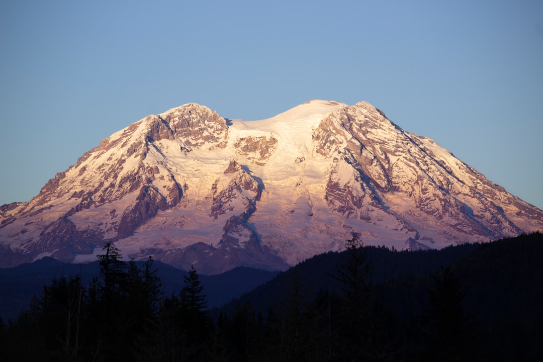
Mt. Rainier visibility is one of the most unpredictable things about living in or visiting the Pacific Northwest. The mountain stands 14,411 feet tall and dominates the southern skyline from Seattle, yet it hides behind clouds more often than not. Locals have a phrase for the rare days it appears: the mountain is out.
Understanding what controls visibility, when your odds are best, and how to check conditions before you go can mean the difference between a trip with jaw-dropping views and one spent staring at a wall of gray. Our real-time Mt. Rainier visibility forecast distills the atmospheric data into a single score, but the factors behind that score are worth knowing.
Table of Contents
- How Often Is Mt. Rainier Actually Visible?
- Mt. Rainier Visibility by Month
- Time of Day Matters More Than You Think
- What Controls Mt. Rainier Visibility
- Wildfire Smoke: The Expanding Threat to Summer Views
- How to Check Mt. Rainier Visibility Before You Go
- Frequently Asked Questions
How Often Is Mt. Rainier Actually Visible?
Mt. Rainier is visible from Seattle roughly 60 to 85 days per year, depending on how strictly you define "visible." A 2012 analysis using daily webcam captures from Kerry Park recorded 83 days with at least partial visibility, or about once every 4.4 days. A stricter count that required clear views of the full mountain dropped that number to 58 days, roughly once per week.
That means Rainier is hidden more than 75% of the time.
The National Park Service notes that visibility impairment at Mount Rainier National Park is among the highest of all monitored sites in the western United States. This is partly atmospheric, partly geographic. At 14,411 feet, Rainier intercepts moisture and clouds that pass far above the surrounding lowlands. The mountain is tall enough to create its own weather systems, wrapping itself in clouds even when Seattle enjoys blue sky.
For visitors planning around visibility, the takeaway is simple: never assume the mountain will be out. Check conditions the morning of your visit. That single habit will save you more disappointment than any seasonal strategy.
Mt. Rainier Visibility by Month
September offers the best Mt. Rainier visibility, followed closely by July, August, and May. Winter months are the least reliable, though post-storm clearings can produce the most dramatic views of the year.
The following table uses visibility day counts derived from the 2012 webcam analysis (3 PM daily captures from Seattle), combined with precipitation data from the NPS weather page.
| Month | Visible Days | Avg Precipitation | Visibility Rating |
|---|---|---|---|
| January | 6 | 11.7 inches | Poor |
| February | 5 | 8.2 inches | Poor |
| March | 2 | 7.5 inches | Very Poor |
| April | 4 | 5.7 inches | Below Average |
| May | 7 | 4.8 inches | Good |
| June | 4 | 3.9 inches | Below Average |
| July | 4 | 1.6 inches | Below Average |
| August | 7 | 1.5 inches | Good |
| September | 8 | 3.6 inches | Best |
| October | 5 | 7.9 inches | Average |
| November | 4 | 13.4 inches | Poor |
| December | 2 | 10.5 inches | Very Poor |
Some of these numbers are counterintuitive. July gets the least rain yet ties with June and November for visible days. The explanation is summer haze. On warm, sunny days, moisture evaporates into the lower atmosphere and creates a milky layer between you and the mountain. The sky looks blue overhead, but the horizon line is soft and washed out. Rainier disappears into the haze even though there are technically no clouds blocking it.
September wins because it combines low precipitation with cooler, drier air. Humidity drops, wildfire smoke (in years without major fires) often clears by mid-September, and the atmosphere tightens up. Colors sharpen. The mountain seems closer than it did all summer.
For a deeper dive into seasonal patterns, our best time to see Mt. Rainier guide breaks down viewing strategies month by month.
Time of Day Matters More Than You Think
The best time of day to see Mt. Rainier is early morning, typically before 10 AM. Visibility scores from our weighted atmospheric model consistently show higher readings in the pre-dawn and early morning hours compared to afternoon.
Here is why. As the sun heats the ground through the morning, warm air rises off valleys and lower slopes. This convective process generates cumulus clouds that build upward throughout the day, often wrapping the upper mountain by early afternoon. At Paradise (5,400 feet), rangers commonly describe mornings as clear and afternoons as cloudy, even in peak summer.
The pattern holds from Seattle too. Morning light also provides the sharpest contrast. The mountain catches the first sunlight while the foreground remains in shadow, making Rainier look almost impossibly bright against the darker sky. By afternoon, even on clear days, atmospheric scattering and haze reduce the contrast significantly.
If you are photographing the mountain, sunrise is the golden hour. If you are driving to the park from Seattle, leave early and plan to reach your viewpoint before the clouds build. An 8 AM arrival at Paradise gives you a fundamentally different experience than a 2 PM one.
What Controls Mt. Rainier Visibility
Four atmospheric factors determine whether you can see Mt. Rainier on any given day: cloud cover, humidity, wind patterns, and temperature inversions.
Cloud Cover
Cloud cover is the most obvious factor and the most common reason the mountain is invisible. Rainier generates orographic clouds through a straightforward process: moist Pacific air flows east, hits the mountain, rises, cools, and condenses. This happens regardless of the broader weather pattern.
Lenticular clouds are the signature formation. Shaped like flying saucers or stacked pancakes, they hover over the summit when moist air with consistent winds encounters the peak. Lenticular clouds form several times per month during fall and winter, and while they are visually spectacular, they signal that the summit is obscured. The University of Washington Atmospheric Sciences department publishes a recreational forecast that accounts for these mountain-specific cloud patterns.
Humidity and Haze
Even without clouds, high humidity degrades visibility. Water vapor in the lower atmosphere scatters light and creates haze that makes distant objects appear faded or invisible. This is why July, despite being dry by precipitation standards, often produces hazy views. Relative humidity in the Puget Sound lowlands regularly exceeds 70% on summer mornings before the marine layer burns off.
Dew point is a more useful metric than relative humidity for predicting haze. When the dew point sits above 55°F, expect reduced clarity. Below 45°F, the air is typically crisp enough for sharp views.
Wind Direction
Wind direction provides a useful visibility signal. Northerly or northeasterly winds bring dry continental air from British Columbia and produce excellent clarity. Southwesterly winds carry moisture from the Pacific and usually mean clouds or haze. The strongest visibility events often follow cold fronts, when dry Arctic air sweeps south behind a departing storm system. The 24 to 48 hours after a storm typically deliver the best views of the season, as our Mt. Rainier weather guide explains in detail.
Temperature Inversions
Temperature inversions create a unique and often stunning visibility scenario. Normally, temperature decreases with altitude. During an inversion, a warm air layer sits above cold valley air, trapping fog and low clouds below a specific elevation. If you are in the valley, you see nothing. But if you climb above the inversion layer, Rainier rises above a sea of white clouds, fully visible and brilliantly lit.
Crystal Mountain ski area, viewpoints along the Sunrise road, and higher trails within the park all sit above typical inversion levels. Winter inversions are most common from November through February. Checking the Mt. Rainier webcams at different elevations reveals whether an inversion is in play.
Wildfire Smoke: The Expanding Threat to Summer Views
Wildfire smoke has become the most significant emerging threat to Mt. Rainier visibility, primarily affecting August and September. In recent years, smoke from fires in Washington, Oregon, and British Columbia has reduced visibility to under 5 miles during severe episodes and triggered trail closures within the park.
The 2025 Wildcat Fire is a recent example. Burning over 7,500 acres east of the park in the Okanogan-Wenatchee National Forest, it sent heavy smoke into Mount Rainier National Park, forced trail closures along the Pacific Crest Trail, and pushed air quality into the "unhealthy" range. This is not an isolated event. Similar smoke impacts occurred in 2017, 2018, 2020, and 2024.
Smoke affects visibility differently than clouds. Clouds block the view entirely. Smoke degrades it gradually, turning the mountain into a faint ghost behind an orange-brown haze. On moderate smoke days, you might see Rainier's outline but lose all detail. On heavy smoke days, even nearby ridgelines vanish.
Before planning a late-summer visit, check the Washington Smoke Blog and the current AQI readings from the NPS monitors at Paradise and Longmire. If AQI exceeds 100, expect significantly reduced visibility. Above 150, the mountain will likely be invisible from Seattle even if the sky appears partly clear overhead.
The practical implication: early September used to be the secret local pick for the clearest mountain views. It still can be, but you now need a backup plan. Our Mt. Rainier recreational forecast factors in smoke conditions alongside standard weather data.
How to Check Mt. Rainier Visibility Before You Go
The most reliable approach to checking Mt. Rainier visibility combines a forecast tool with live camera confirmation.
Visibility Forecasts
Standard weather forecasts tell you about temperature and precipitation, but not whether the mountain will be visible. Our Mt. Rainier visibility page generates a 0-100 visibility score updated every 15 minutes, combining cloud cover, humidity, wind, precipitation, and atmospheric clarity into a single number. A score above 70 means excellent odds of seeing the summit. Below 40, expect the mountain to be hidden.
The UW Atmospheric Sciences recreational forecast provides a complementary perspective, combining regional weather models with local knowledge of how conditions develop on the mountain.
Live Webcams
Forecasts predict. Webcams confirm. The NPS webcam at Paradise shows current conditions at 5,400 feet, while the ismtrainierout.com timelapse captures daily visibility from Seattle. Checking both gives you a complete picture: what conditions look like at the mountain, and what conditions look like from where you are standing.
Our guide to Mt. Rainier webcams lists the best live camera feeds and explains what each angle reveals about current conditions.
The Morning-Of Rule
Mountain weather forecasts improve dramatically within 24 hours. A forecast made three days ahead is an educated guess. A forecast made the morning of your visit is reliable enough to act on. Check the visibility score when you wake up. If conditions look good, go. If they do not, find something else to do and check again tomorrow. Flexibility beats planning when it comes to mountain visibility.
For a full map of viewing locations and the best spots to see the mountain from Seattle, those guides will help you pick a destination once you have confirmed the mountain is out.
Frequently Asked Questions
Can you see Mt. Rainier from Seattle?
Yes, Mt. Rainier is visible from Seattle on clear days. The mountain sits roughly 60 miles southeast of downtown and dominates the southern skyline when conditions cooperate. The best vantage points include Kerry Park, Columbia Center Sky View Observatory, and the I-5 corridor south of the city. On average, Seattle residents can see Rainier about 60 to 85 days per year. Our guide to seeing Mt. Rainier from Seattle covers the best viewpoints in detail.
What month has the best Mt. Rainier visibility?
September consistently delivers the best Mt. Rainier visibility. It combines low precipitation, cooler temperatures that reduce haze, and typically clearer air after wildfire smoke dissipates. July and August are close runners-up, though summer haze can limit views even on rain-free days. For a full seasonal breakdown, see our best time to see Mt. Rainier guide.
Why can't I see Mt. Rainier even when the sky looks clear?
Haze is the most common culprit. High humidity in the lower atmosphere scatters light and makes distant objects fade into a milky backdrop, even under blue skies. This is especially common on warm summer afternoons when the dew point climbs above 55 degrees F. Wildfire smoke can produce a similar effect, turning the mountain into a faint outline or hiding it entirely while the sky overhead appears only slightly hazy.
Is there a way to check Mt. Rainier visibility right now?
Our Mt. Rainier visibility page provides a real-time score from 0 to 100, updated every 15 minutes. It combines cloud cover, humidity, wind, and atmospheric clarity into a single number. A score above 70 means excellent chances of seeing the summit. You can also check the NPS webcam at Paradise for a live view of current conditions at the mountain.
More Articles
Fuji Five Lakes: Which Lake Has the Best View of Mount Fuji
A data-backed guide to the Fuji Five Lakes: how each lake compares for Mt. Fuji views, timing, and access, so you pick the right one.
Kawaguchiko Village: Where Traditional Japan Meets Mt. Fuji Views
Explore Kawaguchiko village, its traditional neighborhoods, thatched-roof museums, and the best spots for clear Mt. Fuji views.
Lake Yamanaka from Tokyo: Every Route, Real Prices, and the Timing That Decides Your View
How to get to Lake Yamanaka from Tokyo by bus, train, or car, with current prices and the departure timing that matters most.