Tolmie Peak Lookout: Hike Guide, Access and Rainier Views
Tolmie Peak guide: the 6-mile lookout hike above Eunice Lake, why it has been unreachable since 2025, the backpacking way in, and Rainier's clear odds.

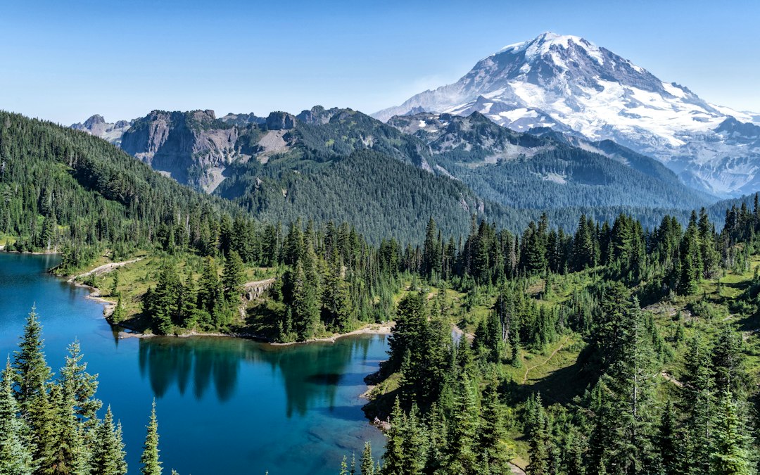
Tolmie Peak is a peak of about 5,900 feet in the northwest corner of Mount Rainier National Park, with a 1933 fire lookout that looks straight across Eunice Lake to Rainier. The hike starts at Mowich Lake and covers about 6 to 6.5 miles round trip with roughly 1,500 feet of total climbing. The park calls the lookout's view one of the best panoramic views of Mount Rainier available in the park.
You cannot drive to it right now. The Fairfax Bridge on SR 165, the only road to Mowich Lake, closed permanently on April 22, 2025, and it is closed to cars, bikes and people on foot. The National Park Service says there is "no alternate route". This guide covers what the bridge timeline looks like, the one legal way backpackers still reach Tolmie Peak, and what the trail and the view are like. The visibility odds come from a terrain model and ten years of modeled hourly weather that we analyzed for this post.
Can You Hike Tolmie Peak in 2026 or 2027?
No, not as a day hike. As of the park's October 16, 2026 trail conditions update, the Tolmie Peak row reads: "SR165 Carbon River/Fairfax Bridge is closed: no access to Carbon River or Mowich Lake." The same line covers Spray Park, Paul Peak, Green Lake and every other trail in the Carbon River and Mowich area.
The bridge itself is the bottleneck. WSDOT's January 2026 update moved two options into design and environmental review: build a new bridge just north of the old one, or keep SR 165 closed and remove the bridge. It put about $7 million toward that work and laid out the steps:
| Phase | WSDOT estimate |
|---|---|
| Soil and topographic surveys | 6 to 12 months, depending on tree-removal permits |
| Federal environmental review (NEPA) | About 24 months |
| Design and contracting after NEPA | 12 to 24 months |
| Construction | Not yet scheduled or funded |
Run those phases back to back from early 2026 and a construction contract lands somewhere between mid-2029 and early 2031. Building only starts after that. The Washington Trails Association reported in April 2026 that a replacement is estimated at $160 million, and no alternative has construction funding. The budget asked WSDOT to report back to the legislature by the end of 2026 so the cost can be considered in the 2027 session. The survey phase itself depends on environmental permits to remove trees in the Carbon River Canyon for test drilling.
So the honest outlook is this: a normal Tolmie Peak day hike is unlikely before the end of the decade, and it is not certain at all. Check the NPS Carbon River and Mowich page for changes. Do not trust routes around the bridge that show up in mapping services such as Google Earth. The park says those routes cross private land with locked gates.
How to Reach Tolmie Peak Without the Fairfax Bridge
The only legal way to Tolmie Peak today is on foot through the park, coming north on the Wonderland Trail from the Westside Road. It is a multi-day backpacking trip, about 19 miles each way on foot plus a 9-mile bike ride, and it needs a wilderness permit for every night you camp.
Here is the shortest route we can piece together from NPS and WTA trail distances:
| Leg | Distance | How |
|---|---|---|
| Dry Creek barricade to Klapatche Point | 9.2 mi | Bike or walk the closed Westside Road (NPS); bikes are not allowed on trails, so lock up at the trailhead rack |
| Klapatche Point to North Puyallup River camp | 2.7 mi | North Puyallup Trail, nearly flat (NPS) |
| North Puyallup River to Mowich Lake | About 13.5 mi | Wonderland Trail past Golden Lakes and the North and South Mowich river crossings (WTA) |
| Mowich Lake to Tolmie Peak Lookout | About 3 mi | The normal day-hike trail |
That is roughly 38 miles round trip on foot, with real climbing on the Wonderland between the Puyallup and Mowich rivers, plus 18.4 miles of road riding. Designated camps along the way include North Puyallup River, Golden Lakes, South Mowich River and Mowich Lake. The North and South Mowich are swift glacial rivers, and the North Mowich has a log bridge; WTA suggests crossing early in the day, because the water rises as the day goes on.
Two cautions. The northern approach, the Wonderland from Carbon River, is closed between Carbon River and Summerland because of the 2026 Grand Park 2 and Garda Falls fires, and the park has said it will not issue full Wonderland circuit permits until further notice (NPS trail conditions). And the Tolmie Peak and Eunice Lake area is closed to overnight camping, so the lookout is a side trip from Mowich Lake camp, not a place to sleep. Our Wonderland Trail guide covers permits and the lottery in detail.
Tolmie Peak Hike at a Glance
The Tolmie Peak trail is an out-and-back hike of moderate difficulty from the north end of Mowich Lake, with most of the climbing in the last three quarters of a mile. Published distances disagree more than usual, so we measured the mapped trail ourselves.
| Detail | Figure | Source |
|---|---|---|
| Distance | 6.5 mi round trip (WTA lists 7.5 mi) | NPS, WTA |
| Mapped trail length | 2.96 mi one way, about 5.9 mi round trip | Our measurement of the OpenStreetMap trail line |
| Elevation gain | About 1,240 ft out, 290 ft back, about 1,500 ft total | Our terrain model; WTA lists 1,100 ft |
| Start | Mowich Lake, about 4,950 ft | NPS lists Mowich Lake walk-in camp at 4,900 ft |
| High point | Lookout about 5,900 ft; the true summit, a short scramble east, is about 60 ft higher | Terrain model |
| Season (when the road is open) | Mowich area generally mid-July to mid-October | NPS |
| Dogs | Not allowed | NPS pets |
| Camping | None at the lookout or Eunice Lake | WTA |
Differences between published distances likely come from where the measurement starts and whether it includes the short walk out to the true summit. Plan on about 6.5 miles and three to four hours with time on top.
The Tolmie Peak Trail, Mile by Mile
The Tolmie Peak trail has three parts: a nearly flat mile along Mowich Lake, a dip past Ipsut Pass, and a steep finish above Eunice Lake. Mileposts and elevations below come from our terrain profile of the mapped route. WTA's trail description gives somewhat longer distances, so treat them as approximate.
Mowich Lake to Ipsut Pass (0 to 1.4 miles). You follow the Wonderland Trail along the west shore of Mowich Lake, then climb gently through hemlock and fir to about 5,100 feet. At the Ipsut Pass junction the Wonderland drops right toward the Carbon River. Take the short detour to the pass for a look straight down the Ipsut Creek valley, then come back and go left.
The dip (1.4 to 1.8 miles). This is the part that surprises people. The trail loses about 200 feet below basalt cliffs, bottoming out near 4,900 feet. You will pay it back on the way home.
Eunice Lake (around 2.2 miles). Switchbacks bring you up into the lake basin at about 5,360 feet. Meadows ring the shore. Stay on the trail; the meadows here are fragile. On a clear day Rainier fills the sky over the far end of the lake, but the classic framed view is still above you.
The final climb (2.2 to 3.0 miles). The last three quarters of a mile gains about 540 feet. It curls around the north side of the peak, so you look down the Carbon River valley before the trail swings back to the lookout and the full view opens.
Our terrain model puts Rainier's summit in line of sight from just past Ipsut Pass all the way to the top. Forest hides it for most of that stretch, though. The open views begin at Eunice Lake.
What You Can See from Tolmie Peak Lookout
From the Tolmie Peak Lookout, Mount Rainier's summit sits 9.2 miles away to the southeast, rising about 10 degrees above the horizon. That is roughly four and a half times taller in your field of view than it looks from Kerry Park in Seattle, where it stands about 2 degrees high. Along the direct line, you see the mountain from around 6,500 feet up to the top, close to 8,000 vertical feet of rock and ice in one frame, with Eunice Lake in the foreground.
We ran a terrain line-of-sight test from the lookout to the other big peaks on the horizon. It uses a 30-meter elevation model with standard atmospheric refraction, so treat the far-away results as model estimates rather than guarantees:
| Target | Distance | Direction | Result |
|---|---|---|---|
| Mount Rainier summit | 9.2 mi | SE (142°) | Visible, about 10° above the horizon |
| Mount St. Helens | 55 mi | SSW (196°) | Visible |
| Glacier Peak | 87 mi | NNE (24°) | Visible, thin margin |
| Mount Baker | 126 mi | N (1°) | Visible, thin margin |
| Mount Olympus | 104 mi | WNW (305°) | Just grazes the horizon; the Olympic range is in view |
This matches the NPS description, which names St. Helens, the Olympics and Baker. Baker and Glacier Peak clear the intervening ridges by only a fraction of a degree, so any haze or wildfire smoke erases them first.
For comparison, from the Mount Fremont Lookout on the opposite corner of the park, Rainier is 6.9 miles away and 11 degrees high.
When Rainier Is Clear from Tolmie Peak
Late July is the best time for a clear Rainier from Tolmie Peak. In the second half of July, the summit had a clear window of at least three hours on 82% of days in our 2016 to 2025 data, and the lookout itself sat in cloud on only 7% of days.
We pulled hourly cloud cover for Rainier's summit and for the model cell over Tolmie Peak from the Open-Meteo historical archive, 2016 to 2025. A "clear window" means three straight hours between 7 AM and 7 PM with summit cloud cover at 30% or less and low cloud over the lookout at 50% or less. "In cloud" means low cloud above 80% for at least three of the five hours from 10 AM to 2 PM. These are modeled grid values, not observations from the lookout; the Tolmie cell is centered a few miles southeast of the peak.
| Period | Clear window | Clear at least one hour | Lookout in cloud at midday |
|---|---|---|---|
| July 1 to 15 | 60% | 76% | 17% |
| July 16 to 31 | 82% | 89% | 7% |
| August 1 to 15 | 72% | 85% | 11% |
| August 16 to 31 | 64% | 78% | 9% |
| September 1 to 15 | 55% | 69% | 14% |
| September 16 to 30 | 46% | 62% | 27% |
| October 1 to 15 | 48% | 56% | 25% |
| October 16 to 31 | 29% | 42% | 41% |
A few patterns stand out:
- Mornings beat afternoons. From mid-July to mid-September, about 58 to 60% of hours from dawn to 10 AM were clear by our test, against about 50% at 2 PM. The evening recovers a little, to about 55% by 8 PM.
- The 8 AM sky is a strong signal. On days clear at 8 AM, it was still clear at 11 AM roughly 8 times in 10 and at 1 PM about 7 times in 10. On days hidden at 8 AM, only about 1 in 5 were clear at 11 AM.
- Years vary a lot. The share of mid-July to mid-September days with a clear window ranged from about half in 2019 to roughly four in five in the best years.
- Fall gets cold and windy up top. Median 1 PM temperature in the lookout cell was about 62°F in July and 64°F in August, but 42°F in October, when gusts topped 30 mph on 22% of afternoons.
Before you commit to a long drive or a multi-day trip, check the live Mount Rainier visibility forecast. It scores the summit with a weighted atmospheric model and shows the next ten days, so you can line your lookout day up with a clear one. The Rainier webcams show what the summit is doing right now.
Morning or Sunset at Tolmie Peak?
Sunset gives the best light on Rainier from Tolmie Peak, because you face southeast and the setting sun lands behind your right shoulder. The catch is that mornings are clearer, and evening means hiking out in the dark.
We computed the sun's position from the lookout. Between mid-July and early October, the sun passes Rainier's bearing between about 11 AM and noon. For the late morning and midday, the face you see is backlit and flat. At sunset the sun sits in the west-northwest. In mid-July it sets less than 20 degrees from directly behind you, which puts warm, front-on light on the mountain and the lake. By October 1 the sun sets almost due west, about 55 degrees from directly behind you, and the light comes in more from the side.
Since there is no camping at the lookout, a sunset visit means about three miles back to Mowich Lake by headlamp. The trail is well defined, but bring a real light and plan on going slowly on the dip below Ipsut Pass. Mowich Lake Campground, at the trailhead, is the obvious base for a dawn start. Our Rainier sunset guide explains alpenglow timing in more detail.
Fire Lookouts You Can Reach Instead
Mount Rainier National Park has four surviving fire lookouts, and while Tolmie Peak is cut off, one of the other three is the best substitute: Gobblers Knob, which also has a lake below it.
| Lookout | Trailhead | Round trip | Gain | 2026 status |
|---|---|---|---|---|
| Gobblers Knob | Westside Road at Dry Creek, via Round Pass and Lake George | 12.3 mi | 2,565 ft | Reachable; the closed road section can be biked |
| Shriner Peak | SR 123, east side | 8.5 mi | 3,434 ft | Reachable when SR 123 is open; steep and hot |
| Mount Fremont (1934) | Sunrise | 5.6 mi | 1,200 ft | Trail closed by the 2026 Grand Park 2 Fire |
| Tolmie Peak (1933) | Mowich Lake | 6.5 mi | ~1,500 ft | No public access since April 2025 |
Distances and gain are from WTA (Gobblers Knob, Shriner Peak) and the NPS Dry Creek page, which puts Round Pass 3.8 miles up the road, Lake George 0.8 mile past that and the lookout one steep mile beyond the lake.
Gobblers Knob is the closest match in feel: a 1930s lookout, a subalpine lake on the way and Rainier filling the view to the northeast. Riding a bike to Round Pass cuts most of the road walking. If you want something shorter with a lake and a Rainier reflection but no lookout, see our guides to Reflection Lakes and Tipsoo Lake. The park-wide hiking guide sorts the open trails by area.
Tolmie Peak History and the Name
The Tolmie Peak Fire Lookout was built in 1933 and is one of four left in the park, out of seven that stood in the 1930s. Its design was prepared under the supervision of Edwin A. Nickel of the NPS Branch of Plans and Designs. The new building lost its roof in a windstorm and is still held down by cables anchored to buried deadmen. It was listed on the National Register of Historic Places on March 13, 1991.
The peak is named for William Fraser Tolmie, a 21-year-old Hudson's Bay Company doctor at Fort Nisqually. In 1833 he traveled toward Rainier with five Indigenous guides to collect medicinal plants. On the fifth day they climbed a peak long thought to be this one. The National Park Service now says it was "probably Hessong Rock in Spray Park," a few miles southeast.
What to Do If Tolmie Peak Is on Your List
Treat Tolmie Peak as a future trip, not a next-summer plan. Three practical moves:
- Watch the bridge, not the trail. Bridge funding could be taken up in the 2027 legislative session. WSDOT's SR 165 updates and the NPS Carbon River page will show any change first.
- If you backpack, go in late July or August. That is when Mowich-area snow is gone, the Mowich rivers are lower than in early summer, and the summit had a clear window on 64 to 82% of days in our data. Get a wilderness permit for every camp.
- For a day hike, do Gobblers Knob. It gives you the same kind of view, a 1930s lookout over a lake, from a trailhead you can still reach by car and bike.
Whichever you pick, open the Mount Rainier visibility forecast the night before. A lookout hike in cloud is just a walk in the woods.
More Articles
Mount Fremont Lookout: Hike Guide, Views and Clear-Sky Odds
Mount Fremont Lookout guide: the 5.6-mile hike from Sunrise, the 2026 fire closure, which volcanoes you can see and when Rainier is clear.
Hikes in Mount Rainier National Park: Best Trails by Area
Hikes in Mount Rainier National Park by area, with 2026 closures, snow-free timing and the odds of a clear summit by month and hour.
Mount Rainier Wonderland Trail: Permits, Route and Odds
Mount Rainier Wonderland Trail guide: the 93-mile loop, permits, the 61-mile food carry since Mowich closed, camp melt-out and 10-day cloud odds.