Tipsoo Lake Mt. Rainier: Reflection Guide, Trail & Best Time
Tipsoo Lake at Mt. Rainier delivers the park's best east-side reflection. Learn the road window, where the mirror really is, and when to go.

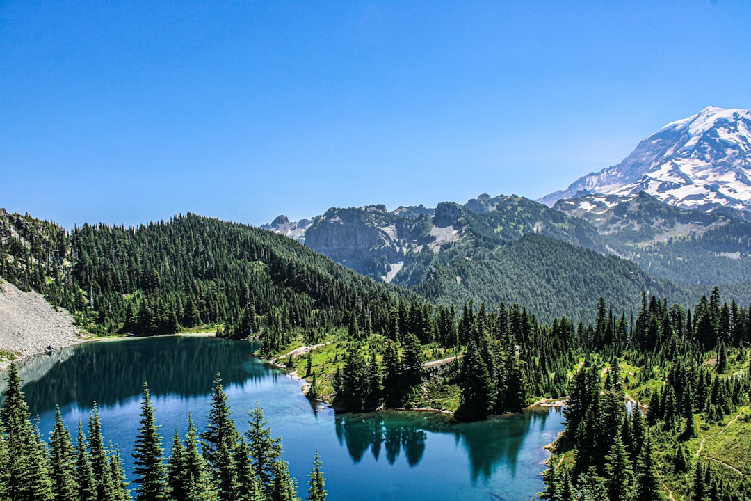
Tipsoo Lake at Mt. Rainier is a subalpine tarn perched at 5,298 feet just below Chinook Pass, on the far eastern edge of the national park. On a still, clear morning it holds a mirror image of the 14,411-foot summit framed by wildflower meadows, which is why it ranks among the most photographed spots in the park. But two things decide whether your visit works: whether the road is even open, and whether the mountain is out at all. Before you commit to the drive, check the live Mount Rainier visibility forecast to see if the peak will show.
Table of Contents
- Where Is Tipsoo Lake at Mt. Rainier?
- The Road Window That Decides Everything
- Will Mt. Rainier Actually Be Reflected?
- Upper vs Lower Tipsoo Lake: Where the Mirror Really Is
- The Naches Peak Loop
- Best Time to Visit Tipsoo Lake
- Parking, Fees, and Practical Tips
- When the Mountain Is Hidden: A Plan B
- Frequently Asked Questions
Where Is Tipsoo Lake at Mt. Rainier?
Tipsoo Lake sits on the eastern border of Mount Rainier National Park, about half a mile below the 5,430-foot summit of Chinook Pass along State Route 410. At 5,298 feet, it is a glacier-carved basin ringed by subalpine meadows, and it is one of the highest and most easily reached alpine lakes in the park. The National Park Service describes it as a place for wildflowers, huckleberries, and brilliant autumn color, with picnic tables, benches, and vault toilets right by the water.
The name comes from Chinook Jargon, the old trade language of the Pacific Northwest. In that tongue, "tipso" means grass, leaves, or foliage, so Tipsoo translates loosely to "grassy." Anyone who visits in late July, when the surrounding meadows explode with lupine and paintbrush, will understand why the name stuck.
What sets Tipsoo apart from the park's other famous reflection spot is its position. It sits east of the summit, on the opposite side of the mountain from Paradise. The more famous Reflection Lakes lie on Stevens Canyon Road to the south. Because Mount Rainier generates its own weather, the east side can be clear while the Paradise corridor is buried in cloud, and the reverse happens just as often. That difference matters more than most guides admit.
The Road Window That Decides Everything
The single biggest constraint at Tipsoo Lake is not the weather on any given day. It is whether the road is open at all. State Route 410 over Chinook Pass, along with SR 123 over Cayuse Pass, closes every winter because of deep snow and avalanche danger, and it stays shut for roughly half the year.
For the 2026 season, the Washington State Department of Transportation reopened both passes by 8 a.m. on Friday, May 22, in time for Memorial Day weekend. The closure date shifts with the first heavy snows but typically lands in mid-November. So the realistic drive-up window is roughly late May through mid-November.
That is the outer boundary. The window for what most people actually come for, snow-free meadows and a clean reflection, is narrower still. Snow lingers at 5,300 feet well into summer, so the ground around the lake and the loop trail is usually clear only from mid-July through mid-October. Show up in early June and you may find the road open but the lake half-frozen and the meadows under a foot of snow.
This is the detail that trips up first-time visitors. They see a summer itinerary online, drive two hours east from the Seattle area, and arrive to a locked gate or a snowbank. Confirm the pass status before you leave, and treat the official park map as your reference for how the east-side entrances connect. Chinook Pass is a completely different approach from the Nisqually Entrance most visitors use.
Will Mt. Rainier Actually Be Reflected?
The reflection only appears when Mount Rainier is genuinely out, and that is far from a sure thing. This is the part nearly every Tipsoo Lake guide skips. The summit is fully clear only about 20 to 30 percent of the year. The rest of the time, cloud caps the peak, and a glassy lake mirrors nothing but gray.
Think through what that means. You can drive up on a windless dawn, find Tipsoo perfectly still, and still walk away with no mountain, because the summit is wrapped in its own cloud even while your valley is clear. A reflection lake is only ever as good as the thing it is trying to reflect.
This is exactly the gap our tool closes. The real-time Mount Rainier visibility score comes from a weighted atmospheric model that blends cloud cover, humidity, precipitation probability, and atmospheric visibility distance, updated every 15 minutes and forecast 10 days out. Instead of gambling on a pre-dawn drive over a mountain pass, you can check whether the peak is expected to be out before you set the alarm.
There is an east-side wrinkle worth knowing. From Tipsoo you look southwest toward Rainier, so at sunrise the mountain's face catches the first light while you shoot into soft, warm alpenglow. That geometry is a gift when the summit is clear. It also means an east-side forecast can diverge from what people report at Paradise, so read the visibility score for the mountain itself rather than assuming the whole park shares one sky. For the underlying reason the peak hides so often, our Mount Rainier weather guide breaks down the Pacific maritime patterns at play.
Upper vs Lower Tipsoo Lake: Where the Mirror Really Is
Here is the insider detail that separates a snapshot from the shot: there are effectively two Tipsoo lakes, and the postcard reflection does not come from the one beside the parking lot. The larger lower lake sits right at the road by the picnic area. It is lovely, but trees and the roadside angle limit the classic composition.
The cleanest mirror comes from Upper Tipsoo Lake, a smaller tarn reached by walking a few minutes up the paved path and onto the Naches Peak Loop. From the meadow rim above the upper lake, the mountain lines up over the water with wildflowers in the foreground and no road in the frame. Most photographers you see with tripods at dawn have walked up here, not stopped at the lot.
Give yourself 10 to 15 minutes to walk in and find the angle in the dark if you are chasing sunrise. The reward for that short effort is the difference between "a lake near Rainier" and the composition that made Tipsoo famous.
The Naches Peak Loop
The best way to see Tipsoo Lake is on the Naches Peak Loop, a 3.4-mile trail that circles Naches Peak with roughly 600 feet of elevation gain. It is on the easy end of moderate and takes most people around two hours. Per the Washington Trails Association, the loop is best hiked clockwise, which keeps Mount Rainier in front of you for the scenic western half.
The route is a genuine two-park hike. Part of it follows the Pacific Crest Trail across Wenatchee National Forest land on the eastern flank, and the other half runs inside Mount Rainier National Park. That split has a practical consequence: dogs are allowed on the national forest portion but not inside the park boundary, so the loop is effectively off-limits to pets. The park's Naches Peak page confirms the trail is typically snow-free from mid-July through mid-October.
Beyond the Rainier views, the loop passes a second alpine tarn on its eastern side and, in a good year, some of the densest wildflower meadows in the whole park. If you only have time for the highlight, a short out-and-back from the Tipsoo lot up to the meadow above Upper Tipsoo delivers most of the payoff in under a mile.
Best Time to Visit Tipsoo Lake
The best time to visit Tipsoo Lake is at sunrise from mid-July through early October, when the road is open, the meadows are clear, and the morning air is calm. Season and time of day pull in different directions, and both matter.
For flowers, aim for late July into early August, when the NPS notes peak bloom typically arrives. Lupine, magenta paintbrush, and partridgefoot fill the basin and give the reflection a foreground. For color of a different kind, come in mid to late September, when the huckleberry understory turns crimson and gold across the slopes. Fall at Tipsoo is quieter than the wildflower crush and, on a clear day, every bit as striking.
Time of day is where the reflection lives. The lake is glassiest in the hour around dawn, before thermal winds ripple the surface, and that is also when the summit glows with alpenglow. Photographers routinely arrive before first light to claim their spot. For golden-hour timing across the park, our Mount Rainier sunrise guide lays out the numbers, and our best time to see Mount Rainier guide maps the visibility odds month by month.
Parking, Fees, and Practical Tips
Tipsoo Lake has a modest roadside lot at the picnic area plus additional parking up at the Chinook Pass trailhead where the loop crosses SR 410. Both fill early on clear summer weekends. If the reflection is your goal, plan to arrive in the dark; by sunrise on a July Saturday the spots are gone and tripods already line the best angles.
Good news for 2026: Mount Rainier National Park is not requiring timed-entry reservations this year for any area. You pay the standard entrance fee, $30 per private vehicle valid for seven consecutive days, and drive in. Note that Tipsoo straddles two land agencies, so a park pass covers you inside the boundary while the forest side falls under a Northwest Forest Pass; the vehicle entrance fee is the simplest way to be covered for the whole loop.
A few field notes. Swimming is prohibited to protect the fragile shoreline vegetation, so this is a look-but-do-not-touch lake. Pack warm layers even in August, because at 5,300 feet a clear dawn can sit near freezing. And cross-reference the forecast with a Mount Rainier webcam the morning of, which is the most reliable way to confirm the summit is out before you drive the pass.
When the Mountain Is Hidden: A Plan B
Because Tipsoo depends entirely on the summit being visible, the smartest move is to let the forecast decide your plan rather than the other way around. Check the current visibility score the night before and again at your alarm.
If the mountain is out, get to Upper Tipsoo before dawn and let the summit light up over still water. If the score is low, you have options that do not hinge on the peak. The wildflower and huckleberry meadows along the loop are gorgeous under overcast, and the east-side forests care nothing for whether Rainier is showing. On the drive up from the Nisqually side, weather-proof stops like Narada Falls thunder regardless of the summit, and the Paradise meadows deliver even when the mountain hides.
This is the piece most Tipsoo Lake guides leave out. They describe the perfect mirror without telling you how rarely the conditions line up, or what to do on the 70 to 80 percent of days when they do not. If you want to gauge the odds from the lowlands first, our guide on whether the mountain is out over Seattle explains how to read conditions before you commit to the drive.
Frequently Asked Questions
How long is the Tipsoo Lake trail?
The short paved loop around Lower Tipsoo Lake is under a mile and mostly flat. The full Naches Peak Loop, which circles Naches Peak and passes Upper Tipsoo, runs 3.4 miles with about 600 feet of elevation gain and takes roughly two hours at an easy pace.
When does Chinook Pass open for Tipsoo Lake access?
SR 410 over Chinook Pass typically reopens in late May, after crews clear the winter snow, and closes again around mid-November. In 2026 it reopened by 8 a.m. on May 22. The meadows and reflection are usually best from mid-July through mid-October once the snow around the lake has melted.
Can you swim in Tipsoo Lake?
No. Swimming is prohibited at Tipsoo Lake to protect the fragile subalpine shoreline and meadow vegetation. It is a viewing, hiking, and photography destination, and visitors are asked to stay on designated trails around the water.
Is Tipsoo Lake worth visiting?
Yes, especially if you time it for a clear summer or early-fall morning. On a calm day with the summit out, Upper Tipsoo delivers one of the finest reflections in the park with minimal effort. Just remember Mount Rainier is fully visible only 20 to 30 percent of the year, so check the live visibility forecast before you go.
Plan Your Tipsoo Lake Morning
Tipsoo Lake rewards planning more than luck. The road is only open half the year, the meadows are clear for a narrower window still, and the reflection appears only when the summit cooperates and the water goes glass-flat at dawn. Line those up and you get a view that justifies the early alarm and the drive over the pass.
Check the Mount Rainier visibility forecast the night before. If the score is high, walk up to Upper Tipsoo in the dark and watch the mountain catch fire in still water. If it is low, save the pass for another day and let the meadows, the huckleberries, or a lower-elevation waterfall carry the trip instead.
More Articles
Reflection Lake Mt. Rainier: The Perfect Mirror Shot Guide
Reflection Lake at Mt. Rainier is the park's most photographed view. Learn when the mirror actually works, parking, trails, and reflection timing.
Best Time to See Mt. Rainier: Seattle Visibility Guide by Month
Find the best time to see Mt. Rainier from Seattle with monthly visibility data. Learn when "the mountain is out" and how to plan your visit for clear views.
Narada Falls: Mount Rainier's Roadside Waterfall Guide
Narada Falls is Mount Rainier's largest drive-up waterfall. Get directions, the trail, the best time to visit, and rainbow-viewing tips.