36 Views of Mount Fuji: Where Hokusai Stood, Mapped
Hokusai's 36 Views of Mount Fuji mapped to real places, with the distance, direction and terrain check for whether Fuji is still visible from each.

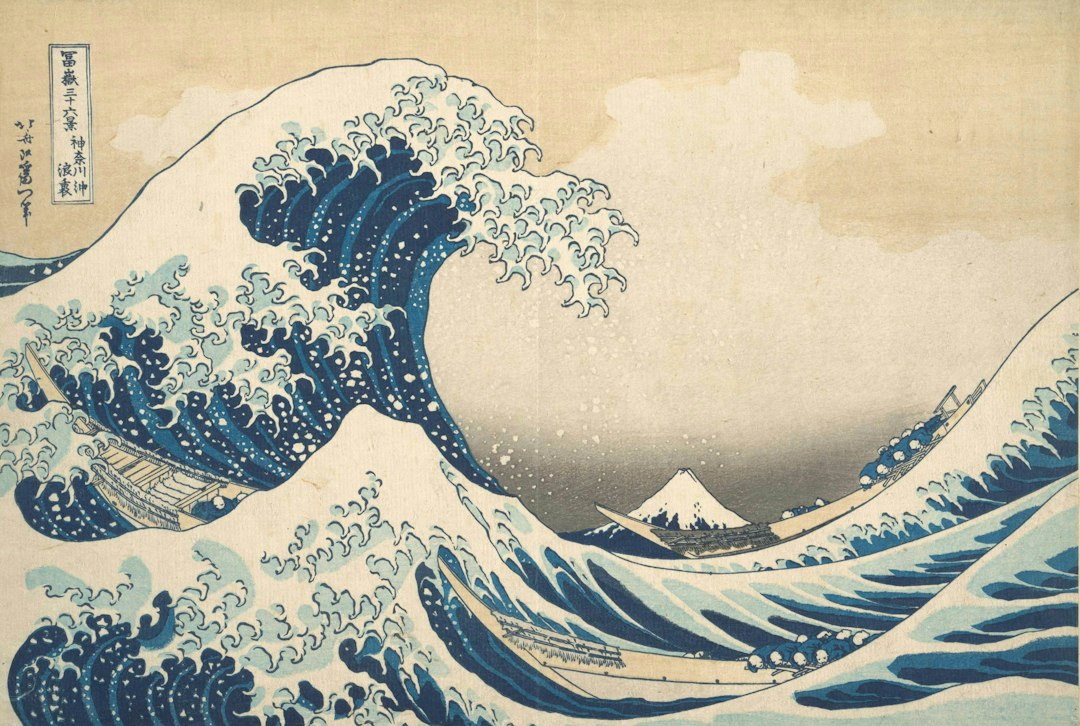
Hokusai's 36 Views of Mount Fuji (Fugaku Sanjūrokkei) is a series of 46 woodblock prints made around 1830 to 1832, each showing Mt. Fuji from a different place, season or kind of weather. The great majority were drawn from named places you can still visit. We matched every print that has a location to its modern site and ran a terrain line-of-sight check from each one. That gives the distance to the summit, which way you face, how high the peak sits above the horizon, and whether the land in between still lets you see it.
The short answer: most of Hokusai's viewpoints still work, a few never could have, and the mountain in nearly all of them hides on more days than it shows. Before you go looking for one, check the live Mt. Fuji visibility forecast.
What the 36 Views of Mount Fuji Actually Are
The 36 Views of Mount Fuji are 46 landscape prints by Katsushika Hokusai (1760-1849), published in Edo by Nishimuraya Yohachi when the artist was about 70. The first 36 sold so well that ten more were added. Collectors call those ten the ura Fuji, or "Fuji from the back," and they are usually told apart by outlines printed in black rather than blue.
That blue matters. Many of the early prints were aizuri-e, printed mostly in imported Prussian blue, a synthetic pigment that was then new and fashionable in Edo.
Three prints carry the series' fame: The Great Wave off Kanagawa, Fine Wind, Clear Morning (the "Red Fuji") and Thunderstorm Beneath the Summit. The Great Wave alone is now on the reverse of the 1,000-yen note issued from July 2024, and Japanese passports issued on applications from February 2020 carry prints from the series on their visa pages, 24 designs in the 10-year passport and 16 in the 5-year one.
One name clash to clear up: Hiroshige made two Thirty-six Views of Mount Fuji series of his own, a small horizontal set around 1852 and the better-known vertical set designed in 1858, the year he died. Different artist, different viewpoints. Everything below refers to Hokusai's set.
How We Mapped the Viewpoints
Each site comes from the print's title and published museum identifications, placed at modern coordinates. Where the exact spot is unknown, we used the town or landmark the title names and say so.
For every site we calculated the great-circle distance and compass bearing to Fuji's 3,776 m summit, and the summit's height above the horizon after correcting for Earth's curvature and standard atmospheric refraction. Then we traced a profile across the Geospatial Information Authority of Japan's elevation tiles, built from its 10 m elevation model and read here at about 30 m resolution, sampling every 100 m, to see whether a ridge gets in the way. Where the exact point was blocked, we tested a grid of nearby points to see whether any ground within 1 to 4 km still has a view.
Three limits apply. These are model results, not field checks, and a coarser grid can miss a narrow ridge or a small gap. This is bare terrain, so it ignores buildings and trees, which matter a lot in Tokyo. And a clear sightline only means the mountain can be seen. Whether it is seen on a given day is a weather question.
The Edo Prints: 17 Views From Today's Tokyo
Seventeen of the 46 prints were made in Edo, today's central Tokyo, and all of them sit 93 to 107 km from the summit. From every one of these sites Fuji lies between 246° and 253°, which is west-southwest, and its peak stands only 1.6° to 1.9° above the horizon. That is about the width of your thumb held at arm's length.
The terrain is clear from all of them. The Tanzawa mountains, the nearest high ground, sit some 53 to 67 km out on that line and still leave 700 to 1,250 m of Fuji showing above them. What blocks the view now is the city.
| No. | Modern location | Distance to summit | |
|---|---|---|---|
| 4 | Under Mannen Bridge at Fukagawa | Kiyosumi, Koto | 103 km |
| 5 | Surugadai in Edo | Kanda-Surugadai, Chiyoda | 101 km |
| 6 | The Cushion Pine at Aoyama | Ryugan-ji, Jingumae, Shibuya | 96 km |
| 7 | Senju in Musashi Province | Senju, Adachi | 107 km |
| 11 | Honganji Temple at Asakusa | Higashi Honganji, Nishi-Asakusa | 104 km |
| 12 | Tsukuda Island | Tsukuda, Chuo | 102 km |
| 21 | Mitsui Shop at Suruga-chō | Nihonbashi-Muromachi (Mitsukoshi) | 101 km |
| 22 | Sunset Across Ryōgoku Bridge | Kuramae, Taito | 104 km |
| 23 | Sazaidō at Gohyaku Rakan-ji | Original temple site, Ōjima, Koto | 107 km |
| 24 | Morning After a Snowfall at Koishikawa | Koishikawa, Bunkyo | 100 km |
| 25 | Shimomeguro | Shimomeguro, Meguro | 94 km |
| 26 | Watermill at Onden | Jingumae, Shibuya | 95 km |
| 31 | Nihonbashi in Edo | Nihonbashi bridge, Chuo | 101 km |
| 32 | Sekiya Village on the Sumida River | Senju-Sekiya, Adachi | 107 km |
| 37 | Tatekawa in Honjo | Tatekawa, Sumida | 104 km |
| 38 | Fuji from the Senju pleasure quarter | Senju, Adachi | 107 km |
| 39 | Gotenyama at Shinagawa | Kita-Shinagawa, Shinagawa | 96 km |
Look at the Fuji in these prints. It is small, often a little white triangle on the skyline, which is honest. At about 100 km the mountain really is a minor feature, and Hokusai drew it that way. Today you get these views from high floors and bridges rather than from street level. Our guide to seeing Mt. Fuji from Tokyo covers the observation decks that line up with this same bearing.
Every Other 36 Views of Mount Fuji Location
The remaining 25 located prints spread across seven prefectures plus western Tokyo, and the geometry changes a lot from one to the next. The summit stands 11.6° above the horizon at Kagosaka Pass and barely half a degree at Ushibori, the width of the full moon.
| No. | Modern location | Distance | Fuji lies | Summit above horizon | Terrain sightline today | |
|---|---|---|---|---|---|---|
| 1 | The Great Wave off Kanagawa | Sea off Kanagawa, Yokohama | 87 km | W | 2.1° | Yes |
| 8 | Tama River in Musashi | Tama River, Fuchu area (approx.) | 75 km | WSW | 2.6° | Yes |
| 9 | Inume Pass in Kai | Inume, Uenohara, Yamanashi | 40 km | SW | 4.5° | Yes at the old post town; patchy nearby |
| 10 | Fujimigahara in Owari | Fujimi-chō, Naka-ku, Nagoya | 167 km | E | 0.6° | No |
| 13 | Shichirigahama in Sagami | Shichirigahama, Kamakura | 72 km | W | 2.7° | Yes |
| 14 | Umezawa in Sagami | Ninomiya, Kanagawa | 48 km | W | 4.2° | Yes, from most of the area |
| 15 | Kajikazawa in Kai | Fujikawa Town, Yamanashi | 30-32 km | SE | 6.0-6.4° | Not from the gorge floor; yes from higher ground |
| 16 | Mishima Pass in Kai | Kagosaka Pass, Yamanakako | 13 km | WSW | 11.6° | Yes |
| 17 | Lake Suwa in Shinano | Lake Suwa, Nagano | 96-98 km | SE | 1.4° | Yes |
| 18 | Ejiri in Suruga | Shimizu, Shizuoka City | 44 km | NNE | 4.7° | Yes |
| 20 | Ushibori in Hitachi | Itako, Ibaraki | 175 km | WSW | 0.55° | Yes |
| 27 | Enoshima in Sagami | Enoshima / Katase, Fujisawa | 69 km | W | 2.9° | Yes |
| 28 | Tago Bay near Ejiri | Tagonoura coast, Fuji City | 25 km | N | 8.5° | Yes |
| 29 | Yoshida on the Tōkaidō | Toyohashi, Aichi | 138 km | ENE | 1.0° | Only from a few spots |
| 30 | The Kazusa Sea Route | Tokyo Bay off Chiba | 102 km | W | 1.7° | Yes |
| 33 | Noboto Bay | Chiba City shore | 129 km | WSW | 1.2° | Yes |
| 34 | Lake Hakone in Sagami | Lake Ashi, Hakone | 33 km | NW | 5.2° | Yes |
| 35 | Reflection in Lake at Misaka | Misaka Pass above Lake Kawaguchi | 22 km | S | 5.8° | Yes |
| 36 | Hodogaya on the Tōkaidō | Hodogaya, Yokohama | 78 km | W | 2.4° | Yes |
| 40 | Nakahara in Sagami | Nakahara, Hiratsuka | 55 km | W | 3.7° | Yes |
| 41 | Isawa at Dawn | Isawa Onsen, Fuefuki | 34 km | SSE | 5.7° | Yes |
| 42 | Fuji from the Minobu River | Minobu, Yamanashi | 25 km | E | 8.1° | Not from the valley |
| 43 | Ōno Shinden in Suruga | Ōno-shinden, Fuji City | 24 km | N | 8.7° | Yes |
| 44 | Katakura Tea Fields | Katakura, Fuji City (approx.) | 18 km | NNE | 11.1° | Yes |
| 45 | Fuji from Kanaya on the Tōkaidō | Kanaya, Shimada | 81 km | NE | 2.3° | Yes |
Four prints have no fixed viewpoint. Fine Wind, Clear Morning (2) and Thunderstorm Beneath the Summit (3) show the mountain itself. In the Mountains of Tōtōmi (19) names only a province. Climbing Mt. Fuji (46) is set on the slope.
Three Views the Terrain Does Not Allow
Three of the 46 prints show Fuji from places where, by our terrain model, the summit is hidden at ground level. A fourth shows it from a town where only a few spots have a line of sight.
Fujimigahara, Nagoya (print 10). This is the cooper inside a giant barrel, with a tiny Fuji framed in the hoop. The site is not certain, but the usual identification is Fujimi-chō in Naka Ward, Nagoya, 167 km from the summit. A Nagoya City Library research report notes that Edo-period sources disagreed on whether Fuji could be seen from Nagoya, and that later surveys concluded it cannot. The profile runs into a 2,000 m ridge at the southern end of the Akaishi Mountains (the Southern Alps), about 100 km out. It hides the summit by some 300 m. Raising the observer 300 m above the street doesn't fix it, and no point in a 3 km radius gets a view. The name means "Fuji-viewing field," and Hokusai may have taken that at its word. Treat this as a model result: a narrow gap smaller than our grid could, in principle, be missed.
Minobu River (print 42). Minobu town sits in a deep valley 25 km due west of the summit. From the valley floor the mountainside right next to you fills the line of sight. Of 113 points tested within 3 km, only 5 had a view: four on the hillside about 2 km west of town at 450 to 530 m, and one high on Mt. Minobu at about 1,060 m. The view exists, but from the slopes, not from the river.
Kajikazawa (print 15). The famous fisherman on a rock above churning water is usually placed near Kajikazawa, where the Fuefuki and Kamanashi rivers join to form the Fuji River. From the river floor at the confluence, the slopes beside you block the summit completely in our model. Climb out of it and the view returns: 65 of 113 points within 3 km of Kajikazawa town had a clear line, and the town itself clears the intervening ridge by over 1,100 m. Hokusai may have composed it from higher ground and placed the angler in the frame.
Yoshida, Toyohashi (print 29). This is the only interior scene in the series: travellers at a teahouse that the Met's catalogue identifies as a Fujimi-chaya, a Fuji-viewing teahouse, at the Yoshida post town. At 138 km the summit is 1.0° up. Hills around 10 km east of town block most of the area. Only 17 of 197 points within 4 km had a terrain sightline, all on low ground 1 to 4 km north and north-west of the centre. A Fuji-view teahouse was possible there, but only on the right spot and only on the clearest days.
The opposite surprise is Ushibori (print 20), on the waterways near Lake Kasumigaura in Ibaraki. At 175 km it is the farthest viewpoint in the series, yet the terrain is clear by more than 1,400 m. Fuji really can sit on that horizon. It is just tiny.
Red Fuji: Where and When It Happens
Fine Wind, Clear Morning, the "Red Fuji," shows a scene said to appear only on early mornings between summer and autumn. The Tokyo Fuji Art Museum's catalogue entry gives that timing and suggests Hokusai was looking at the north face from around Lake Kawaguchi, lit from the east, though it notes other theories. The red comes from low sun on bare volcanic scoria once most of the snow has melted, so a fully snow-capped Fuji cannot do it. Our snow cap guide tracks when the white returns.
The catch is the season. Red Fuji needs a snow-free mountain and a clear dawn, and late summer is when Fuji hides most. Fuji City's 35-year record (1991-2025) logged the mountain fully visible from city hall at 8 AM on only 14.6% of August mornings and 27.2% of September mornings. That is one viewpoint south of the mountain, not the north face, but the seasonal pattern is the same. Hokusai drew one of the rarer mornings of the year, not a typical one. The Mt. Fuji sunset guide covers the related evening glow and where it shows best.
When to Recreate the 36 Views of Mount Fuji
The best months to stand where Hokusai stood are December and January, and the best hour is early morning. Fuji City has recorded whether Fuji is visible from its city hall at 8 AM, noon and 4 PM every day since May 1990. Pooled across 1991-2025, 989 to 1,085 mornings per month:
| Month | Fully visible at 8 AM (Fuji City, 1991-2025) |
|---|---|
| December | 61.7% |
| January | 60.0% |
| November | 53.9% |
| February | 52.6% |
| October | 41.1% |
| March | 40.7% |
| April | 36.3% |
| May | 30.2% |
| September | 27.2% |
| August | 14.6% |
| June | 12.4% |
| July | 9.9% |
These figures describe one observation point 23 km south of the summit. They are not odds for every site in the table. The pattern is the same everywhere, though: full visibility at 8 AM (36.6% across all 35 years) drops to 22.5% by 4 PM, as daytime cloud builds on the mountain. Distant viewpoints have it harder still. From the Edo sites you need clean air for 100 km, which is why the best time to see Mt. Fuji is narrower from Tokyo than from the lakes.
That is the case for checking before you travel. Our visibility forecast scores each hour on cloud cover, visibility distance, humidity and precipitation, using the weighted atmospheric model documented on our methodology page. Look for a morning score of 70 or higher before committing to a long trip like Lake Suwa or Kanaya. The score's visibility-distance input tops out at 20 km, so for viewpoints 80 to 100 km out, also check a live camera.
Visiting the Kai and Shizuoka Print Sites
The easiest cluster of prints to visit on the ground is around the Fuji Five Lakes, where four viewpoints sit within an hour's drive of one another.
- Misaka Pass (print 35). Tenka-chaya, the teahouse at the old pass above Lake Kawaguchi, is about 30 minutes by bus from Kawaguchiko Station, but buses are few and snow can close the road in winter. The print's oddity is worth knowing before you go: the British Museum's catalogue describes a summer mountain above a reflection that carries more snow than the peak itself.
- Kagosaka Pass (print 16). The "Mishima Pass" print, with travellers hugging a giant tree, is the closest viewpoint in the series at 13 km. It is on Route 138 between Lake Yamanaka and Gotemba.
- Isawa (print 41). From Isawa Onsen in the Kofu basin, only the top of Fuji clears the Misaka range, by under 300 m at the point we tested. A dawn walk here is the honest way to match Hokusai's title.
- Lake Hakone (print 34). Lake Ashi's south-east shore has the clearest sightline; the north end of the lake is blind. Our Lake Ashi guide maps which piers see the summit.
On the Shizuoka side, prints 28, 43 and 44 all cluster in Fuji City, 18 to 25 km south of the summit, where the mountain looms as large as anywhere in the series. The Mt. Fuji from Shizuoka guide covers those viewpoints and the coastal Ejiri site.
Where to See the Original Prints
You can see Hokusai's originals in Tokyo at the Sumida Hokusai Museum, but only in rotation. Woodblock prints fade under light, so museums show each impression for a few weeks at a time, and the museum's permanent gallery (¥400) shows life-size high-definition replicas instead of originals for the same reason. The museum showed all 46 Fuji prints, alongside both of Hiroshige's Fuji series, from June 23 to August 30, 2026. Its current tenth-anniversary show, running to November 23, 2026, centres on other works, so check the exhibition page before you go for the Fuji prints.
The National Museum of Western Art in Ueno displayed all 46 prints from the Iuchi collection between March 28 and June 14, 2026. Abroad, the Metropolitan Museum of Art, the British Museum and the Museum of Fine Arts, Boston all hold large groups from the series, and many are viewable online.
The prices explain the caution. A single early impression of the Great Wave sold at Christie's New York for $2.76 million in March 2023, and a complete set of all 46 sold in March 2024 for $3.56 million.
Common Questions About the 36 Views of Mount Fuji
Why are there 46 prints in the 36 Views of Mount Fuji? The publisher added ten more after the first 36 sold well, and kept the original title.
Where was The Great Wave off Kanagawa made? It shows the sea off Kanagawa, today's Yokohama, about 87 km east of the summit. From there Fuji stands about 2° above the horizon, so the tiny peak in the trough of the wave is close to true scale.
Can you still see Mount Fuji from Hokusai's viewpoints? From most of them, yes, on a clear day. The terrain blocks the view from Nagoya, the Minobu valley floor and the Kajikazawa gorge floor, and only a few spots in Toyohashi have a line of sight. In Tokyo the line is clear but buildings get in the way below the upper floors.
Hokusai's Fuji is one mountain seen from the places named in 42 prints, and from almost all of them it still lines up. The weather is the variable he could paint around and you can't. Before you plan a trip around one of these prints, check the hourly Fuji forecast for a clear morning.
More Articles
Can You See Mt. Fuji from Tokyo? Honest Guide with Real Visibility Data
Find out if you can really see Mt. Fuji from Tokyo. Get real visibility statistics, best observation decks, and when conditions actually work.
Mt. Fuji From Shizuoka: Best Viewpoints and Your Real Odds
Where to see Mt. Fuji from Shizuoka, with Fuji City's 35-year visibility record, south-side viewpoints and practical morning timing.
Fuji Five Lakes: Which Lake Has the Best View of Mount Fuji
A data-backed guide to the Fuji Five Lakes: how each lake compares for Mt. Fuji views, timing, and access, so you pick the right one.