Mount Fuji's Last Eruption: The 1707 Hōei Event That Buried Edo in Ash
Mount Fuji's last eruption struck on December 16, 1707. The Hōei event buried Edo in ash, lasted 16 days, and shaped Japan's landscape to this day.

When Was Mount Fuji's Last Eruption?
Mount Fuji last erupted on December 16, 1707, in an event known as the Hōei eruption. It lasted about 16 days of intense activity, ejecting 800 million cubic meters of ash that blanketed Edo (present-day Tokyo) over 100 kilometers away. There have been no eruptions since, making 2026 over 318 years of dormancy, though Mt. Fuji remains an active volcano under 24-hour monitoring.
When Was Mount Fuji's Last Eruption?
Mount Fuji's last eruption began on December 16, 1707, and continued until February 24, 1708. Known as the Hōei eruption, it is not just the most recent eruption but the largest Mt. Fuji has produced in the last 11,700 years. The Smithsonian Global Volcanism Program classifies it at VEI 5 on the Volcanic Explosivity Index, placing it in the same category as the 1980 eruption of Mt. St. Helens.
Three new vents blasted open on the mountain's southeast flank, roughly 400 meters below the summit. No lava flows occurred. This was purely an explosive, ash-dominated eruption that hurled volcanic material continuously for two months.
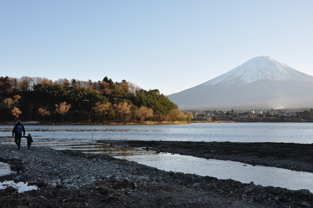
Mt. Fuji stands at 3,776 meters, and its volcanic nature is not a distant historical footnote. The 1707 eruption is the defining proof of that in recorded Japanese history.
The Earthquake That Most Likely Triggered the Eruption
The Hōei eruption was likely triggered by the largest earthquake in Japan's recorded history, which struck 49 days before the mountain erupted.
On October 28, 1707, the Hōei earthquake ruptured the entire Nankai Trough from Tōkai to Nankai simultaneously, with a magnitude estimated between 8.6 and 9.0. Tsunamis crashed into coastal communities across the Kii Peninsula and Kyushu. Then, seven weeks later, Mt. Fuji erupted.
The timing is not coincidence. When tectonic plates shift violently, the resulting stress changes can depressurize magma chambers beneath nearby volcanoes, effectively uncorking them. Geologists widely accept this causal chain as one of the clearest historical examples of earthquake-triggered volcanism on record.
This matters beyond history. The Nankai Trough remains one of the world's most active fault zones. Japan's disaster planners model both a future major Nankai rupture and a potential Fuji eruption as linked scenarios, not separate events.
What the Hōei Eruption Actually Did
The Hōei eruption ejected 800 million cubic meters of ash over a region stretching more than 100 kilometers from the mountain. That is enough volcanic material to bury much of the Kantō plain under a thick gray layer.
On the eruption's opening day, volcanic bombs and coarse ash buried communities at the mountain's base. Within hours, the ash column reached Sagami Province (modern Kanagawa). By December 17, ash was falling on Edo, darkening the capital's sky at midday.
In the hardest-hit Ashigara district, directly downwind, ash accumulated to 60 centimeters and deeper. Rooftops collapsed. Crops were destroyed instantly. Irrigation channels choked with volcanic debris, triggering floods along rivers throughout the Kantō region.
No official death toll from the eruption itself was recorded. The real human cost came later. Farmlands across the region remained unworkable for years. The resulting crop failures caused famines that persisted for nearly a decade.
The eruption also permanently reshaped the mountain. The southeast flank was gouged open by the new vents, altering the smooth volcanic cone silhouette that draws millions of visitors today. When you look at Mt. Fuji and notice a slight asymmetry on its southeastern slope, you are seeing the scar left in 1707. The Hōei crater is visible from many of the best Mt. Fuji viewing locations, particularly from the Gotemba and Subashiri trail approaches on the mountain's eastern side.
How Past Eruptions Created the Landscape You See Today
The Fuji Five Lakes and Aokigahara forest both owe their existence to a volcanic eruption far older than the Hōei: the Jōgan eruption of 864 AD.
That eruption was the opposite of 1707. Rather than ash, the Jōgan event sent massive lava flows pouring down Mt. Fuji's northwest flank. The molten rock entered the vast Lake Senoumi, which then filled the lowlands north of the mountain. The lava flows split the lake into two separate bodies of water.
Those two lakes still exist. They are Lake Saiko and Lake Shojiko, two of the five Fuji Five Lakes that frame the mountain in its most iconic photographs.
Aokigahara forest, that dense and eerily quiet wilderness known for its disorienting magnetic anomalies and interlocking root systems, grows directly on the Jōgan lava field. The trees are roughly 1,200 years old, the same age as the eruption that created the substrate beneath them.
This is what volcanic history actually looks like in person. When you photograph Mt. Fuji reflected in Lake Kawaguchiko, or walk through the silence of Aokigahara, you are standing on geology shaped by fire. The mountain's winter visibility is excellent partly because the lava plains to the north provide flat, unobstructed sightlines that would not exist without the 864 eruption. The Chureito Pagoda viewpoint in Fujiyoshida looks directly across terrain shaped by centuries of volcanic activity, and many visitors plan a day trip from Tokyo specifically to see these geological features up close.
What a Modern Eruption Would Mean for Tokyo
A Hōei-scale eruption today would deposit 2 to 10 centimeters of ash across most of Tokyo, requiring removal of an estimated 120 million cubic meters of material from the city alone.
The Tokyo Metropolitan Government's official ash fall modeling, updated in 2021, maps eruption scenarios across the capital based on wind direction and eruption scale. In 2025, Japan's Cabinet Office released an AI-generated simulation video showing the ash fall spreading across the 44-million-person metropolitan area. Roads clogged. Power grids failed. Wooden structures buckled under the weight of wet ash. The video accompanied an updated preparedness campaign tied to Japan's Volcanic Disaster Preparedness Day.
A government expert panel published updated response guidelines in March 2025. The central recommendation: stay indoors rather than attempt evacuation during initial ash fall, and maintain emergency food and water supplies. The panel stressed that their report "did not suggest the timing or possible scale of the volcano's next eruption." It was contingency planning, not a warning.
Total ash removal across all affected regions could reach 4.9 billion cubic meters in a worst-case scenario. For reference, that is more than ten times the debris generated by the 2011 Great East Japan Earthquake and tsunami. Economic damage projections for the Tokyo metropolitan area alone range from 1.2 to 2.5 trillion yen.
The Japan Meteorological Agency monitors Mt. Fuji around the clock, tracking seismic activity, ground deformation, and volcanic gas emissions. The volcano is currently at volcanic alert Level 1 (normal activity). No elevated alerts are in effect as of 2026. A similar long dormancy characterizes Mt. Rainier's eruption history in the Pacific Northwest, where monitoring programs keep watch over another volcano that has been quiet for centuries.
How Eruption History Affects Visibility Conditions
Mt. Fuji's volcanic past directly shapes how and when you can see the mountain today. The Hōei crater on the southeast flank creates a distinctive shadow pattern in afternoon light that experienced photographers use to time their shots. During spring cherry blossom season, the contrast between the dark crater scar and snow-covered summit is especially striking.
The ash deposits from 1707 also influenced the vegetation patterns on the mountain's lower slopes. The southeast face, which received the heaviest tephra deposits, supports different plant communities than the northwest face shaped by the older Jōgan lava flows. This asymmetry affects cloud formation patterns around the mountain, which in turn determines Mt. Fuji's visibility from different vantage points. The Mt. Fuji live camera feeds show this effect clearly on days when clouds cling to one side of the mountain while the other remains exposed.
Understanding the eruption history adds depth to any visit. The mountain you see from Tokyo on a clear winter morning is not just a scenic backdrop. It is an active stratovolcano wearing the scars of its last violent episode, surrounded by a landscape it created and destroyed across centuries of fire.
Frequently Asked Questions
When will Mt. Fuji erupt again?
No one can predict when Mt. Fuji will next erupt. The volcano has been dormant for over 318 years, longer than the typical interval between major historical eruptions. Volcanologists track the extended quiet but emphasize that dormancy duration alone does not indicate imminent activity. Mt. Fuji receives 24-hour surveillance from the Japan Meteorological Agency.
Was anyone killed in the 1707 Hōei eruption?
No direct death toll was recorded from the eruption itself. The mountain's immediate violence likely caused casualties near the new vents, but surviving records do not document numbers. The major human suffering came from the decade-long famine that followed, as ash-smothered farmlands across the Kantō region failed to recover for years.
Did the 1707 earthquake cause the Mt. Fuji eruption?
The evidence strongly suggests yes. The Hōei earthquake struck 49 days before the eruption with a magnitude of 8.6 to 9.0, likely altering pressure in Mt. Fuji's magma system. It is one of the best-documented cases of earthquake-triggered volcanism in recorded history.
Is it safe to visit Mt. Fuji given it is an active volcano?
Yes. Mt. Fuji is currently at volcanic alert Level 1 (normal activity), and millions of people climb or view the mountain each year. The official climbing season runs from early July to mid-September, with monitoring systems in place to provide early warning of any changing conditions.
The question of when it will happen again has no definitive answer. What history does provide is a precise picture of what happens when it does: 49 days of seismic precursor, two months of explosive ash fall, and decades of consequences for the millions living in the mountain's shadow.
For now, that shadow is something to seek out. Check Mt. Fuji's real-time visibility conditions before planning your visit. Is Mt. Fuji visible today is the only Fuji question with a live, updatable answer.
More Articles
Is Mt Fuji a Volcano? Active Status, Eruption History & Facts
Is Mt Fuji a volcano? Yes, it's an active stratovolcano that last erupted in 1707. Learn about its eruption history, current status, and what scientists predict for the future.
Mt Fuji Climbing Season 2026: Dates, Trails & Essential Guide
Plan your Mt Fuji climb with official 2026 season dates, trail comparisons, permit requirements, and essential gear. Everything you need to know before climbing Japan's highest peak.
Mount Fuji City: The Best Cities to Visit Near Japan's Sacred Peak
There is no single "Mount Fuji city," but four distinct gateway cities surround Japan's iconic volcano. Here's how to choose the right one.