Chinook Pass: Closure Dates, Rainier Views and Road Guide
Chinook Pass on SR 410: WSDOT closure dates since 1935, where Mount Rainier is visible on the drive, and what to know before you go.
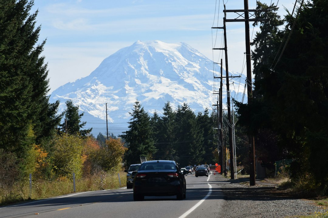
Chinook Pass is the 5,430-foot crossing of the Cascades on State Route 410, on the eastern edge of Mount Rainier National Park. It closes every winter and reopens in late spring, and in summer it's one of the closest roads to Rainier's east face. On the last two miles below the summit, Rainier's peak stands about 8 degrees above the horizon, more than three times as high as it looks from Seattle. Before you drive up for that view, check the live Mount Rainier visibility forecast, because the mountain hides more often than it shows.
Chinook Pass at a glance
- Elevation: 5,430 ft, on SR 410 between Enumclaw (45 miles west) and Naches (52 miles east)
- Status (evening of November 1, 2026): Open, bare and dry, wet in places, no restrictions (WSDOT)
- Typical season: Late May to mid-November. The median since 1935 is May 25 to November 16
- Winter gates: Crystal Mountain Boulevard, about 12 miles northwest of the summit, and Morse Creek, about 5 miles east
- Never allowed through the park: Commercial vehicles, at any time of year
Is Chinook Pass Open Right Now?
Yes. As of the evening of November 1, 2026, Chinook Pass is open, though any significant snowstorm could close it for the season. WSDOT's evening report listed the road as bare and dry, wet in places, with no restrictions, but overnight frost and snow can change that quickly. The National Park Service road status page, last updated October 29, estimates the closure for the season in "mid- to late November, weather dependent."
There has already been one close call. WSDOT closed Chinook and Cayuse passes on the evening of October 25 after heavy snow and several collisions, then reopened them around 1 p.m. the next day, the Courier-Herald reported.
For live status, use WSDOT's Chinook Pass page or call 511. In November the road can close for the season in a single afternoon.
Sunrise Road, the White River campground road and Stevens Canyon Road are already closed for the season. You can still drive over the pass, but you can't reach Sunrise or loop around to Paradise.
Chinook Pass Closure and Opening Dates Since 1935
Chinook Pass usually opens around Memorial Day and closes in mid-November, but the closing date has crept earlier over the past decade. WSDOT publishes every opening and closing date back to 1935. We ran the numbers on the 89 seasons with both dates recorded to turn that table into odds you can plan around.
| Date | Chance the pass is open (1935 to 2025) | Last 10 seasons (2016 to 2025) |
|---|---|---|
| May 15 | 19% | 0 of 10 |
| May 25 | 53% | 3 of 10 |
| June 1 | 73% | 7 of 10 |
| June 15 | 90% | 10 of 10 |
| July 1 to Oct 15 | 99 to 100% | 10 of 10 |
| November 1 | 91% | 7 of 10 |
| November 8 | 80% | 6 of 10 |
| November 15 | 57% | 3 of 10 |
| November 22 | 29% | 1 of 10 |
| December 1 | 13% | 0 of 10 |
Our analysis of WSDOT's historic opening and closing dates. Seasons with a missing open or close date (1976 and 1977) are excluded. Temporary closures, like October 2019's, aren't counted.
Some patterns stand out.
The fall closure is coming earlier. The median closing date is November 16 across all 89 complete seasons, but about November 9 over the last ten. The median season has shrunk from 182 days (1985 to 2009) to about 162. Before 2022, the pass had closed in October only three times in 87 years. Then it closed in October in three of the last four seasons: October 27, 2022, October 31, 2024, and October 24, 2025, the earliest closing on record. Ten seasons is a small sample, though, and the numbers alone can't separate weather from a more cautious closing policy.
2026 has already outlasted 2022, 2024 and 2025. Historically, when the pass is still open on November 1, it has stayed open to November 15 in 63% of seasons. In the last ten years, only three seasons made it that far.
Memorial Day is likely but not guaranteed. Since 1971, when Memorial Day moved to the last Monday in May, the pass was open by the Saturday of the holiday weekend in 38 of 54 years (70%). The 2026 reopening came by 8 a.m. on May 22, in time for the long weekend. Big snow years push it later (July 12 in 1974, the latest on record). The earliest opening was April 2, 2015.
Thanksgiving over the pass is a long shot. The road was still open on Thanksgiving Day in 12 of 54 years since 1971 (22%), and in just one of the last ten (2016).
The extremes are wide. The shortest season was 127 days (1946) and the longest 244 days (1941). The latest closing was December 18, 1974, the same year as the latest opening.
Where the Gates Close and How to Detour
In winter, SR 410 is closed from Crystal Mountain Boulevard to Morse Creek, and SR 123 is closed from the SR 410 junction south to the park's southern entrance near Packwood (WSDOT). Everything outside those gates stays open. You can still drive from Enumclaw through Greenwater to Crystal Mountain, which is how the ski resort works all winter. From the east, you can drive up the Naches valley past Cliffdell to just below Morse Creek.
Enumclaw to Naches is 97 miles and about 2.5 hours over Chinook Pass. In winter the usual detour is I-90 over Snoqualmie Pass (about 156 miles, a little over 3 hours); US 12 over White Pass is longer. Those are OSRM routing estimates for dry roads. And even in summer, Chinook Pass is no shortcut from Seattle to Yakima: it adds about 10 miles and roughly an hour compared with I-90. You drive it for the scenery.
Where You Can See Mount Rainier From SR 410
On SR 410 you see Mount Rainier from three stretches: the Enumclaw plateau, about two miles around the White River (Sunrise) turnoff, and the last 2.7 miles of the climb from Cayuse Pass to the summit of Chinook Pass. Elsewhere, ridges block it. We ran a line-of-sight check every 100 meters along the 97-mile route from Enumclaw to Naches, using roughly 30-meter terrain data with Earth's curvature and refraction, and measured how much of the mountain rises above the nearest blocking ridge.
| Stretch of SR 410 | Distance to summit | Mountain showing above the ridge | Height above horizon |
|---|---|---|---|
| Enumclaw | 26 mi | Upper 3,000 to 4,500 ft | ~5.5° |
| Greenwater and the White River valley (miles 2 to 36) | 15 to 26 mi | Hidden almost everywhere | n/a |
| Around the White River / Sunrise turnoff (miles 37 to 39) | 11 to 12 mi | Up to ~5,100 ft | ~10° |
| Cayuse Pass (SR 123 junction) | 10.7 mi | Hidden | n/a |
| Cayuse to Chinook climb, past Tipsoo Lake (miles 42 to 45) | 11 to 11.6 mi | 1,500 to 4,600 ft | 8 to 9° |
| East of the summit to Naches (miles 45 to 97) | 12 to 51 mi | Hidden, apart from one brief terrain gap | n/a |
Miles measured from downtown Enumclaw along the route. The model works from bare terrain, so roadside forest blocks many of the low-elevation openings in practice, and a different terrain dataset or observer height would shift the exact mileposts.
Three things follow from this.
The view stops at the crest. Driving east, Rainier is in sight right up to the top of Chinook Pass and disappears within a few hundred feet of crossing it. From there to Naches, about 50 miles, you won't see it again. If you're heading to Yakima, stop at Tipsoo Lake or a pullout below the summit before you cross. Driving west, the mountain appears all at once at the crest.
The Cayuse-to-Chinook climb is the best part of the drive. Above about 4,900 feet the road runs along an open slope with the mountain's east face straight across the valley. Most of that 2.7-mile stretch has 1,500 to 4,600 feet of the mountain in line of sight. Cayuse Pass, at the bottom of the climb, sits in a notch with no view at all.
Most of the drive has no view. Only about 19% of the road between Enumclaw and the crest has at least 1,500 feet of the mountain in terrain line of sight, and east of the crest it's about 1%. The few terrain gaps in the Greenwater valley are short, and roadside forest likely hides most of them.
Will the Mountain Be Out When You Drive the Pass?
Mount Rainier is most likely to be visible from Chinook Pass in July and August, when the summit gets a clear three-hour window on about two days in three. To estimate this, we pulled ten years (2016 to 2025) of hourly modeled cloud cover from the Open-Meteo historical archive for the summit, the pass, Enumclaw and Naches. We counted a day as a "view day" if the summit had at least three straight hours at or below 30% cloud between 8 a.m. and 6 p.m.
| Month | View day | Summit clear at 8 a.m. | Clear at 2 p.m. | Pass in low cloud at 10 a.m. |
|---|---|---|---|---|
| May | 29% | 27% | 17% | 21% |
| June | 37% | 36% | 25% | 17% |
| July | 68% | 65% | 58% | 7% |
| August | 65% | 58% | 49% | 8% |
| September | 47% | 44% | 34% | 11% |
| October | 35% | 30% | 28% | 26% |
| November | 22% | 16% | 16% | 43% |
Our analysis of Open-Meteo modeled hourly cloud cover, 2016 to 2025, local time. "Clear" means total cloud at or below 30% in the summit grid cell; "low cloud" means modeled low cloud of 80% or more in the pass grid cell. Modeled cloud is an estimate, not an observation of whether the peak was visible.
Two things matter as much as the month.
Go in the morning. In every month of the open season, the summit is clear more often at 8 a.m. than at 2 p.m. The gap is about 10 points from May through September. Evenings recover somewhat: in July, 6 p.m. matches 8 a.m. at 65%.
A gray morning in Enumclaw is a real warning. When Enumclaw was overcast (90% cloud or more) at 8 a.m. in August, the summit got a view day only 38% of the time, against 80% otherwise. In October the split was 8% against 63%. The east side is sunnier on average (Naches is clear at 1 p.m. on 70% of July days, Enumclaw on 54%), but when Enumclaw is overcast at 1 p.m., Naches is clear only about a third of the time in July and less in fall. Driving over the pass is not a reliable escape from the clouds.
For the day itself, use a forecast rather than averages. Our Mount Rainier visibility score rates whether the summit will be out, using a weighted atmospheric model of cloud cover, humidity, precipitation and visibility distance, with a 10-day outlook. Check it the night before and again before you leave, along with the Rainier webcams. For the climate behind those numbers, see our Mount Rainier weather guide.
What to Do at the Top of Chinook Pass
The summit of Chinook Pass is a trailhead area, not a town. It has a Pacific Crest Trail parking lot with vault toilets and the Tipsoo Lake picnic area just below, but no food, fuel or lodging.
- Tipsoo Lake, half a mile below the summit, has the pass's classic Rainier reflection. Our Tipsoo Lake guide covers where the mirror lines up and when to be there.
- The Naches Peak Loop circles the peak south of the road, partly on the PCT, with Rainier in view on the western half. It's in our Mount Rainier hikes roundup.
- Sheep Lake is 3.6 miles round trip with 400 ft of gain, north on the PCT from the east end of the lot (WTA). Leashed dogs are allowed.
- The entrance arch over the highway marks the park's eastern boundary. The Civilian Conservation Corps built it in 1936 on cedar logs and stone, as both a park portal and a bridge that carries the PCT over the road.
For a higher look at the same east face, the Crystal Mountain gondola is about 35 minutes back toward Enumclaw.
Where the Name Comes From
Chinook Pass takes its name from the chinook, the warm southwest wind that can melt deep snow in hours. That wind is named for the Chinook people of the lower Columbia River (Revisiting Washington). Today the highway over the pass is part of the Chinook Scenic Byway.
Before You Drive Chinook Pass
A few practical rules apply.
- No commercial vehicles at any time. SR 410 and SR 123 inside the park are closed to commercial traffic year-round.
- Carry chains from November 1. Between November 1 and May 1, every vehicle in Mount Rainier National Park must carry tire chains, including 4WD, AWD and rental cars. That covers a late-season crossing of the pass right now.
- Fees depend on where you stop. The PCT trailhead lot at the summit takes a Northwest Forest Pass or an America the Beautiful pass (WTA). Tipsoo Lake and Sunrise are inside the park and are covered by the park entrance fee, which our entrance fee guide breaks down.
- Fill up before you start. There's no fuel at the pass or anywhere inside the park, so fill up in Enumclaw or Naches. Packwood is the nearest full-service town to the south, but only while Cayuse Pass is open.
For how Chinook Pass fits with the park's other entrances and roads, see our Mount Rainier National Park guide and the park map guide.
Chinook Pass FAQ
When does Chinook Pass close for the winter?
Usually in early to mid-November, after the first major snowstorm. The median closing date since 1935 is November 16. Over the last ten seasons it's November 9, and in 2022, 2024 and 2025 the pass closed in late October. There's no fixed date.
When does Chinook Pass open in the spring?
Usually in the last week of May. The median opening date is May 25, and in 2026 the pass reopened on May 22. In heavy snow years the opening slips to late June or even July.
Is Chinook Pass the same as Cayuse Pass?
No. Cayuse Pass is the junction of SR 410 and SR 123, about three road miles and several hundred feet below Chinook Pass. The two usually open and close together, but Cayuse Pass itself has no view of Rainier.
One Last Look Before the Snow
The drive over Chinook Pass is worth it when two things line up: the gate is open and the summit is clear. Right now, the gate has a week or two left in an average year, and maybe less in a year like the last few. If you want one more look at Rainier's east face before the snow closes it, watch the live visibility forecast for Mount Rainier for a clear morning, carry chains, and get to the Cayuse-to-Chinook climb early in the day. Otherwise, the road reopens next May.
More Articles
Tipsoo Lake Mt. Rainier: Reflection Guide, Trail & Best Time
Tipsoo Lake at Mt. Rainier delivers the park's best east-side reflection. Learn the road window, where the mirror really is, and when to go.
Mount Rainier National Park Guide: Seasons, Areas and Odds
Mount Rainier National Park guide: fall 2026 closures, fees, the five park areas, and 10 years of cloud data on when you will actually see the mountain.
Crystal Mountain Gondola: Rainier Views, Odds & Tickets
Crystal Mountain gondola guide: 2026-27 prices, hours, what you see on the ride, and 10 years of data on how often Rainier is out at the top.