Lenticular Clouds: What They Are and What They Signal
Lenticular clouds are lens-shaped clouds made by mountain waves. How they form over Rainier and Fuji, and whether a cap cloud really means rain.
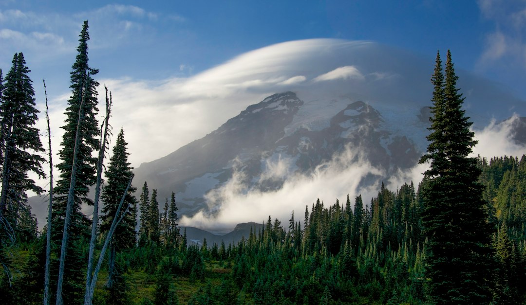
Lenticular clouds are smooth, lens-shaped clouds that form where wind flows over a mountain and sets up a standing wave in the air. They sit still while the wind blows straight through them, so they look less like weather and more like a parked spacecraft. Mt. Rainier and Mt. Fuji, two big isolated volcanoes, produce some of the best-known examples on Earth.
Both mountains also come with the same piece of folk wisdom: when the mountain puts on its hat, rain is coming. This guide explains how the clouds form, what the published odds say about that saying, and what a cap means if you're trying to see the summit.
What Are Lenticular Clouds?
A lenticular cloud is a stationary, lens- or saucer-shaped cloud that forms in the crest of a mountain wave. In the WMO's International Cloud Atlas, lenticularis is a species: clouds "having the shape of lenses or almonds, often very elongated and usually with well-defined outlines." It is a shape that three ordinary cloud types can take, named by height. The Met Office lists stratocumulus (low), altocumulus (middle) and cirrocumulus (high) standing lenticular, and groups them with other "orographic" clouds, meaning clouds made by terrain.
Around a single volcano, people use three names for three different things. They are easy to mix up, so here they are side by side:
| Cloud | Where it sits | Japanese name at Fuji | What drives it |
|---|---|---|---|
| Cap cloud | Directly on or just above the summit | Kasagumo (笠雲, "hat cloud") | Moist air lifted over the peak itself |
| Lee lenticular | Downwind of the summit, often floating free | Tsurushigumo (つるし雲, "hanging cloud") | Mountain waves downstream |
| Flag cloud | Trailing from the summit like a flag | Hatagumo (旗雲) | Low moist layers in strong wind shear, mostly in winter |
A cap cloud is often described as the first lenticular in the wave train, the one sitting on the mountain. A University of Tsukuba team studied three years of live-camera footage of Fuji (2019 to 2021) together with weather data and found the three behave as separate phenomena. Tsurushigumo were mainly mountain-wave clouds tied to moist layers high up. Caps had a similar seasonal pattern but quite different wind and humidity profiles. Hatagumo formed mostly in winter with moist air near the ground and strong wind shear, and the team found they differ fundamentally from the classic banner clouds of the Matterhorn.
How Lenticular Clouds Form
Lenticular clouds need three things at once: stable air, a strong wind blowing across the mountain, and a layer of air that is almost saturated at the height where the wave lifts it.
Stable air. Stable air pushed upward wants to sink back. Forced over a summit, it overshoots on the far side and bobs up and down like a spring as it travels downwind. That oscillation is the mountain wave.
Strong, steady wind. The wind has to cross the peak hard enough to set the wave going, ideally getting stronger with height. Gusty, turbulent air breaks the wave apart.
A moist layer near saturation. Rising air cools. If the layer lifted into a wave crest is already near its dew point, it condenses at the top of the crest, then warms and evaporates on the way down. Cloud forms on the upwind edge and dissolves on the downwind edge, so it stays put while the air races through. Several moist layers at different heights give the stacked "pile of plates" look.
Wind speed also sets the spacing between rows. In a worked example in Roland Stull's Practical Meteorology, a 30 m/s wind in stable air gives a natural wavelength of about 15 km (9 miles). Over a lone cone like Rainier or Fuji, the waves tend to make round saucers rather than the long bars seen over a straight ridge.
Do Lenticular Clouds Mean Rain?
Often, yes. On both Rainier and Fuji, a cap cloud is a traditional sign that rain is on the way within about a day, and the published Fuji figures put the odds well above a coin flip.
Seattle's KOMO weather team says that to locals the cap means rain usually within 24 hours. The reason is timing: the moist, smoothly flowing air the cloud needs tends to arrive in the hours before a Pacific weather system.
In Japan, the Ministry of Land, Infrastructure, Transport and Tourism page on Fuji's clouds puts the chance of rain within 24 hours of a kasagumo at about 70% in spring, autumn and winter and about 75% in summer. It adds that when a cap and a lee lenticular appear together, the hit rate is said to reach 80 to 85%. The page credits material from the Gotemba base office of the old Mt. Fuji weather station but doesn't say which years or what counted as rain, so treat the figures as a long-standing rule of thumb rather than a measured forecast.
The sign is not perfect. A cap tells you the air above the summit is moist and windy right now. It can't tell you whether a weather system will actually arrive.
There's one exception worth knowing. In Fuji lore, a detached cap (hanare-gasa) floating clear above the summit often means fair weather the next day.
What a Cap Cloud Does to Your View of the Summit
A cap cloud hides the very top of the mountain while the rest of the cone stays in plain sight. It makes a dramatic photo, but technically it isn't a clear view.
The visibility scores on our Rainier forecast and Fuji forecast handle this through the cloud-cover factor.
That factor in our weighted atmospheric model counts clouds at the landmark's own elevation more heavily than clouds elsewhere in the sky. A capped mountain under an otherwise blue sky scores lower than a clean summit. If the score is middling while the lowland sky looks perfect, a cap or summit cloud is a likely reason, and a quick look at a webcam will settle it.
At Rainier, the moist, windy Pacific flow that builds caps is a feature of the cool season, which is also when the mountain is hardest to see at all (our guide to Mt. Rainier visibility covers the monthly odds). On many of those days lower cloud hides the whole mountain anyway. If you do get a capped summit under a clear sky, take the photo that morning rather than waiting for the afternoon, because the weather behind the cap may be on its way.
Where to Watch Lenticular Clouds on Rainier and Fuji
The best place to watch is off to the side of the wind, where the cap and any lee lenticulars show in profile. Lee lenticulars form downwind of the summit, so in the westerly winds common at both mountains they usually sit on the east side.
Mt. Rainier. Seattle sits northwest of the mountain, about 60 miles away, and Tacoma is closer on the same side. On a southwest wind that's close to side-on, so the cities can see the stacked "pancakes" in profile. Seattle has a name for a clear view, explained in what "the mountain is out" means. A capped Rainier still counts, just with an asterisk. Inside the park, Paradise on the south slope looks up at the cap from the upwind side. The Mt. Rainier weather guide explains why the mountain makes so much of its own cloud.
Mt. Fuji. A kasagumo is visible from every side of the mountain. Tsurushigumo form on the leeward side, which Weathernews showed on the east side of Fuji in a westerly wind, so the eastern lakes and towns are a good place to look. Lake Yamanaka sits on that side of the mountain.
On the northwest side, Lake Shoji can reflect a capped summit on a calm morning. Our Mt. Fuji photography guide covers exposure and timing for both lakes.
The same physics works on other big peaks. Denali, the Sierra Nevada and Patagonia all get spectacular wave clouds. Rainier and Fuji just have millions of people living within sight of them.
Are Lenticular Clouds Dangerous?
The cloud itself is harmless. The danger is the wave that made it, and the turbulence that can sit beneath it.
Powered aircraft generally steer clear. Mountain waves carry strong up- and downdrafts, and beneath the crests a tumbling eddy called a rotor can form near the ground, sometimes marked by a ragged rotor cloud. Stull notes that the strongest waves "pose the threat of violent turbulence to aircraft." Waves can also form in air too dry for cloud, so a clear sky doesn't guarantee smooth air.
Glider pilots read the same clouds as a map of free lift. On September 2, 2018, the Airbus Perlan 2 sailplane reached a pressure altitude of 76,124 feet in mountain waves near El Calafate, Argentina, an unofficial glider record according to AOPA. That topped the 73,737-foot altitude mark set in a U-2 spy plane in 1989.
On the ground, the hazard is mostly to climbers. A cap means the summit is inside a cloud in strong wind, so whiteout and wind chill above the cap's base are a given while it lasts.
Saucers, Spaceships and a False Eruption
Lenticular clouds look so artificial that the Met Office says they are believed to be one of the most common explanations for UFO sightings. Their smooth edges, perfect symmetry and refusal to move with the wind all suggest a machine rather than weather.
At Rainier they once caused a different scare. On September 7, 2022, a video of a cloud billowing off the summit spread online as possible volcanic venting. The USGS said the volcano was not erupting, the Pacific Northwest Seismic Network recorded no unusual seismic or infrasound signals, and scientists reviewing several webcams identified the cloud as a lenticular. Rainier is an active volcano (see what an eruption would look like), but a smooth cap that holds its place over the summit is weather. A volcanic plume rises from a vent and drifts away downwind.
Quick Answers
Are lenticular clouds rare? Over flat country, yes; the Met Office calls them "quite unusual in the British Isles." Near a big isolated peak like Rainier or Fuji they're a familiar sight.
Can lenticular clouds form without mountains? Occasionally. Hills can trigger small waves, and wind shear near a front can make lens shapes over flat ground. The big stacked saucers almost always need a mountain.
Is a lenticular cloud the same as a pileus? No. A pileus is a thin, smooth cap that forms briefly over a fast-growing cumulus or thunderstorm cloud. It looks similar, but a rising cloud makes it, not a mountain wave, and it usually lasts only minutes.
Reading the Hat
A cap cloud on a clear morning tells you two things. The air above the summit is windy and moist, and rain often follows within about a day. The view in front of you probably won't last until tomorrow.
On those mornings, take the photo early, then check the live Mt. Rainier visibility score or Fuji forecast to see how quickly the weather is moving in.
For the week ahead at Fuji, our Mt. Fuji weather forecast guide explains which forecasts to trust.
More Articles
Mt. Rainier Visibility: When You Can Actually See the Mountain
Mt. Rainier visibility depends on cloud cover, season, and time of day. See monthly patterns and how to check conditions.
Mount Fuji Visibility: Complete Guide to Clear Views by Season, Time, and Location
Mount fuji visibility depends on season, time of day, and humidity. This guide covers monthly statistics, best viewing spots, and how to check real-time conditions.